Full Length Research Paper

ABSTRACT
The Gish Abbay area is among one of the environmentally most affected areas where environmental deterioration has prevailed. A lot of factors have contributed to this negative development. The major ones are rapid population growth, poverty and inappropriate forest and land related laws and legislations. Among others, however, this paper attempted to highlight how government land policy over many years was responsible for deforestation in the area. It has been argued that the land reforms that were introduced during the two consecutive Ethiopian regimes, the imperial and the Derg, had an impact on the forest coverage of the area. Among these reforms, the frequent allocation of land to the patriots and other individuals that rendered services to the government, particularly in the post-liberation period, can be cited as one example of the reform. The frequent allocation of land, as a reward, was made at the expense of forests. The introduction of the first forest legislation in the mid 1960s by the state had been considered as a turning point in the use of forests communally. The regime had often claimed all forests as state property, a policy that challenged the previous tree tenure system. Thus, in order to show their hostility against the government, the peasants cleared forests and converted to cultivated land. The seizure of power by a new government, that succeeded the imperial regime in 1974, brought about a new land reform that nationalized all natural resources including land. The regime made frequent and periodic re-distribution of land within some years interval in order to satisfy the growing demand of the local population. Accordingly, the distribution and redistribution of land, the introduction of cooperative farming, the villagisation programme and the formulation of forest laws and legislations were undertaken throughout the reign of the military government. These all government reforms had its own contribution for the massive deforestation of the period. Thus, this research attempted to shed light on both continuity and change in the process of land reform and its implications to deforestation, throughout the two successive regimes; the imperial and the military. In order to achieve the research objectives, in depth interview and focus group discussion were utilized in addition to the results of the research undertaken by other scholars. The study referred data analysis from other disciplines such as the Geographic Information System (GIS) to see changes in the forest coverage of the area during the two consecutive regimes.
Key words: Deforestation, causes, land reform, Gish Abbay, forest legislation.
INTRODUCTION
Geographical setting and general background
Numerous researchers from different disciplines have produced literatures on Ethiopian land reform, giving due emphasis to the impact of land tenure system on tenure insecurity and land degradation. However, this paper will make a historical investigation on the impact of land reform on deforestation by taking the Gish Abbay area as an example.
Gish Abbay watershed is located in West Gojjam Administrative Zone in Sekela district in the Amhara Region. It covers about 159.19 km2. Agriculture is the main economic activity of the area. In 2004, Woreda had an estimated population of 174,752, out of which the rural population constituted about 171,193. The dominant ethnic group and religion in the area were the Amhara and Orthodox Christianity (Getachew, 2005; Solomon, 2005).
The Gish Abbay area, as noted by Teferi (2004), had attracted the attention of many travellers and missionaries since the early 17th century. The area is believed to be the source of the Blue Nile. Among those missionaries and travellers, the Portuguese catholic priest Pedro Paez, visited the Gish Abbay area with Emperor Susenyos in 1613 (Teferi, 2004). The ambition of Portuguese catholic priests such as Pedro Paez, Manuel de Almeida and Jeronimo Lobo, who visited the Gish Abbay area in the early 17th century, was not to discover the source of the Nile, rather they had the ambition to dismantle the well entrenched Ethiopian Orthodox Christianity that became an official religion since the first half of the 4th century AD. In any case, most scholars regarded Pedro Paez as the first European to reach the area. The other Portuguese Jesuit missionary, who visited Ethiopia in the early 17th century, was Manuel de Almeida. He visited the entire Gojjam during the reign of Susneyos.
The Scottish explorer, James Bruce was also in the area and produced a five volume account, entitled: Travels to Discover the Source of the Nile in the Years 1768-1773. James Bruce was notably the second European traveller who came into Ethiopia after the adoption of a close door policy. Since the seizure of power by Emperor Fasiledos in the 17th century until the mid 19th century, the country isolated itself from any contacts with anything European. In spite of this, the two exceptional figures who came into Ethiopia during this period were Poncet and James Bruce. The former came to Ethiopia by the order of Emperor Iyasu I (r.1682-1706) to cure his skin disease while the later arrived in the country in 1769, having the ambition to discover the source of the Nile. James Bruce made two attempts to discover the source of the Blue Nile, however, it was during his second attempt during which he taught he succeeded in discovering the source.
In the early twentieth century, Major Robert Chessman, a British Consul at Dangila (North-western Ethiopia), “made the first recorded trip along the full course of the Blue Nile River, on foot and mule.’’ His travel to Gish Abbay is stated as:“from Dangila to the spring at Gish Abbai, if a traveller is moving slowly, is a four-days’ journey by mule (Chessman, 1936).’’
Soon after his visit, Chessman produced two accounts; entitled the Upper Waters of the Blue Nile, Lake Tana and the Blue Nile, dealing with the geographical description of the Gish Abbay area. All these travellers and missionaries produced their own accounts and provided a description about the source of the river and its natural resources. Soon after, these missionaries and travellers declared the Gish Abbay area as the source of the Blue Nile, a river that contributes 86% of its water to the Nile (the longest river in the world) while hydrologists quote Lake Tana as a source of the Blue Nile.
There activities had not been limited to the introduction of the river and its history to the outside world but they also testified that the area was endowed with abundant and remarkable natural resources. Manuel de Almeida, for instance, witnessed the existence of dense forests in Gojjam in comparison with other parts of Ethiopia. He stated as follows;
Generally speaking, there is not much woodland in Ethiopia. In some parts, especially in Gojjam, there are forests of trees of various kinds, like wild Cedars (Junipers procera); Anza (wanza)(cordial Africana) is a good timber…The whole of this country is well supplied with thorn bushes and the trees are so tall that where there are many of them together they seem to be groves of pines rather than thorn bushes; they are used for fire wood. There are many tall thickets of bamboo (Manuel de Almeda, 1954).
James Bruce in his book, among others, witnessed that the Gish Abbay area was covered with dense forests such as timber trees, acacia, thick woodlands, bamboos, yellow rose, cusso trees and others in the period under question (Bruce, 1840). Robert Chessman (1936), who went to the area in the 1920s, testified that the area was one of the most forested area in the country, noted “for most of the way the land is covered by forest, no views are obtained.”
However, the forest coverage, which was once dense, has disappeared from the surface of the earth attributed to economical, social, political and cultural factors. Among those factors, this paper specifically deals with how land reform could have been a cause for the destruction of forests in the area. This paper argues that the land reforms that were introduced since the post-liberation period until the overthrow of the military government in 1991 were responsible for the massive deforestation in the area. Since the restoration period, the government made frequent allocation of land to the individuals and made a firm control over communal forests, which were owned and managed by the community prior to the mid 1960s. It became apparent that the government’s failure to avoid the inconsistent land tenure system accompanied by other factors led to the overthrow of the regime. The overthrow of the emperor in 1974 was followed by a series of measures that changed the complex land tenure system of the regime.
It is interesting to note that, however, one year later after the seizure of power by the Derg, the nationalization of both urban and rural lands came to exist. Soon after, periodic and frequent distribution and re- distribution of land happened to be the characterizing features of the land reform. In 1980, the government issued a forest management law which deprived the local people to use forests for fuel wood or construction purposes. As will become evident in the next section, the 1980s cooperative farming and villagisation programme were also parts of the land reform, which had been a factor for massive deforestation in the area. Thus, how governments land policy over many years had been a factor for deforestation will be discussed in detail because the study of deforestation has its own contribution since the Gish Abbay area is located in the source basin of the Blue Nile Basin.
METHODS OF STUDY
For the purpose of this study, both primary and secondary sources were used. Primary data were collected through interviewing key informants and focus group discussion. The researcher used purposive sampling which constitutes the best research design for this qualitative study, since it was the researcher that chose those informants who could have been a source of information. Interview and focus group discussion were made with purposely selected elders, peasants who participated in the cooperative farming of the 1980s and peasant associations, who are believed to have deep knowledge about the issue under discussion.
Moreover, interview was also made with local administrators of the imperial and the Derg regime, since these people had played a great role in the implementation of land tenure policies of the regimes at grass root level. In order to get detail information on people’s experience, feelings and attitudes during the implementation of the land reforms of regimes, open-ended questions were prepared. For the un-structured interview two focus group discussions with eight participants and twelve key informants were selected.
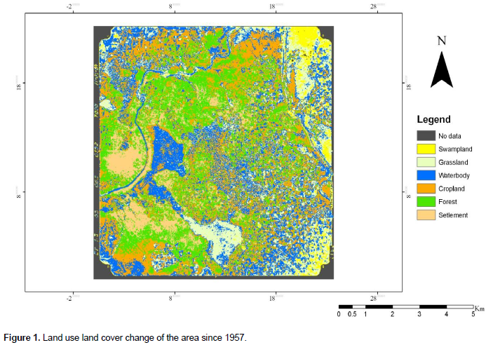
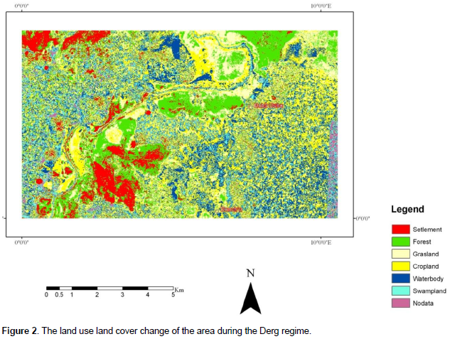
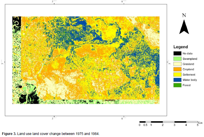
The study was also carried out by employing image analysis and GIS technologies to generate data on the land use land cover change that took place in the area during the two successive regimes. For this purpose, the 1957 and 1984 aerial photographs, obtained from the Ethiopian Mapping Authority (EMA), were employed.
This method was useful to make comparison between the forest coverage of the area of 1957 and 1984. In this case, the study used a mixed approach, comprising both qualitative and quantitative methods, despite the fact that the former took the lion’s share of the study. Moreover, in order to substantiate the data, secondary sources were also gathered from research papers and historical documents. Finally, the data collected through key depth interview, focus group discussion and remote sensing were examined, analyzed and interpreted in order to reconstruct the history of land reform and its implications to deforestation in the Gish Abbay area.
Land reform and deforestation
The imperial era (r.1930-1974)
Many have argued that the early years of the imperial regime were witnessed with the existence of dense forests in the country. In this period, communal ownership of trees was one of the characterizing features of the land tenure system of the regime. The study area, as witnessed by local elders, traveller accounts and other researchers, was covered with indi-genous trees mainly Juniperus (tid), Ricinus communis (koba), Arundinaria (kerkeha), Murus mesozyoia (injori), Olea forests (weira), Euphorbia abyssinica (kulkual), Hagenia forests (kosso), Dombeya torrid (welkefa), Erythrina Abyssinia (korchi), Emberia schimperi (enkoko), and Eucalyptus globules (nechi Bahirzaf) (Solomon, 2005).
Since the restoration period (Solomon, 2005), however, the study area which was once covered with dense forests has experienced massive deforestation, land degradation and loss of biodiversity.
It is worth to mention that indigenous natural forests “except in churchyards and along rivers" have disappeared and replaced by recently introduced trees (Solomon, 2005). This was partly attributed to the state’s inconsistent natural resource policy (Dessalegn, 2001). In this period all forest resources came under the control of the Ministry of Interior. However, in the 1950s the Ministry of Agriculture particularly its forestry department came to assume responsibility to preserve forest resources in the country, in general (Bahiru 2008).
Regardless of the attempt of the government to protect the forests, the state frequently attacked the forests for various purposes. The government repeatedly allocated land as a reward to patriots, who defended their country from Fascist Italian invasion (1936-1941) and for those individuals who rendered military and religious services. As a result, forested lands, bushlands and grazing lands were converted to agricultural fields which in turn contributed to deforestation.
Likewise, the mid 1960s was also witnessed with the establishment of forest legislation in the country which recognized three forms of forests namely; state, private and protected forest. The legislation had, specifically, three proclamations No.225, No.226 and No.227 Proclamation No. 225 recognized state forests and No. 226 and No. 227 recognized private and protected forests respectively (Lemma 1997).
Dessalegn (2001) described the situation as: “the legislation placed all large forests under state ownership, and put sever restrictions on the use and management of private forests.” The legislation claimed all forests, lakes and river systems to be a state property. It is quite evident that the legislation discouraged communal ownership of forests which had been a common practice prior to the 1960s. The claim over forests represented one of the major antagonisms between the central government and the peasants (Dessalegn, 2001). This was particularly true in the study area, though the problem was not as serious as that of Wollo, as the study of Dessalegn (2001) explicitly noted. The government appointed guards (chika shums’) to protect forests from illegal cutting. When such type of protection was made the local population started to assume that the forests belong to the state. Thus, in order to show their discontent against the government, individuals cleared large tracts of forestland, vegetation and pastureland and converted to cultivated land. Soon after, the regime was forced to give up its claim over forests, due to the seriousness of the opposition.
The Derg Period (r.1974-1991)
Following the overthrow of the imperial regime, the public ownership of rural land proclamation No.31/1975 was issued. The proclamation stated that “as of effective date of this proclamation, all lands shall be the collective property of the Ethiopian people.” The military government abolished the traditional forms of land tenure system that had been practiced in the pre-revolution period. The significance of the land reform, particularly for the poor who were deprived of their rights due to the imperial regime’s land tenure system is clearly stated in the proclamation No. 31/1975, as if large holdings were controlled and misused by the few. The government argued that the redistribution of land was the only measure to avoid or at least minimize the increasing number of the landless (Federal Negarit Gazeta, 1975), whose survival cannot be guaranteed without land.
It has often been argued that unlike the pre-revolution period, the 1975 land reform brought about some changes. The landless peasants including the Muslims, who did not own land in the pre-revolutionary period, were allowed to take part of their shares. It ended land-lord tenant relationship, even though tenancy was less in the area (Temesgen, 2013). The reform made the peasants free from the exploitation of their labour by the land holders. Moreover, the 1975 land reform encouraged married couples to own land.[i] But for the northern part of Ethiopia, the new land reform did have its own implication for the peasants, whose privilege over lands was intact.
Despite its merit, it should, however, be noted that the reform resulted in inappropriate land use practices, massive deforestation and land degradation. In the northern part of Ethiopia including Gojjam, in which the study area forms apart, the new land reform dismantled the rist arrangement. The predominant land tenure system prior to 1975 in the area was rist, which allows families to have a group right to use land for indefinite period of time. The land had been acquired through birth. In this case, almost all peasants, with the exception of few owned large tracts of land. This means that there was no land lord-tenant relationship as far as every peasant did have the right to own land based on their ancestors. Nevertheless, when this new land reform had been introduced by the regime, the peasants felt that the government was intimidating their rights over lands. Thus, the land reform for the majority of the peasants was very serious. As a result, the land reform was not welcomed by the local population (Temesgen, 2013), whose attachment to their land is inviolable. Therefore, the central government faced a firm opposition from the peasants of Gojjam. Here, it is worth mentioning that the study area was not an exception.
The grievance of the peasants against the central government was aggravated, as local elders witnessed, when the government declared a new law on forest and wildlife conservation in 1980. The proclamation No.192/ 1980, as cited in Sisay (2008), blamed the imperial regime for the inappropriate use of forest resources as if ‘‘the selfish interest of the aristocracy and the nobility’’ led to the worsening condition of the environment.[ii] Hence, the only way to preserve the remaining forests was by keeping the forests away from the community. Subsequently, the military government prohibited the society from touching a single forest including private trees, planted around farms and homesteads. Sooner, they all became under the jurisdiction of the state. For that reason, as usual, the local population responded by converting protected forests into agricultural fields, as a response to their antagonism.[iii]
The protection of natural forests by the government was followed by the state’s intervention in soil conservation and afforestation programs. The regime seems to be aware that the environment could not be restored unless soil conservation and afforestation programs were undertaken. As historical records witnessed, afforestation for the first time in the history of Ethiopia started in the early 15th century by the order of King Zera-Yakob (r.1434-1468). However, modern tree planting started during the reign of Emperor Menillik II (r.1889-1913) to solve the shortage of firewood in the capital, Addis Ababa. During the Derg regime (r.1974-1991), large scale afforestation and soil conservation on farms and community lands took place in the country in general and the study area in particular (Amogne 2013).
Some sources have further argued that the program was assisted by both national and international organizations. The Community Forestry and Soil Conservation Department of the Ministry of Agriculture took responsibility in the planning and implementation of soil conservation measures and afforestation programs. The main objectives of these activities were to solve the shortage of fire wood and construction materials, to reduce soil degradation and improve the productivity of lands and to reduce the pressure from the remaining natural forests and conserve biodiversity. It was also aimed to increase the sources of income for the community particularly from trees planted outside protected areas. The program was mainly involved in three major activities; farm forestry, community forestry and soil conservation. Farmers were encouraged to plant trees around homesteads and on community lands. In response to their work, peasants were provided with grain and vegetable oil. About 181,000 hectares of land was afforested by the Community Forestry Program throughout the country including the study area particularly at Gunedel kebele (Badege 2001).
While significant success had been recorded, it was not without negative outcomes. In the first place, as it was witnessed by the local elders, forests and soil conservation measures took place on peasant holdings and grazing lands. The peasants were even not allowed to graze their animals around the `planted trees. Moreover, there was no clear policy whether the community would own community forests. Therefore, the afforestation program was a threat to many peasants because the government frequently attacked and confiscated their land. Moreover, the farmers did not perceive these programs as something that brings long term development rather, the immediate return of the program was perceived as an important part of incentives. In this case, the government did not succeed to obtain community support (Badege, 2001). Owing to this, the afforestation activities had been declined through time and encroachment on forests was continued throughout the reign of the military government. Having this in mind, it may be pertinent to raise questions whether the program have succeeded in achieving its expected objectives.
Thus, it is acceptable to argue that government’s land policy was responsible for the degradation of the environment in the area. Desalegn (2001) in his study argued that “the worst enemy of environmental protection programs in this country was not peasant agriculture, nor population pressure, but the government itself.”
Most significantly, throughout the reign of the military government, many of the local elders remembered those periods in which massive deforestation was present in the area. To begin with, the first massive deforestation occurred in 1975 when the government distributed and re-distributed land for landless peasants based on their household sizes. Since 1975, frequent reallocation of cultivated land within some years interval was commonly practiced to satisfy the newly formed households. In this distribution, ten hectares were declared to be the maximum amount to be allocated to landless peasants. But, there were some exceptions in which strong farmers could receive more than ten hectares, through an assessment of the potential of a farmer to plough and produce more. For this purpose, forests and bush lands were cleared and grazing lands were converted to agricultural fields without even thinking about the damage to the forests caused by the frequent allocation of cultivated lands.[iv]
Secondly, the other massive deforestation occurred in 1980 when the government re-allocated land for the expansion of cooperative farming to increase agricultural production. In order to achieve its plans, the government took more fertile land from the communal forests, grazing lands and private protected areas, which in turn led to deforestation.[v] Nonetheless, the cooperative farming was not welcomed by the peasants because the military government gave less attention to peasant agriculture which led to the decline of agricultural productivity.[vi] As a matter of fact, the decline of agricultural production forced the peasants to search for alternative sources of income like cutting down trees for selling to the nearby markets. Thirdly, the villagisation programme, which was introduced in the second half of the 1980s, was also responsible for the destruction of forests in the area. The program was carried out on a large scale which was accompanied by extensive de-forestation during the construction of new villages. It is equally interesting that in 1991, when the Derg regime lost its power, a serious deforestation which had never been seen before occurred due to absence of incentives, tenure insecurity and memories of oppressive government.[vii]
Compared with the deforestation caused as a result of the decree in the 1960s, the one after the 1975 land reform was very sever. This was because, following the overthrow of the imperial regime, natural forests and trees planted around farms and homesteads were cleared by the local communities as a response to the reform. The local community felt mistreated by the government and since the community was entirely dependent on the land they had, they responded by cutting trees indiscriminately. This action since the introduction of the first forest legislation until 1991 had contributed a lot to the deterioration of the environment. Thus, environmental degradation became more sever during the Derg regime. However, it has been impossible to say deforestation was only the product of land reform.
As was discussed earlier, deforestation in the area has been caused by factors such as population pressure, lack of alternative sources of income and energy, land reform and inappropriate land use practices. Deforestation caused by land reform is already discussed above, but how frequent distribution of land for cultivated land, Cooperative farming and villagisation affected the forest resources of the area will be discussed below by applying geographic information system employing the 1957 and 1984 aerial photographs (Table 1 and Figures 1, 2 and 3).
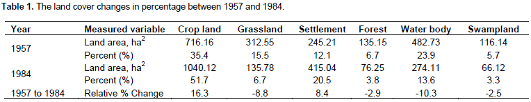
Based on the data, six major land-cover types were identified in the study area such as settlement, forest (includes natural forest, plantations, riverine trees and bush lands), grassland, crop-land, water body, and swampland. As shown above, of the total catchment area (15362 ha) in 1957, the dominant land cover type which constituted about 4049.32 ha (26.52%) was crop land. The forest coverage was also the second largest land cover type which constituted 3663.19 ha (23.99%) followed by grassland covered with 3039.55 hectares (19.90%). During the period in question, the water body represented about 2810.59ha (18.41%) of the area followed by settlements which represented about 1448.21 ha (9.48%) of the total area. The least is the swampy land which covered about 259.14 ha (1.70%).
It is interesting to note that with the exception of cultivated land and settlement areas, all land cover types showed a marked decline. Crop-land, for example, continued to be the dominant land cover type in the area which covers 7734.45 ha (50.65%) followed by settlement which was increased to 2237.61ha (14.65%) in 1984. Whereas, the other forms of land cover types showed a decline in the same year. For example, the water body decreased to 1394.08 ha (9.13%), grassland declined to 1245.78 (8.6%), forested land was also reduced to 2549.32ha (16.70) and swampy land declined to 0.71%, out of the total area.
From the Table 1, we can infer that, there has been an increase in crop land from 26.52% in 1957 to 50.65% in 1984. This expansion could only have taken place at the expense of forests, grasslands and water bodies. This was probably the product of the frequent and periodic distribution of land for the landless peasants within 4-5 years interval since 1975 until the overthrow of the regime. Moreover, the expansion of cooperative farming might have its own contribution for the expansion of agricultural fields.
On the other hand, the disappearance of indigenous forests in the area might be the product of the 1975 land reform when private ownership of natural resources was prohibited which discouraged peasants to make investments in their land like tree planting, which was commonly practiced prior to the early years of the imperial regime. Moreover, as it was noted earlier, the 1980s cooperative farming was also responsible for the destruction of forests, because the program took place by clearing forests.
Here, it should not be forgotten that settlement areas increased from 9% in 1957 to 14% in 1984. The expansion of settlement in the area, as it is clearly seen in the map, could have been the result of the government’s villagisation programme of the early 1980s. In this program, many new villages were built, at the expense of forests.
[i] Informants: Tiruneh Wubetu, interview with the author, 24 January 2012, Sekela.
[ii] Sisay N, “Ethiopian Government Efforts to Increase Forest Cover: A Policy Oriented Discussion Paper,’’ (Addis Ababa, 2008); Informants: Workeneh Temesgen, interview with the author, 24 January 2013, Sekela.
[iii] Informants: Workeneh Temesgen, interview with the author, 24 January 2012, Sekela.
[iv] Informants: Worku Alemayehu, Hiwot Abebaw, Setegn Tadele, Alemitu Workineh, Sitotaw Amare and Tadele Derse, interview with the author, 24 January 2012, Sekela.
[v] Informants: Workeneh Temesgen and Tadele Derse, interview with the author, 24 January 2012, Sekela.
[vi] Temesgen, pp.149-152; Informants: Abebe Alemu and Tarekegn Hunegnaw, interview with the author, 24 January 2012, Sekela.
[vii] Informants: Abebe Alemu and Tarekegn Hunegnaw, interview with the author, 24 January 2013, Sekela; Teferi R, “Environmental Problems and Policies in Ethiopia,” In Proceedings of a Workshop on the Twenty Fifth Anniversary of the Institute of Development Research Nov, 26-28, 1998 (ed.) Tägägne, AbdulHamad, Wärkänäh, Dlenäsaw, (Addis Ababa, 1998), pp. 358.
CONCLUSION
The Gish Abbay area had been known for its natural resource endowment particularly prior to the early twentieth century. However, the natural resources of the area have declined through time due to the inappropriate land tenure system, poverty and rapid population growth. The land tenure system of the two consecutive regimes contributed a lot for massive deforestation in the area. The claim of the government over forest resources, nationalization of land, frequent and period redistribution of land, cooperative farming and villagisation reduced the forest coverage of the area from 24% in 1957 to 16% in 1984. At the same time, crop land was increased from 26 to 50% between 1957 and 1984 which was the result of frequent and periodic re-distribution of land.
Thus, it is to conclude that the land policy of the regime and regular interventions contributed a lot for under-mining the rights of individuals and communities to use and manage their own resources. Therefore, it is worth mentioning that the land reform and policy of the government should be designed in a way that it would enhance the participation of the community from the beginning to the end as far as the objective of the intervention was to prevent or restore the degradation of the environment and to improve the livelihood of local community. Forest resource management should be accompanied by the free consent and participation of the community; otherwise, it would end up with negative consequences.
CONFLICT OF INTERESTS
The author has not declared any conflict of interest.
REFERENCES
|
Amogne A (2013). Forest resource management systems in Ethiopia: Historical perspective. Addis Ababa, Ethiopia.
|
|
|
|
|
|
Badge B (2001). Deforestation and Land Degradation on the Ethiopian Highlands: Strategy for Physical Recovery. Northeast African Studies 8(1):7-26.
Crossref |
|
|
|
|
|
Bahiru Z (2008). Society, State and History: Selected Essays. Addis Ababa, Addis Ababa University Press.
|
|
|
|
|
|
Bruce J (1840). Travels to Discover the Source of the Nile in the Years 1768, 1769, 1770, 1771, 1772 and 1773. Edinburg: London.
|
|
|
|
|
|
Chessman R (1936). Lake Tana and the Blue Nile-an Abyssinian Quest. Macmillan Co. London.
|
|
|
|
|
|
Dessalegn R (2001). Environmental Change and State Policy in Ethiopia: Lessons from Past Experience. Forum for Social Studies Monograph Series 2. Addis Ababa. Ethiopia, 10-108.
|
|
|
|
|
|
Federal Negarit Gazeta (1975). Public Ownership of Rural Lands Proclamation No. 31/1975. Addis Ababa.
|
|
|
|
|
|
Getachew A (2005). Determinants of Land Degradation in the Lake Tana Basin and its Implications for Sustainable Land Management: A case of Angereb and Gish-Abbay Watersheds. MA Thesis, Alemaya University.
|
|
|
|
|
|
Lemma E (1997). "Fuel Wood and Environmental Impact in Ethiopia," Paper Presented for the Seminar on Energy Policy and Environment, Nov, 9-12/1992.
|
|
|
|
|
|
Manuel de Almeda (1954). Some Records of Ethiopia, 1593-1646, (ed.) C.F. Buckingham and G.W.B. Hunting ford, (London: Hakluyt Society, 1954), p. 48.
|
|
|
|
|
|
Sisay N (2008). "Ethiopian Government Efforts to Increase Forest Cover: A Policy Oriented Discussion Paper." In Bane J, Sisay N, Alemu M, Randall B (edts.) Polices to Increase Forest Resources of Ethiopia, Proceedings of a Policy Workshop Organized by Environmental Economics Policy Forum for Ethiopia (EEPFE) and Ethiopian Development Research Institute (EDRI): Addis Ababa, Ethiopia.
|
|
|
|
|
|
Solomon A (2005). Land Use Land Cover Change in the Headstream of Abbay Watershed, Blue Nile Basin, Ethiopia. Msc Thesis, Addis Ababa University.
|
|
|
|
|
|
Stefan D, Daniel A (2007). Land Rights, Power and Trees in Rural Ethiopia. University of Oxford.
|
|
|
|
|
|
Teferi M (2004). The Blue Nile Issue: A History of Hydro-politics, 1884-1974. MA thesis, Addis Ababa University
|
|
|
|
|
|
Temesgen G (2013). Peasants, Land reform and Property Right in Ethiopia: The experience of Gojjam Province, 1974 to 1997. Journal of African Studies and Development.
|
|
Copyright © 2024 Author(s) retain the copyright of this article.
This article is published under the terms of the Creative Commons Attribution License 4.0


