ABSTRACT
This study was carried out to evaluate the effects of plantation agriculture on land use, land cover change in the Nguti sub division and to investigate resident’s perception about the effects of land use, land cover change on local climatic variability. Satellite maps from Landsat multispectral images were processed using Arc GIS 8 to assess land cover change overtime. Structured questionnaires, focused group discussions and interviews were used to gather relevant data on resident’s perception on the impacts of land use, land cover changes on climate variability. The statistical package for social science (SPSS) version 19 was used to analyze respondent’s perception on the impacts of land use land cover change on local climatic variability. Results indicate a slow change in dense forest of -2% between 2006 and 2012 when no large scale agricultural practice existed, as opposed to a rapid change of -14% between 2012 and 2015 when such practice existed, indicating a massive loss of forest cover. Plantations increase slightly between 2006 and 2012 (51 ha) but witnessed a massive increase (210ha) between 2012 and 2015. Residents of Nguti sub division attest that there has been variability in the climatic condition in the area experience in the form of increase temperature, reduction in rainfall and changes in seasonality. Authors recommended a need for a participatory land use planning to delimit and allocate land into various land uses and to avoid future land use conflicts.
Key words: Dense forest, palm plantation, settlements, respondents, variability, livelihood change.
Plantations are essential for human survival and economic wellbeing as well as for the ecosystem structure, functioning and stability (Bargali et al., 1993). However, environmental groups, ecologists, economists, and others have expressed concern that agricultural programs that stimulate production can have unintended and undesired environmental consequences. This view is based on two ideas: first, that as more land is used in agricultural production, less land remains for wildlife or other environmental purpose which can cause climate variability and change both locally and globally. In addition, the less productive agricultural lands are particularly susceptible to environmental damages (Johansson, 2008). Human modification of the land surface through the conversion of natural land into other land uses like agriculture has affected regional and global climate processes by changing the fluxes of mass and energy between an ecosystem and the atmosphere (Dai, 2014). This is because Land use/cover forms the lower boundary of the atmosphere and is thus a major component of climate variability.
Over the past decades, land use and land cover change especially in the form conversion of forest to other land uses has been widely recognized as a critical factor mediating global climate change (IPCC, 2001). According to the Intergovernmental Panel on Climate Change (IPCC), agriculture is responsible for 10-12% of global anthropogenic greenhouse gas (GHG) emissions. Not all types of agriculture, however, have equivalent impacts on global warming. Industrial or conventional agricultural practices make use of high-yielding plant and animal varieties, large-scale monocrops, high stocking densities, decreased or absent fallow periods, high levels of agrochemicals and high degrees of mechanization. In addition, Industrial agriculture use large areas of natural land disturbing natural processes which often lead to climate variability and change (Hulme et al., 2010).
On 17th September 2009, SG Sustainable Oils Cameroon PLC (SGSOC), an agro-industrial company signed a contract with the Cameroonian government to develop a large industrial oil palm plantation and refinery. SGSOC obtained rights to73,086 ha of land in the Ndian and Kupe-Manenguba Divisions of South West region of Cameroon through a 99-year land lease (Cameroon Tribune, 2012). By December 2012, SGSOC had planted four palm nurseries and cleared over 60 ha of forest to this end. The company has reportedly applied for a land lease covering the 73,000 ha it hopes to exploit (Carrere, 2010). Local communities, conservation groups, and NGOs expressed opposition to the project due to its numerous negative socialand environmental impacts. Some of its anticipated impacts were; deforestation, land use change, effects on local climate and regional climate. After few years of operation, there has been limited research to investigate the impacts of the company’s activities on land use and cover change (De Schutter, 2012). There has been limited research on the impacts of land use, land cover change on climate variability. It is because of this knowledge gap that this research was carried. The research was out to determine land use/land cover changes between 2006 and 20015 and to evaluate community’s perception of the effects of land use/land cover changes on local climatic variability in the area.
Study area
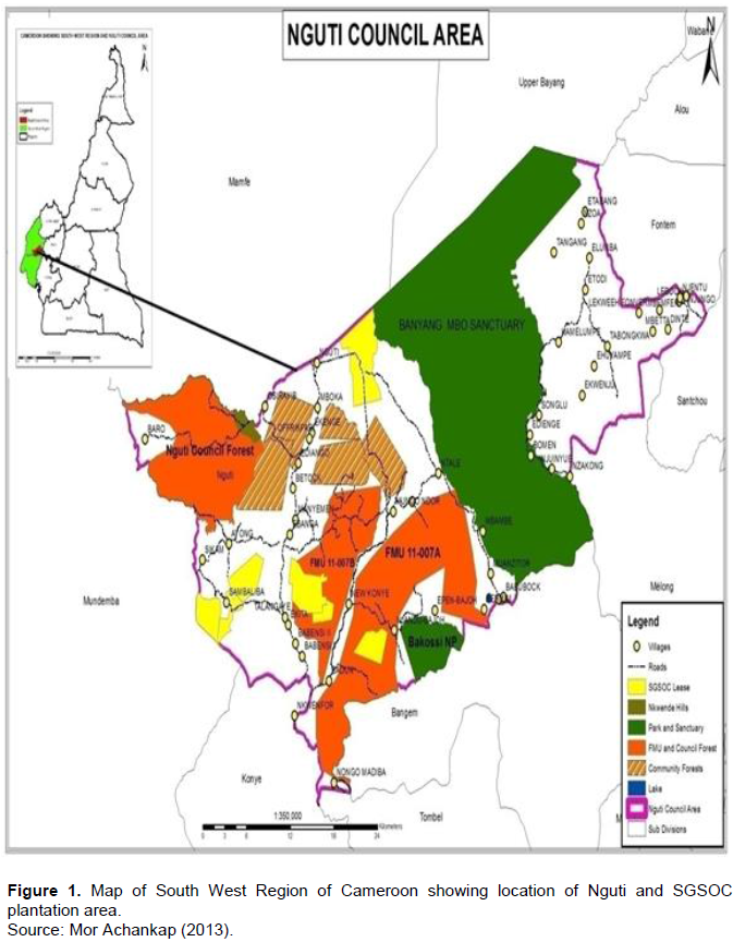
The study was carried out in Nguti subdivision of the KupeMwanenguba Division of the South West Region of Cameroon. It lies between latitude 005.10862 and 005.19782 North and longitude 009.40075 and 009.31609 East (UCCC, 2014). It is surrounded by Mamfe and Upper Bayang in the North, Konye, Tombel in the South, Mundemba in the West and Littoral Region in the East. The area has 56 villages and eight main clans. It has a surface area of 1444 km2 and a population of 67,218 people. The project zone outlined for plantation agriculture is bounded by four protected areas: the Korup National Park, the Banyang-Mbo Wildlife Sanctuary, the Bakossi Forest Reserve and the Nguti Council forest (Figure 1).
Desk study
Extensive review of secondary data was carried out. This was done on published reference books, journals, scholarly articles, internet, in order to have a broader knowledge on the study and inform the theoretical and empirical literature on large-scale plantation agriculture and its impacts on forest cover change and climate variability.
Field surveys
A reconnaissance survey was carried out in the study area in order to get familiarized with the area under study and to choose sampling sites. A trip was made to the concession area and villages were selected based on their closeness to the concession area. Meetings were held with resource persons in villages and other institutions who were directly or indirectly involved in SGSOC.
Data collection and analysis
Land use land cover change, the use of GIS and remote sensing
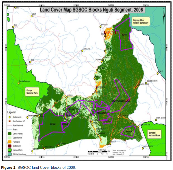
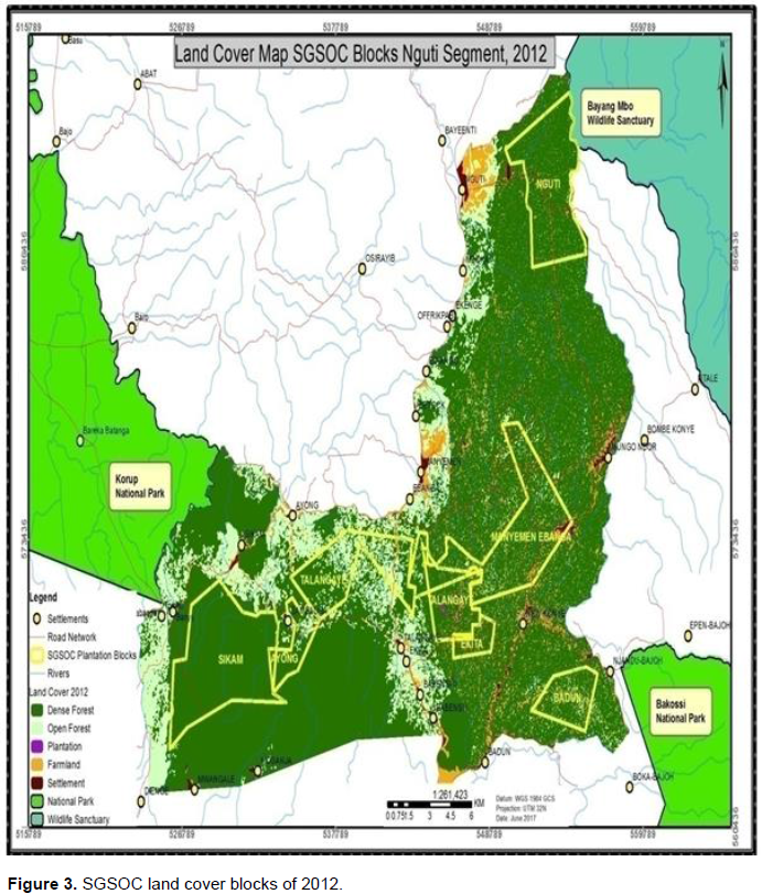
Landsat multispectral images were used to assess land cover change overtime and the effects of such changes on the environment. Satellite images for three different periods; 2006, 2012 and 2015 were used. The 2006 image was used as baseline map before the coming of SGSOC, 2012 to indicate normal variation without the pressure of SGSOC, while the 2015 image was used to show the current land cover change under the influence of SGSOC activities and operation. Satellite images included Landsat 8 OLI + scenes path 187, row 57 for 10th January 2015 and two Landsat 7 ETM + scenes path 187, row 56 for the 10th January 2012and 10th January 2006.
Procedure for data analysis
Land use/land cover
Data was analyzed based firstly on semi-automatic, object-based approach, using segmentations to automatically create polygons and assigning class attributes manually based on a visual interpretation as explained by Tamungang and Bakia (2016). Areas of doubt were marked and later checked in the field through ground-thru thing. Data from previous land cover analysis for South West Regional Delegation of Forestry and Wildlife were obtained from different land cover classes based on expert field knowledge. Classes were obtained from areas that could be identified as dense forest, open forest, plantations, farmlands, settlements. Several plots were constituted where scatter plots, histograms and statistics could be viewed. These plots were then combined to form a single class (dense forest).The following classification procedure was performed:
(i) Initially, an unsupervised classification was performed to get a general over view of the major land cover types in the area,
(ii) Then followed a supervised classification by creating plots using major cover types based on some field data and knowledge from the previous classification,
(iii) The final raster cover map obtained passed through some steps aimed at rendering the pixels more informative and giving a seamless presentation. This includes boundary cleaning and regional grouping.
(a) Land cover class: Pixels generated were vectorized and symbolized to obtain the land cover class for 2006, 2012 and 2015 images.
(b) Land cover change: Attributes of the pixel generated were extracted to generate alphanumeric data to obtain cover class quantification and hectares.
(c) Trend in degradation: The changes in the land use pattern were then compared using Bar charts and percentages to obtain the trend in degradation over nine year’s interval.
Resident’s perception on the impacts of land covers change on climate variability
Two techniques were used to achieve this objective; questionnaires, interviews, and focus group discussions.
Sampling location and respondents
Nine villages fall under the SGSOC concession area but the magnitude to which they are affected by the concession were different. Among the nine villages five (Manyemen, Ebanga, Talangaye, Ekita and Babensi 2) were purposely selected for this study based on the impacts of the concession area on them as read from literature. Respondents were residents aged 25 years who have lived in villages or settlements adjacent to the SGSOC oil palm plantation area for at least eight years. Respondents were randomly selected from four main classes;
(i) Local communities; farmers, forest users (hunters, fishermen, NTFP collectors, traditional doctors), community authorities (Chiefs and traditional councils), women and Youths.
(ii) Government Institutions; Agriculture and Rural Development, Environment and Nature Protection Authorities, Forestry and Wildlife Officers.
(iii) Environmental defenders; Worldwide Fund for Nature (WWF), Wildlife Conservation Society (WCS), Nature Cameroon NGO.
(iv) SGSOC Company; Top Management staff (Authorities) and general labourers (Field supervisors and hourly paid staff).
Questionnaires administration
Questionnaires were administered to the five primary impact villages whose population stands at 7755.388 respondents (5% of the population) from the primary impact villages were randomly selected for questionnaires distribution.
Interviews
Semi-structured interviews were conducted with SGSOC Staff (6 out of 12 Top Management Staff, 6 out of 13 field supervisors, 22 out of 149 hourly paid staff). These interviews were to assess the amount of land already covered by the plantation, further expansion plans and their perceived impacts on the environment. In addition, three interview sessions were carried out with the Chief of Post and staff (2) of the Delegation of Agriculture and Rural Development (MINADER), 2 Staff of Forestry and Wildlife (MINFOF). 28 key informants were interviewed (15 from primary impact villages, 5 from secondary impact villages, 8 from SGSOC cutting across from top management to field staff). Participants for this exercise comprised village heads/Kingmakers, forest management committee members, farmer’s committee members, government representatives including some former workers of SGSOC. The interviews were out to gather information on the perceived impacts of the plantation on local climates.
Focused group discussion
Six focused group discussions were held to get an overview of perceptions on the impacts of the plantation forest cover change and climatic variation around neighboring community’s communities. Participants for these discussions came from different villages with diverse ideas, consisting of village authorities, farmers, hunters, fishermen, non-timber forest products (NTFP) gatherers, traditional doctors and other community members. With the help of village leaders (Chiefs or representatives and traditional council secretaries), the researcher invited participants including men, women and youths alike. Participants for these discussions ranged from 8 to 12 depending on the size of the population. For this exercise, women were separated from men, just like youths were separated from their parents or elderly. The reason for this separation was basically because women in this area are not allowed to speak in the presence of men due to the cultural barrier.
Data analysis
Completed questionnaires and interview guides were cross-checked for data integrity and data cleaning. Data was then coded for analysis along key themes, emerging patterns and consistency. Coding and interpretation was done along key themes to determine its relevance in answering the research questions. The results of the study were presented in the form of tables, pie charts explanatory texts, and summary statistics to show relationships between key variables. Qualitative data analysis was done using Statistical Package for Social Sciences (SPSS) version 21 and Ms Excel version 2013.
Vegetation cover and land use, land cover analysis
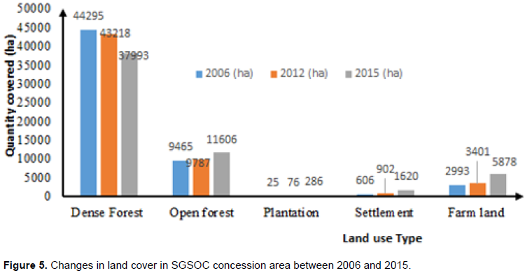
Results from satellite images revealed five land use classes; dense forest, open forest, plantation settlement and farmlands. These land use classes have been change overtime (Figures 2 to 4). Dense forest recorded a decrease of -2.43% (1077 ha) within six years between 2006 and 2012 prior to the intensification of SGSOC’s activities on the ground. Open forest equally recorded a decrease of-3.4% (322 ha) from 2006 to 2012. Plantation surface increased to 76.5 ha in 2012 as opposed to 25 ha in 2006, recording an increase of 67%. The settlement area increased by 33% (295), while farmland witnessed a slight increase by 12% (407 ha) (Table 1).
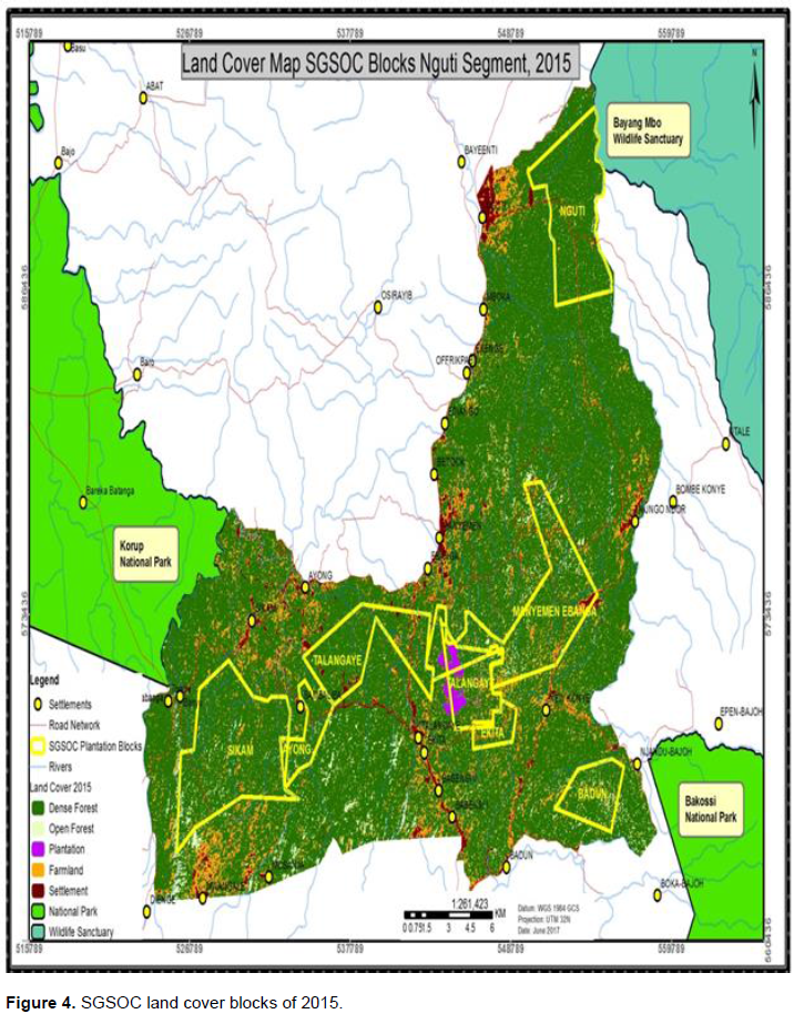
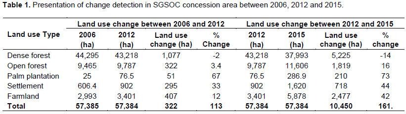
Dense forest reduced by -14% (5,225) between 2012 and 2015. This was the period when SGSOC’s activities were intense leading to a reduction in open forest. Open forest recorded a percentage change of -16% (1,819 ha) from 2012 to 2015. Plantation surface area was at 286.9 ha in 2015 as opposed to 76.5 ha in 2012, recording an increase of 73% (210). The settlement area increased by 44% (718), while farmland witnessed an increase of 42% (2,477) (Figure 5).
Perception on the impact of land use, land cover change on local climate variability
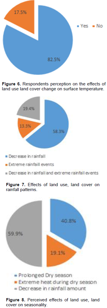
82% of respondents confirmed that there has been an increase in surface temperatures within the past five years while 17% of respondents believed that there has been no change in surface temperatures in the study areas within the same period (Figure 6).
According to respondents, land use land cover change has affected the precipitation pattern in the area through main ways; through decrease rainfall amounts and through extreme rainfall events. 58% of respondents believed that there has been a decrease in rainfall in past few years, 19% believed climate variability is evident in the area through extreme rainfall events while 19% think that the area has experience both decrease rainfall and extreme rainfall events (Figure 7). The effects of seasonality have also been felt in the area. 40% of respondents confirmed that there has been a prolonged dry season within the past few years, 19.1% think there been an increase in dry season temperature while 59% think there been a decrease in rainfall amount with the rainy season (Figure 8).
Dense forest decreased slightly between 2006 and 2012 and further witness a significant decrease (5,225 ha) between 2012 and 2015. This change may be due to a change in land use from forest to large-scale plantation between 2012 and 2015. This is almost similar to the findings of Henson (2013) who pointed out that agriculture and grazing are the major causes of land use, land cover change. In like manner, Abbas and Iguisi (2007) confirmed that agricultural expansion and urbanization have also been identified as the major and proximate causes of land use, land cover change. A reduction in dense forest may have adverse impact on climate and other ecosystem services, since forest provide a diversity of ecosystem services including converting carbon dioxide into oxygen and biomass, acting as a carbon sink, aiding in regulating climate, purifying water, mitigating natural hazards such as floods, and serving as a genetic reserve (Hartemink, 2005).
Open forest witnessed a slight decrease (322 ha) between 2006 and 2012 and tremendous decrease (1,819 ha) between 2012 and 2015. Though other activities have been taking place in this area between 2012 and 2015, the presence of oil palm plantation may have a major influence to the rapid increase in open forest recently. As plantation expands coupled with other factors like population increases, more pressure is exerted on the land for farming to meet up with food demand, construction of new houses and other anthropogenic activities. When this happens, more and more forest is opened leading to fragmentation.
Plantation agriculture takes a different change pattern from dense and open forest but with more pronounced figures. Within the periods of 2006 and 2012, dense forest decreased slightly (51 ha) but between the periods of 2012 and 2015, plantation agriculture increase significantly (210 ha). The reason for this change is that SGSOC intensified their expansion activities between 2012 and 2015. Between 2006 -2012, the surface area of land occupied by plantation was low because they were owned by community members in low scale (0.5 -1 ha), while 2012-2015 witnessed a comparatively rapid expansion because it was large scale due to the presence of SGSOC. As oil palm plantation expands, more land is fragmented due to deforestation and hence, degradation.
In the same pattern as plantation agriculture, farmlands registered a slight increase (12%) between 2006 and 2012 and significant increase by 42% between 2012 and 2015. These changes occurred for two reasons; population increase within these years aggravated the demand for food and consequently opening of more farms. Secondly the creation or expansion of access roads to plantation from foot path to about 10meters opening farm to market roads which encourages more farmers to take up marginal lands for cultivation. Arhem (2011) also highlighted that the creation of farm to market roads can increase agricultural productivity in rural Africa.
Most of the respondents in this study attested that they have experiences climatic variability in many forms such as increase in surface temperatures, a reduction in rainfall and changes in seasonality patterns of the area. Climate variability experienced in the study area is a result of a reduction in forest cover. The loss of canopy exposes the earth to direct heat, which results in an increase in surface temperature. In the open canopy the sun as well as rains directly hit the earth surface which adversely affect the biodiversity and enhance the surface run off and consequently decrease the soil nutrients and biomass (Bargali et al., 1993). The livelihood of indigenous people may in this process be compromised, as they depend on the forest and its resources for their survival directly as a source of food, medicine, and income (Sheil et al., 2009). Evans (1987) also pointed out that the expansion of plantation activities leads to increase in surface temperatures in the neighboring areas since the surface is allowed bare and there are no trees to ameliorate the climatic situation of the area. Changes in seasonal pattern may also lead to significant reduction in farmers output especially peasant farmers. In forest cover in the Nguti division in the South West region of Cameroon. Forest cover witnessed a 1,819 ha reduction between 2012 and 2015, which correlated the period of tremendous increase in plantation agriculture (plantations agriculture increased by 210 ha between 2012 and 2015). This has led to a significant decrease in dense and opened forest. However, the effects of plantation agriculture on changes in land use cannot be over emphasized, as there are also other causes of forest cover change such as increase in buildup areas. Eighty-two of respondents have also attested that there has been variation in the local climatic pattern in the form increase daytime temperature, decrease in rainfall and delay in the coming of rains during the rainy season. Climate variability may have serious impacts on the lives and livelihoods of people in the community especially as communities depend on rain fed agriculture.
There is need for the government to develop a participatory land use scheme in the study area to allocate areas of different land use in other to ensure sustainability and avoid conflict between the population and plantation companies. There is also need for the government to follow up and make sure large-scale plantations implement their environmental management plan. Since communities depend on rain fed agriculture, which is affected by climate variability, there is need for communities to have adapted seeds to cope with the impacts of climatic variability in the area. NGOs working on agriculture, environmental protection agencies and the Cameroon agricultural research institute (IRAD) can provide communities with seeds that can resist climatic variability in the area.
The authors have not declared any conflict of interests.
REFERENCES
|
Arhem K (2011). Environmental consequences of the palm oil industry in Malaysia. Lunds universitets Naturgeografiska institution-Seminarieuppsatser.
|
|
|
|
Bargali SS, Singh RP, Mukesh J (1993). Changes in soil characteristics in eucalypt plantations replacing natural broad leaved forests. Journal of Vegetation Science 4(1):25-28.
Crossref
|
|
|
|
|
Cameroon Tribune (2012). Le gouvernement conduitactuellementuneimportantepolitique de Constitutiondes réservesfoncièresfoncières pour répondreadéquatement à uneemande de plus en plus fortemaisaussimultiformeetvariée. Jacqueline Koungin Bessike, Minister of the Cadastre and Lands ofCameroon, 24th November 2012, P 12.
|
|
|
|
|
Carrere R (2010). Oil Palm in Africa: Past, Present, and Future Scenarios. World Rainforest Movement, Montevideo, Uruguay. Available at
View
|
|
|
|
|
De Schutter O (2012). Mission au Cameroun duRapporteur spécialsur le droit à l'alimentation.
|
|
|
|
|
Evans J (1987). Plantation forestry in the tropics - trends and prospects. The International Tree Crops Journal 4(1):3-15.
Crossref
|
|
|
|
|
Hartemink E (2005). Plantation agriculture in the tropics: Environmental Issues. Outlook on Agriculture 34(1):11-21.
Crossref
|
|
|
|
|
Hulme M, Doherty R, Ngara T, New M, Lister D (2010). African climate change: 1900 2100. Climate Research 17(2):145-168.
Crossref
|
|
|
|
|
Henson IE (2013). The Malaysian National Average Oil Palm: Concept and Evaluation. Journal Article: oil palm Bulletin 46(20):15-27.
|
|
|
|
|
Intergovernmental Panel on Climate Change (IPCC) (2001). Special report on land use, land-use change, and forestry. Summary for policy makers IPCC,
|
|
|
|
|
Johansson M (2008). Sustainable Palm Oil? How does the Indonesian Palm Oil Industry affect Indonesia ecologically, socially and economically? Department of Social and Economic Geography.
|
|
|
|
|
Sheil D, Casson A, Meijaard E, Noordwijkm V, Gaskell J, Sunderland-Groves J, Wertz K, Kanninen M (2009). The Impacts and Opportunities of Oil Palm in Southeast Asia: What do we know and what do we need to know? (Vol. 51). Bogor, Indonesia: Center for International Forestry Research.
|
|
|
|
|
Tamungang R, Bakia MA (2016). Report on Land Cover Change Dynamics in main protected Areas and Key Wildlife Corridors in the Southwest Region, Cameroon. Report for PSMNR-SWR, in partnership with German Cooperation. Deutsche Zusummenarbeit.
|
|