ABSTRACT
Vehicle collisions with wild animals are acknowledged as a non-negligible source of death of wild birds and often affect their spatial-temporal distribution, abundance and diversity. However, data to ascertain the impact of road kills on wild birds are scarce, especially around the Serengeti Ecosystem in Tanzania. This work aims to investigate the impact of road kills on wild birds and their spatial-temporal distribution, abundance and diversity in the Serengeti ecosystem in Tanzania. Five road transects each with a length of 40 km were established within the main roads of the Serengeti ecosystem. Bird surveys were conducted in the morning and afternoon in both wet and dry seasons (March and August 2015), respectively. The study results indicated that, 1472 birds have been inventoried which belong to 42 families, 62 genera and 98 species. Mean number of individual birds was the highest in wooded grassland and species richness was also the highest in grassland habitats. In addition, more birds were observed during the wet than dry season. Birds’ mean abundance was higher during the morning than afternoon, especially in the grassland. In the ecosystem, 31 individual birds belonging to 19 species that were distributed in five families were found killed along the road networks. In the Seronera-Fort Ikoma transect, more bird species were killed in roads with higher traffic volume during the morning than afternoon compared to other transects in the area. On the contrary, the extent of the road kill was the highest in wooded grassland. This study recommends that increased road kills could be regulated within the ecosystem by placing signposts at the entrance and visitors’ centre in conjunction with educational programs to raise road users' awareness on the impact of road kills for biodiversity conservation in the area.
Key words: Birds’ roadkill, traffic volume, richness, distribution, diversity, habitat type, conservation, Serengeti ecosystem.
Although road networks in protected areas are econo-mically important to the society as a whole (Ferraro and Hanauer, 2014; Mahulu et al., 2015); however, they may also have negative impacts on wildlife conservation due to vehicles noises, related disturbances and vehicles collision with wild animals (da Cunha et al., 2010; Garriga et al., 2012). This ismore severe when such road networks cross out protected areas. It is worth mentioning that roads building throughout protected areas do not always have negative significant ecological and environmental effects on terrestrial and aquatic communities. However, road networks can also create new habitats for wildlife as roads retain heat. The latter can contribute to reduce metabolic costs for birds that rest on the road surfaces (Morelli et al., 2014). Regarding the importance of associated road structures, the study of Forman (2000) has reported that poles, culverts and bridges represents key structure for bird’s nesting/resting. In addition, road verges increase availability of food sources that attracts granivore and insectivore types of birds due to the availability of seeds and insects (Lonsdale and Lane, 1994; von der Lippe et al., 2013). Moreover, pot holes along the road can create water points during rainy season, and they often contribute to attract a large number of birds seeking to drink water (Ascensao and Mira, 2006). On the contrary, roads building and road structures are not always beneficial to the society to some extent, especially with regards to biodiversity conservation.
Trombulak and Frissell (2000) reported that protected areas and the existence of roads and vehicle traffic have significant ecological and environmental effects on terrestrial and aquatic communities through ecosystem and habitat fragmentation, and loss of biodiversity in some extent.
Similar results are also driven by anthropogenic activities. Such anthropogenic activities may therefore lead to displacement (spatial distribution) of wildlife population including birds (Kociolek et al., 2011). Birds are known as one of the species that are more sensitive to habitat fragmentation and disturbances. Adapting to its new environment requires that birds might migrate out of the fragmented areas to a relatively less disturbed one. Implementing an effective conservation approach often calls for understanding factors that determine the distribution patterns of birds especially those related to increase of human activities in protected areas. This is because the periodic road maintenance entails habitat destruction and population fragmentation (Senzota, 2012). As a result, its effects on birds can represent high mortalities of birds on roads passing through protected areas (Ramp et al., 2006; Mkanda and Chansa, 2011; Collinson et al., 2014). For the period between 2013 and 2015, the impact of roads on bird mortality was reported to be 50% in Tarangire-Manyara Ecosystem in Tanzania (Kioko et al., 2015). However, the Serengeti ecosystem information on bird diversity, distribution and abundance along roads is scanty. In addition, there is little information on road networks influence on bird mortality patterns. Therefore, this study aims at bridging this gap by documenting spatial and temporal distribution, abundance and diversity of birds around the Serengeti ecosystem. More specifically, this paper aims to:
(1) Assess spatial-temporal distribution, abundance, richness and diversity of birds along roads, and
(2) Assess the extent, rate and factors contributing to birds’ road mortality.
Study area
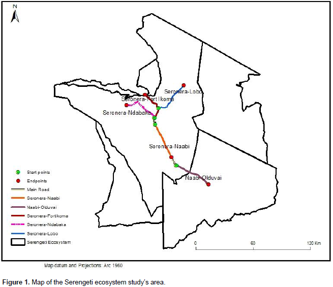
This study was conducted between March and August 2015 in Ngorongoro Conservation Area (NCA) and in Serengeti National Park (SNP), which are parts of the Serengeti ecosystem in the Northern Tanzania. The ecosystem extends to south-western Kenya and between 1015' to 3030' S and 34034' to 360 E. The ecosystem has several protected areas under different management categories including Serengeti National Park (SNP), NCA, Maswa Game Reserve (MGR), Loliondo Game Controlled Area (LGCA) and Ikorongo-Grumeti Game Reserves (IGGRs) in Tanzania, and Maasai-Mara National Reserve in Southern Kenya (Sinclair and Norton-Griffiths, 1979). The study focused on the main roads passing through the NCA and Serengeti National Park (SNP) (Figure 1). The study area receives bimodal rainfall generally lower in the south and east of the ecosystem than in the north and west, with an estimate of 500 mm/year, and 950 to 1150 mm/year of rainfall respectively (Norton-griffiths et al., 1975; Sinclair, 1995). The vegetation cover in SNP is influenced mainly by soil type and rainfall. Such vegetation can be broadly classified into the eastern grass plains, central acacia woodlands, and northern broadleaf forests (Sinclair, 1995). The ecosystem is a home of about 70 larger mammal species (McNaughton, 1985), and that more than 617 bird species have already been identified (Jankowski et al., 2015; Werema et al., 2017).
Data collection
Five road transects were established within the main roads of the Serengeti ecosystem in NCA and SNP. The main road segments were selected based on their relatively high usage by vehicles in the Serengeti ecosystem. The selection criteria included both high and low traffic volume transects of 40 km length each. The categorization of traffic volume was based on the results obtained from vehicle traffic volume per day, and was grouped into two classes. Indeed, transect with >25 vehicle passes/day was considered as high traffic volume transect (that is, Oldupai, Naabi and FortIkoma transects) while transect with <25 vehicle passes/day was considered as low traffic volume (that is, Ndabaka and Lobo transects). The first road transect started from Seronera to FortIkoma (hereof as Fort Ikoma), second transect started from Seronera-airstrip to Naabi gate (Naabi), the third transect started from Naabi gate to Oldupai River in NCA (Oldupai). The fourth transect started from Banagi to Togoro plain (Lobo). The fifth one started from Nyaruswiga hill to Ndabaka (Ndabaka). All the first three roads transect were categorized as high traffic volume while the fourth and fifth ones were classified as roads of low traffic volume. Each road transect was divided into three sections; left-hand edge, center of the road, and right-hand edge. These three sections of the road transect represented the standard road sampling width in which birds were identified and counted. Nine points were established within a road transect at 5 km intervals. At each sampling point, the width of the road was measured and the mean of the width of the road was calculated to obtain a transect width for birds’ observation.
Data collection phases on birds were conducted both in the wet and dry seasons. One transect was surveyed in one day in the morning session starting at 7:30 to around 11:30 am and in the afternoon session, it started from 14:00 to around 18:00 pm. The vehicle was driven at 20 kph or less with stopping to take records of each bird or group of birds encountered (Collinson et al., 2014; Mahulu et al., 2015). A binocular was also used to clearly identify birds. Two observers were seated in a land rover pick-up sighting and recording birds foraging along the roads. Variables such as transect name, global positioning system (GPS) location, time, landscape factors (that is, distance to water sources or bridge), vehicle odometer reading, habitat type and number of birds were recorded at each encounter of bird species. Birds’ activity along the roads (that is, feeding, drinking, resting and crossing), road kills and information on habitat types (that is, woodland, wooded grassland, grassland, riverine, and bushland) were also recorded. To achieve the objective of the study, the following hypotheses were set:
(1) Roads with high traffic volume would decrease birds’ abundance and diversity as well as increase road kill of birds than in low traffic roads. This implies that at high traffic volume, birds have higher probability of colliding with moving vehicles than low traffic volume. In the meanwhile, at high traffic volume, birds tend to avoid foraging along roads due to disturbance which resulted from passing vehicles than low traffic volume,
(2) More birds (live or killed) should be observed during the morning hours compared to evening in the wet than in dry season of the year.
(3) More birds (live or killed) should be observed in areas closer to water sources and bridges (bridges provide nesting and roosting sites and are likely to reserve water during wet season) than in non-water related sources and bridges.
Statistical analysis
Comparisons of birds’ diversity and evenness across transects and activity type
(1) Insectivores (those that feed on arthropods including insects and other arthropods such as spiders and centipedes).
(2) Granivores (birds that feed on herbs and seeds).
(3) Omnivores (birds that feed on herbs, seeds and arthropods), and
(4) Frugivores (birds that feed on fruits).
In addition, birds that feed on other birds, rodents, reptiles, amphibians and fish were classified as vertebrate feeders (that is, raptor, owl and heron). To determine which road had the greatest bird biodiversity, species richness estimates were obtained following
Shannon and Weaver (1998) index. Such index uses four biodiversity indices to appreciate the richness of the species within a given area including, richness, diversity, abundance and evenness. The calculation of such indexes allows one to ascertain which road has the greatest biodiversity community of birds (Hammer et al., 2001). Bird abundance in different roads and time periods were calculated across the nine points established within a road transect, and standard errors were computed. In this case, birds’ abundance was represented by the number of individuals counted in a given area per day.
Determinations of risk factors for birds’ road kill
We fitted a Generalized Linear Mixed Model (GLMM) in order to assess factors responsible for birds road kill. Transect ID, road segment were defined as random effects in the model, while fixed effects variables identified was the number of live mammals recorded, distance from observed animal to nearby bush, water source and bridge, season of survey (wet or dry), road conditions (good and poor), session (morning or afternoon), verge grass colour, and height as well as habitat type. Pearson correlation analysis was used to assess collinearity between predictor variables. The best approximating model was selected from the global model by using Chi-square test (p < 0.05). The significance of excluding or including each predictor variable was evaluated by model update, each time removing one predictor until all possibilities were done, to see if there were predictors that did not cause a significant drop in the goodness of fit of the model. The relative likelihood was evaluated using Akaike Information Criterion (AIC) (Akaike 1973), the small-sample bias adjustment delta AICc (Hurvich and Tsai, 1989). Models were ranked by calculating Akaike weights (w) which ranged from 0 to 1, and considered the subset model with highest weight and delta < 2 as the best approximate model (Burnham and Anderson, 2002).
Spatial-temporal distribution and abundance
In all five road transects surveyed, 1472 individual birds were observed belonging to 42 families, 62 genera and 98 species. For roads with high traffic volume, mean abundance (±SE) of birds was the highest (8.44±1.05) compared to road transects with low traffic volume (5.305±0.64). This means that the Oldupai transect recorded more birds (9.556±2.54) in mean abundance, followed by Lobo transect (9.26±2.2) and Naabi (7.02±1.32). However, no differences in mean abundance of birds were encountered between the two transects of Ndabaka (6.93±1.5) and FortIkoma (6.896±1.49) (Figure 2). Mean birds’ abundance was the highest in wooded grassland compared to other habitats types along all the road transects surveyed. Total mean birds’ abundance was estimated at 11.08±2.53 (Figure 3). The second habitat type with the highest mean birds’ abundance was grassland (8.54±1.52) followed by woodland (7.28±1.41), bushland (3.42±0.74) and riverine (2.0±0.44) habitats.
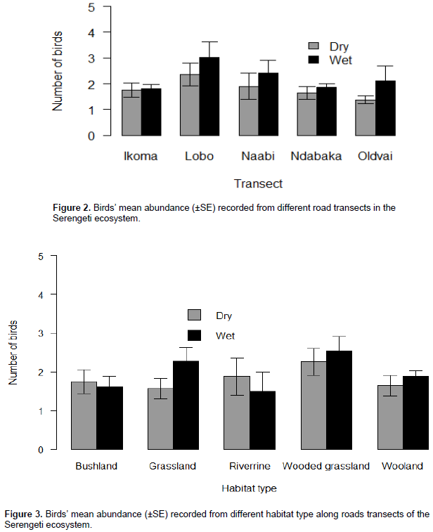
The riverine represents the habitat type that has the least important mean birds’ abundance out of the five habitat types (Figure 3). More birds were observed during morning hours than afternoon, and the highest bird mean (±SE) was recorded during morning hours (33.95±1.76) than during afternoon hours (24.58±0.89). The overall species abundance during morning and afternoon differed significantly across the road networks. Morning observations (Z = 7.03, P = 0.0002) differ significantly from those of the afternoon. More birds were observed during wet season in March (Z = -3.098, P = 0.0019) with mean abundance of 25.47±2.009; the lowest was observed during the dry season in July (Z = -6.821, P = 0.0009) and August (Z = -3.098, P = 0.0002) with mean abundance of 11.75±1.48. The difference was statistically significant.
Richness and diversity of birds along roads
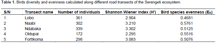
Species richness of birds differs among road transects. A significant difference was found between species richness of birds in Ndabaka (Z = -3.931, P = 0.0001) and Naabi road transect (Z = -3.649, P = 0.0003) but not with other road transects in the Serengeti ecosystem. In Ndabaka road transects, the highest number of species (53) was encountered followed equally by FortIkoma and Naabi with 43 bird species each. Lobo (39) and Oldupai (18) represent the two surveyed road transects that have the least number of species out of the five roads transects sampled. In addition, species richness of birds in grassland (Z = 2.909, P = 0.0036), wooded grassland (Z = 7.612, P = 0.0002) and woodland (Z = 4.940, P = 0.0008) differ significantly from other habitats type. The result shows that the highest species was in grassland (57) followed by wooded grassland (49), woodland (47), bushland (24) and riverine (9) bird species. The results from Generalized Linear Mixed Models (GLMM) revealed that the presence of bridge and water sources away (>10m) from the roads have an influence on birds’ abundance, diversity and distribution along the roads of the Serengeti ecosystem. In terms of birds' diversity, Ndabaka had the highest diversity of bird species (H' = 3.302) and the least species diversity was observed in Oldupai (H' = 2.295) (Table 1). The evenness of birds in all road transects surveyed did not reach complete evenness. The overall evenness for five roads transects was generally relatively low (Table 1).
Birds’ road kill and activities patterns along the roads
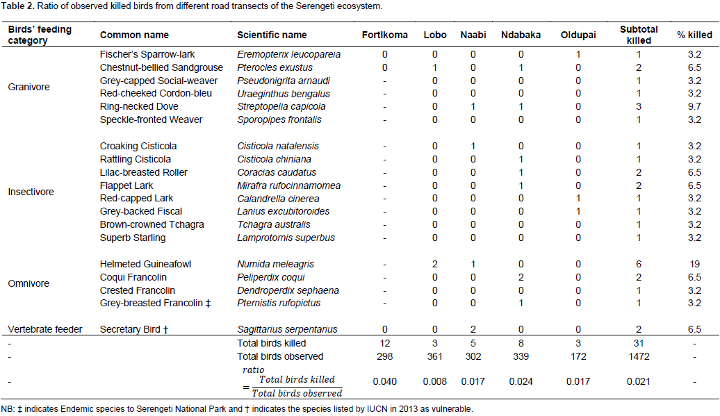
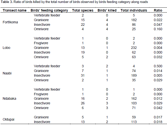
In all surveyed road transects, 31 individual birds were killed along the roads with an average of two species being killed per day. The highest number of road kills was observed in the morning (19 individuals) and the lowest in the afternoon (12 individuals). The FortIkoma transect had more kills with 12 (38.7%) bird species followed by Ndabaka transect with 8 (25.81%) bird species killed. Naabi transect had 5 (16.13%) killed bird species followed by Lobo and Oldupai transects which had 3(9.68%) birds species killed. In all the road transects surveyed, only Naabi Road contributes significantly to road kill (Z = -1.979, P = 0.048) out of the other road transects surveyed. Wooded grassland and woodland habitats are among the habitats where most bird species were killed; the birds species killed belonging to Guineafowl Numida meleagris (Helmeted) with the highest percentage were estimated at 19% followed by Streptopelia capicola (Ring-necked Dove) (9.7%) (Table 2). In all the road transects surveyed, birds were observed foraging along the roads. Feeding, crossing from one side of the road to another and resting on roads surface were the main activities carried out by birds. Birds that flew away from the road before observers identified their activities were as an ‘unidentified activity’ and were omitted in the analysis. The result on birds' activities patterns along roads show that feeding (36 species) was the main activity performed by birds. Twenty-four bird species were observed crossing and 11 species were resting on roads. Granivore and insectivore were among the most abundant and diverse type of birds encountered in the study area (Table 3).
Factors influencing birds’ mortality
The proportion of bird road kill was higher in the dry than in the wet season. However, model results retained five factors such as the number of animals, distance to water >50m, vehicle speed > 40 km/h, season (wet), lane width >7.5m and distance to bridge >50m. Such variables have either a highly and significant influence on road bird mortality as shown by the Generalized Linear Mixed Models (Table 4).
Spatial-temporal distribution and abundance of birds along roadsides
Regarding abundance and richness of bird species, the results of this study did not support our first hypothesis stating that roads with high traffic volume would decrease birds abundance and diversity. We found that high abundance and bird species richness in roads with high traffic volume indicate larger number of some specialized population of birds, particularly granivore (queleas, bishops, widowbirds and whydahs) and insectivorous (that is, larks, plovers and wheatears). In those roads, the availability of food has certainly attracted bird species (Kociolek and Clevenger, 2009).
This means that roadside provides certainly useful foraging habitats to birds sources of food, nesting sites, habitat quality (effect of landscape heterogeneity), good hiding locations to avoid predators, and marginal habitats (ecological corridors) as optimal foraging birds’ habitat. On the contrary, the occurrence of birds along the roadsides could be attributed to how the landscape and traffic volume were structured across the study area. Since field observations have revealed that the studied roads traversed patchy vegetation types and verge conditions therefore such structures have certainly driven a non-uniform distribution of birds along the respective roads. According to the following scholars, Li et al. (2010), Summers et al. (2011) and Morelli et al. (2014), the mean abundance of birds declined during the dry season as a result of the decrease in spatial gradient of the landscape characteristics such as vegetation productivity, reduction of food availability and sometimes low quality of nesting sites for perching birds or songbirds (Passeriformes). Moreover, the abundance of birds along roadsides might also be driven by the fact that they tend to visit roads to warm up their bodies’ temperature from heating road surface. Such practice has also been evidenced elsewhere because it is very important to reduce bird metabolic expenditures, except during dry season (van der Ree et al., 2011).
Richness and diversity of birds along roads
The highest species richness and diversity of birds was observed in Ndabaka and FortIkoma transects due certainly to habitat heterogeneity (woodland, wooded grassland, riverine, grassland and bushland) encountered along the roadside. Such habitat heterogeneity has certainly attracted birds to forage along these road transects. The relatively low evenness observed for five road transects surveyed demonstrated that the noise of passing vehicles possibly affected the population of birds. The population of birds could have been certainly impacted by noise disturbances and/ or dust produced by passing vehicles, along with injury and/or kill of birds. Although 98 species of birds have been recorded in all five transects of this study, they did not reach or exceed quarter of the 617 species that are known throughout the entire Serengeti ecosystem (Nkwabi et al., 2011; Jankowski et al., 2015). This may suggest that passing vehicles along the roads could have slightly affected the distribution of birds in their ecosystem. Although the data analysed is from short term observations (during the dry and wet seasons of a single year), the results show that the observed bird species along the roads included some importantly threatened bird species like Bateleur (Terathopius ecaudatus), Fischer's Lovebird (Agapornis fischeri) and Kori Bustard (Ardeotis kori) species. These species have been listed by IUCN as Near Threatened in 2012.
Similarly, the Secretary Bird (Sagittarius serpentarius) have been listed by IUCN as Vulnerable in 2013 (IUCN, 2016). Roadside habitats attracted the mentioned birds to forage; as a result, birds are exposed to high levels of traffic noise, visual disturbance from passing vehicles, and the risk of collision. The study survey has also revealed existence of Grey-breasted Francolin (Pternistis rufopictus) along Serengeti roads the endemic species to the ecosystem exposing to risk of vehicle collision. Bird activities’ patterns such as feeding, resting, crossing and other activities performed were frequently observed during the wet season, especially in the morning. All activities were mostly recorded in woodlands and wooded grassland. These results supported our second hypothesis that more birds’ activities occur along the road in the morning and during the wet season of the year. A possible explanation is that granivore and insectivore types of birds often visit woodland and wooded grassland for possibly supplementing their diets in food sources such as seeds and insects along road verges (Laursen, 1981; Laurance et al., 2004). The model run out indicated that landscape factors such as location of roads, habitat type and verge grass characteristics caused a significant direct influence on birds’ distribution, abundance and diversity. Birds’ distribution was also associated with the distance of 20-50m and >50m and not close from the bridges and water sources.
Such results are opposite to our third hypothesis that states that “more birds should be observed in areas close to water sources and bridges”. This is explained by the behaviour of birds which select foraging sites by considering quality and quantity of the availability resources needed (Cody, 1981). In terms of roadkill, the results showed that, a distance of 20 to 50 m and greater than 50 m to bridge was highly significant instead of the close distances to bridge (0 to 10 m). This indicates that more birds were killed at longer distances away, not very close or even at zero distances to bridges. Furthermore, increased road kill of Ring-necked Dove and Helmeted Guineafowl could be attributed to an increased feeding activity of these birds on seeds and dead insects as road kill that might be available along roads. The latter point could make more of these birds be exposed to collision with vehicles (Lambertucci et al., 2009; Husby, 2017). Presence of vertebrate feeders (Bateleur, Secretary Bird, Amur Falcon Falco amurensis, Greater Kestrel Falco rupicoloides, Lesser Kestrel Falco naumanni and Montagu's Harrier Circus pygargus) that use road surfaces as hunting substrate (capturing preys or taking advantage of roadkill) suggests that road surface and roadside in the study transects had frequent incidences of dead animals.
Birds’ road kill and activities patterns along the roads and opportunities to improve birds’ conservation around the Serengeti ecosystem, Tanzania
The study results suggest that, in protected areas, birds are exposed to different factors that may lead to their mortality.These factors include those which are related to traffic especially vehicle speed and road lane width. We found that road mortality was associated with high vehicle speeds. These results are in line with previous findings (Aresco, 2005; Rao and Girish, 2007) that reported the severity of invertebrate/insect casualties on road. In addition, the study results have indicated that some road features also affect bird mortality which is in line with Laurance et al. (2009). In tropical rainforests, they found that linear infrastructures building up such as roads, highways, power lines and gas lines are sources of vulnerability of tropical species that are susceptible to road kill. In addition, roads have a major role in opening up forested tropical regions to destructive colonization and exploitation of tropical species. For example
Goosem (1997) found that wider road widths (which possibly encourage higher speed among drivers) and long distances from bridges in roads (which possibly reduce driver carefulness) were significantly associated with road mortality of birds and concur previous findings.
Results confirm that distance to water source is another factor of road birds’ mortality; this is in line with
Baskaran and Boominathan (2010), who reported more road kills on highway stretches that were close to rivers than those located away from water sources. However, the fact that this study indicated more bird road mortality occurred at distances greater than 50 m indicated distances within 50m are probably too close to influence road kill. In the wet season, more birds possible forage along road areas because of food availability (Laurance, 2004; WiÄ…cek et al., 2015). Thus increasing exposure to vehicles collision could be the reason for the high association between bird mortality and wet season and the number of birds recorded. The mortality of endangered bird species was listed by IUCN as Vulnerable (IUCN, 2016), especially the
Secretary Bird. According to
Burkey (1989),
Allentoft and O’Brien (2010) and
Senzota (2012), road mortality could contribute to local extinction of bird species.
CONCLUSION AND RECOMMENDATIONS
This study has contributed to find that mean birds’ abundance was the highest in wooded grassland than in other habitats types along all surveyed transects. This means that roadside provides certainly useful foraging habitats as source of food, nesting sites, habitat quality, good hiding locations to avoid predators, and marginal habitats for birds. Thus, the bird communities appear to be changing in response to human activities occurring along the roads with changes in the structure of birds’ habitats. In terms of roadkill, individual birds were killed along the roads with an average of two species per day.
The followings are suggested:
(1) Carrying out conservation efforts to integrate the critical factors of road kill in the design and implementation of mitigation measures to reduce road kill incidences in Serengeti ecosystem in Tanzania by removing roadside use of underpasses, signboards, and speed breakers can help to minimize road kill of animals;
(2) Establishing a monitoring program in order to identify road stretches with high road kill “potential” as well as species at high risk of being killed to set up targeted mitigation actions;
(3) Carrying out monitoring protocols such as longitudinal survey to establish base line data on the taxonomic group of the species that are more vulnerable by quantifying road mortalities and/or determining key habitats.
The authors have not declared any conflict of interests.
We thank the Management of Tanzania National Parks (TANAPA), Ngorongoro Conservation Area Authority (NCAA) and the Tanzania Wildlife Research Institute (TAWIRI) for permission to conduct this study. We are grateful especially to Messrs. Onesmo Mwakabejela and Habibu Muna for their assistance in the fieldwork. In addition, we extend our sincere thanks to Mr. Machoke Mwita and Mr. John Sanare of TAWIRI for preparing the map of our study area. Fund for this research was provided by TAWIRI.
REFERENCES
|
Allentoft ME, O'Brien J (2010). Global amphibian declines, loss of genetic diversity and fitness: a review. Diversity 2:47-71.
Crossref7
|
|
|
|
Aresco MJ (2005). Mitigation measures to reduce highway mortality of turtles and other herpetofauna at a north Florida lake. J. Wildl. Manag. 69:549-560.
Crossref
|
|
|
|
|
Ascensao F, Mira A (2006). Spatial patterns of road kills: a case study in southern Portugal. In: Proceedings of the 2005 International conference on ecology and transportation. Irwin, CL, Garrett, P and McDermott, KP (Eds). Center for Transportation and the Environment, North Carolina State University, Raleigh, North Carolina pp. 641-646.
|
|
|
|
|
Baskaran N, Boominathan D (2010). Road kill of animals by highway traffic in the tropical forests of Mudumalai Tiger Reserve, southern India. J. Threat. Taxa. 2:753-759.
Crossref
|
|
|
|
|
Burkey TV (1989). Extinction in nature reserves: the effect of fragmentation and the importance of migration between reserve fragments. Oikos 55:75-81.
Crossref
|
|
|
|
|
Burnham KP, Anderson DR (2002). Model selection and multimodel inference: a practical information-theoretic approach. Springer Science & Business Media.
|
|
|
|
|
Cody ML (1981). Habitat selection in birds: the roles of vegetation structure, competitors, and productivity. BioScience 31:107-113.
Crossref
|
|
|
|
|
Collinson WJ, Parker DM, Bernard RT, Reilly BK, Davies-Mostert HT (2014). Wildlife road traffic accidents: a standardized protocol for counting flattened fauna. Ecol. Evol. 4:3060-3071.
Crossref
|
|
|
|
|
da Cunha HF, Moreira FG, Silva SS (2010). Roadkill of wild vertebrates along the GO-060 road between Goiânia and Iporá, Goiás State, Brazil. Biol. Sci. 32:257-263.
Crossref
|
|
|
|
|
Ferraro PJ, Hanauer MM (2014). Quantifying causal mechanisms to determine how protected areas affect poverty through changes in ecosystem services and infrastructure. Proceed. Natl. Acad. Sci. 111:4332-4337.
Crossref
|
|
|
|
|
Forman RTT (2000). Estimate of the area affected ecologically by the road system in the United States. Conserv. Biol. 14:31-35.
Crossref
|
|
|
|
|
Fry CH, Keith S (2004). The birds of Africa Volume VII. Sparrows to buntings. Christopher Helm, London.
|
|
|
|
|
Fry CH, Keith S, Urban EK (2000). Birds of Africa Volume VI. Picathartes to Oxpeckers. Academic Press, San Diego, California.
|
|
|
|
|
Garriga N, Santos X, Montori A, Richter-Boix A, Franch M, Llorente GA (2012). Are protected areas truly protected? The impact of road traffic on vertebrate fauna. Biodivers. Conserv. 21:2761-2774.
Crossref
|
|
|
|
|
Goosem M (1997). Internal fragmentation: the effects of roads, highways, and powerline clearings on movements and mortality of rainforest vertebrates. Tropical forest remnants: ecology, management, and conservation of fragmented communities. University of Chicago Press, Chicago. pp. 241-255.
|
|
|
|
|
Hammer Ø, Harper DAT, Ryan PD (2001). PAST: paleontological statistics software package for education and data analysis. Paleontol. Electron. 4:9.
|
|
|
|
|
Husby M (2017). Traffic influence on roadside bird abundance and behaviour. Acta Ornithol. 52:93-103.
Crossref
|
|
|
|
|
International Union for Conservation of Nature (IUCN) (2016). The IUCN Red List of Threatened Species. Version 2016-3 Retrieved 17 January, 2017.
|
|
|
|
|
Jankowski JE, Sinclair ARE, Metzger KL (2015). Bird Diversity of the Greater Serengeti Ecosystem: Spatial Patterns of Taxonomic and Functional Richness and Turnover. In: Serengeti IV: Sustaining biodiversity in a coupled human-natural system. Sinclair, ARE, Metzger, KL, Mduma, SAR and Fryxell, J (Eds). University of Chicago Press, Chicago. pp. 359-393.
|
|
|
|
|
Kioko J, Kiffner C, Jenkins N, Collinson WJ (2015). Wildlife roadkill patterns on a major highway in northern Tanzania. Afr. Zool. 50:17-22.
Crossref
|
|
|
|
|
Kociolek AV, Clevenger AP (2009). Effects of Paved Roads on Birds: A Literature review and recommendations for the Yellowstone to Yukon Ecoregion. Western Transportation Institute, College of Engineering, Montana State University.
|
|
|
|
|
Kociolek AV, Clevenger AP, St Clair CC, Proppe DS (2011). Effects of road networks on bird populations. Conserv. Biol. 25:241-249.
Crossref
|
|
|
|
|
Lambertucci SA, Speziale KL, Rogers TE, Morales JM (2009). How do roads affect the habitat use of an assemblage of scavenging raptors? Biodivers. Conserv. 18:2063-2074.
Crossref
|
|
|
|
|
Laurance SG (2004). Responses of understory rain forest birds to road edges in central Amazonia. Ecol. Appl. 14:1344-1357.
Crossref
|
|
|
|
|
Laurance SG, Stouffer PC, Laurance WF (2004). Effects of road clearings on movement patterns of understory rainforest birds in central Amazonia. Conserv. Biol. 18:1099-1109.
Crossref
|
|
|
|
|
Laurance WF, Goosem M, Laurance SG (2009). Impacts of roads and linear clearings on tropical forests. Trends Ecol. Evol. 24:659-669.
Crossref
|
|
|
|
|
Laursen K (1981). Birds on roadside verges and the effect of mowing on frequency and distribution. Biol. Conserv. 20:59-68.
Crossref
|
|
|
|
|
Li Z, Ge C, Li J, Li Y, Xu A, Zhou K, Xue D (2010). Ground-dwelling birds near the Qinghai-Tibet highway and railway. Transp. Res. D Transp. Environ. 15:525-528.
|
|
|
|
|
Lonsdale W, Lane A (1994). Tourist vehicles as vectors of weed seeds in Kakadu National Park, Northern Australia. Biol. Conserv. 69:277-283.
Crossref
|
|
|
|
|
Mahulu A, Senzota R, Magige F (2015). Diversity of large mammals along the proposed road across Northern Serengeti, Tanzania. J. Zool. Biosci. Res. 2:18-24.
|
|
|
|
|
McNaughton S (1985). Ecology of a grazing ecosystem: the Serengeti. Ecol. Monogr. 55:259-294.
Crossref
|
|
|
|
|
Mkanda F, Chansa W (2011). Changes in temporal and spatial pattern of road kills along the Lusaka-Mongu (M9) highway, Kafue National Park, Zambia. S. Afr. J. Wildl. Res. 41:68-78.
Crossref
|
|
|
|
|
Morelli F, Beim M, Jerzak L, Jones D, Tryjanowski P (2014). Can roads, railways and related structures have positive effects on birds?–A review. Transp. Res. D Transp. Environ. 30:21-31.
|
|
|
|
|
Nkwabi AK, Sinclair ARE, Metzger KL, Mduma SAR (2011). Disturbance, species loss and compensation: Wildfire and grazing effects on the avian community and its food supply in the Serengeti Ecosystem, Tanzania. Austral Ecol. 36:403-412.
Crossref
|
|
|
|
|
Norton-Griffiths M, Herlocker D, Pennycuick L (1975). The patterns of rainfall in the Serengeti ecosystem, Tanzania. Afr. J. Ecol. 13:347-374.
Crossref
|
|
|
|
|
Ramp D, Wilson VK, Croft DB (2006). Assessing the impacts of roads in peri-urban reserves: Road-based fatalities and road usage by wildlife in the Royal National Park, New South Wales, Australia. Biol. Conserv. 129:348-359.
Crossref
|
|
|
|
|
Rao RSP, Girish MS (2007). Road kills: Assessing insect casualties using flagship taxon. Curr. Sci. pp. 830-837.
|
|
|
|
|
Senzota R (2012). Wildlife mortality on foot paths of the University of Dar es Salaam, Tanzania. Trop. Ecol. 53:81-92.
|
|
|
|
|
Shannon CE, Weaver W (1998). The mathematical theory of communication. University of Illinois press, Chicago.
|
|
|
|
|
Sinclair ARE (1995). Serengeti past and present. In: Serengeti II: Dynamics, Management, and Conservation of an Ecosystem. Sinclair, ARE and Arcese, P (Eds). University of Chicago Press, Chicago. pp. 3-30.
|
|
|
|
|
Sinclair ARE, Norton-Griffiths M (1979). Serengeti: Dynamics of an Ecosystem. University of Chicago Press, Chicago.
|
|
|
|
|
Summers PD, Cunnington GM, Fahrig L (2011). Are the negative effects of roads on breeding birds caused by traffic noise? J. Appl. Ecol. 48:1527-1534.
Crossref
|
|
|
|
|
Trombulak SC, Frissell CA (2000). Review of ecological effects of roads on terrestrial and aquatic communities. Conserv. Biol. 14:18-30.
Crossref
|
|
|
|
|
van der Ree R, Jaeger JA, van der Grift E, Clevenger A (2011). Effects of roads and traffic on wildlife populations and landscape function: road ecology is moving toward larger scales. Ecol Soc. 16:48.
Crossref
|
|
|
|
|
von der Lippe M, Bullock JM, Kowarik I, Knopp T, Wichmann M (2013). Human-mediated dispersal of seeds by the airflow of vehicles. Public
|
|
|
|
|
Werema C, Nahonyo CL, Kibaja M (2017). The role of kopjes in bird species' conservation within an agricultural matrix west of the Greater Serengeti Ecosystem, Tanzania. Scopus 37:8-23.
|
|
|
|
|
WiÄ…cek J, Polak M, Filipiuk M, Kucharczyk M, Bohatkiewicz J (2015). Do birds avoid railroads as has been found for roads? Environ. Manag. 56:643-652.
Crossref
|
|