ABSTRACT
Humans and wildlife interact negatively, especially when humans transform natural wildlife habitats by establishing settlements and crop fields. Encroachment and habitat fragmentations caused by human activities decrease habitat size and quality for wildlife and reduce connectivity among protected areas. The major objective was to quantify economic loss inflicted by wildlife species to local communities in terms of crop and livestock losses. The influence of distance from the boundary of the protected area was also assessed. 240 copies of open and closed ended questionnaire were randomly administered in five selected villages in the Rungwa-Katavi Corridor between the Rungwa Game Reserve and Katavi National Park. The average loss to wildlife per household was 430 kg of crops, equivalent to US $126.23, as well as livestock, including cattle (0.9), goats (0.6), sheep (0.3), and donkeys (0.09) equivalent to US $260.23 per household per year. The reported incidences of crop damage and livestock attack varied among different age groups and between genders. The depredation and crop raiding incidences increased with proximity to the protected areas as contact with predators and vermin animals was higher closer to the protected areas. Implementing proper land use planning for livestock keepers, crop production and conservation land is recommended as an effective strategy to safeguard protected areas and minimize human-wildlife conflict.
Key words: Human-wildlife conflict, crop damage, livestock depredation, Rungwa Game Reserve, wildlife corridor.
Transformation of wildlife habitats into croplands, settlements and grazing lands for livestock increasingly threatens the future survival of wild animals in areas surrounding protected areas in Tanzania and the rest of the world; protected areas are becoming islands (Akenden, 2015; Woodroffe, 2000). According to the United Nations list of world protected areas, protected areas covered a total area of 32,868,673 km2 worldwide in 2014, which accounts for 14% of the terrestrial world land area and 3.4% of the marine protected area network (Deguignet et al., 2014). Approximately, 65% of the global protected area network sites are in Europe. However, they account for only 12% of the total area covered by protected areas worldwide. Africa has fewer sites of protected areas, but these sites account for 13.8% of the total area covered by the global protected area’s network (Juffe-Bignoli et al., 2015). The largest terrestrial protected area in the world is found in Greenland. The Republic of Tanzania is well known for setting aside approximately 45% of its land as protected areas under different categories such as National Parks, Game Reserves, Forest Reserves, Wildlife Management Areas, and Game Controlled Areas (IUCN, 2017; TNRF, 2008).
The fragmentation and loss of habitat facing many protected areas is exacerbated by the rapidly growing human population. Tanzania’s human population has increased from approximately 7 million in 1961 to approximately 45 million in 2012 (URT, 2013). With an annual growth rate of 3.1%, Tanzania’s population is projected to reach 69.1 and 129.1 million in 2025 and 2050, respectively (PRB, 2013). More than 80% of the country's population depend on small scale agriculture and livestock as their major livelihood strategies. According to the population census of 2012, more than 75% of the Tanzanian human population are young, below the age of 35 years; most are unemployed and reside in areas that are also wildlife habitats or corridors, thus blocking wildlife movements from one protected area to another (Caro et al., 2009; Hariohay and Røskaft, 2015).
Humans and wildlife interact adversely when wildlife disperses from core protected areas (PAs) through the premises of local communities. In such cases they destroy crops, depredate on livestock and pose a threat to human security. Such interactions cause negative attitudes towards wild animals and their conservation (Nyahongo, 2007). Other negative impacts are the increase in time spent in guarding farms and livestock and other infrastructures such as water sources (Shemweta and Kideghesho, 2000).
Areas currently used by humans were historically used by wild animals as habitats, especially when they are moved from one protected area to another (Caroet al., 2009). The negative human-wildlife interactions were minimal because the human population was low; consequently, demand for settlements, agricultural and grazing lands was low. Over the last several decades, human population growth has led to increased encroachment on dispersal areas and wildlife corridors, causing small, non-continuous patches of habitats. Opening of new agricultural fields and nomadic pastor.
Nomadic pastoralism are traditional farming methods used by local communities in the villages surrounding most protected areas in Tanzania and are detrimental to future existence of these protected areas (Kideghesho, 2015). The impact of human beings on wildlife is not well understood, but the disturbance to wild animals creates stress, which might affect their ability to reproduce (Tingvold et al., 2013).
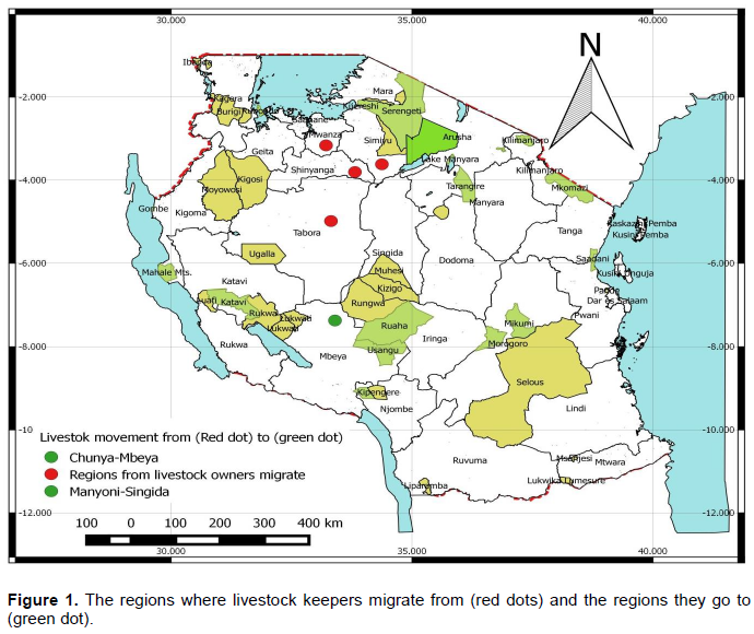
Among the dominant livestock owners in Tanzania are the people of the Sukuma tribe. Increasing conversion of land to settlements and croplands and impacts of climate change have forced movement of these people further South to Rungwa-Katavi from Shinyanga, Tabora, Simiyu, and Mwanza regions (Figure 1). This movement has subjected the area to rapid human population increase and therefore anthropogenic activities such as land clearing to open up fields, charcoal burning, timber, settlements and overgrazing leading to habitat deterioration (Caro et al., 2009; Hassan, 2003; Kideghesho et al., 2006). These activities have adversely affected the Rungwa-Katavi Wildlife Corridor, which is ecologically important for large mammals including African elephants (Loxodonta africana), African wild dogs (Lycaon pictus), hartebeests (Alcelaphus buselaphus), impala (Aepyceros melampus), greater kudus (Tragelaphus strepsiceros) and lesser kudu (Tragelaphus imberbis). As in other areas of Tanzania, the pressure to degazette the protected areas to allow other human uses has increased in Rungwa-Katavi in recent years. However, the question is: what will occur if such areas do not exist? Some have argued that this would provide suitable grazing land for livestock keepers. Establishing and implementing proper land use and management strategies at the village level will avoid unnecessary conflicts between livestock owners and protected area management and enhance sustainable conservation of wildlife resources.
Objectives
The main aim of this study was to assess the economic loss inflicted by wildlife species to local communities living in the Rungwa-Katavi wildlife corridor, connecting the Rungwa Game Reserve and the Katavi National Park.
The specific objectives were:
(1) to identify the cost of livestock and crop damage by wildlife in the study area; (2) to assess the relationship between crop and livestock damage to distance from protected area.
Two hypotheses were tested: first, there is no significant loss caused by wildlife to crop and livestock in the study area and secondly, there is no significant difference between livestock depredations and crop damage with the distance to the protected area.
Study area
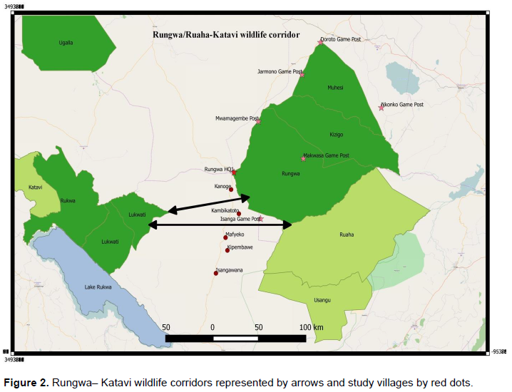
The Rungwa-Katavi Wildlife Corridor connects the Rungwa/Kizigo/ Muhesi Game Reserves in the east and on the western side of Katavi National Park with the Lukwati/Piti and Rukwa/Lwafi Game Reserves (Figure 1). The Rungwa-Ruaha Ecosystem is the second stronghold, after the Selous-Mikumi Ecosystem, for a large population of African elephants (TAWIRI, 2014). The corridor covers an area of 9,378.58 km2 located in the east between S 6.97421, E 33.51251 and S 7.80476, E 33.83169 and in the west between S 7.71328, E 33.50591 and S 7.16871, E 32.70056. The corridor comprises the area between the Matandala and Mbanga Mountains, which is a water catchment that supplies the Lukwati Game Reserve and the Mwipa and Mwise Rivers feeding into the Rungwa River. From the west, elephants move from the top of the Lake Rukwa Escarpment, along the Lukwati River, and then on to the Mwipa and Mwise Rivers and northwards to the Piti and Rungwa Rivers during the dry season. Similarly, elephant movements occur from Ruaha National Park and Rungwa Game Reserve to the east towards the Mwaliji/Lueja Rivers during the dry season (Jones et al., 2012).
People residing in this area are agro-pastoralist reliant on farming and beekeeping as their major social economic activities. Tobacco, sesame and sunflower are cultivated as cash crops, whereas maize, beans and millet are major food crops. Most of the immigrants practice both crop cultivation and livestock keeping, while the residents mostly depend on crop cultivation and few depend on beekeeping and selling bee honey as source of household income. The main ethnic groups include Kimbu, Nyamwezi, Sukuma, Fipa, Nyakyusa, Safwa, Gogo, Sangu, Nyaturu, and Taturu. The others, such as Kurya and Haya, are in minority.
Experimental
A total of 240 respondents were randomly selected and interviewed from five villages. Villages were grouped into two categories: (1), those in proximity to the boundary of the Game Reserve (Kanoge and Kambikatoto) and (2) the villages further away from the Game Reserve (Isangawana, Kipembawe and Mafyeko) (Figure 2). In each village, 48 copies of the questionnaire were randomly administered to respondents, aged 18 years and above. The researcher worked from the village centres, where he randomly stopped people for interview. The researcher then moved to the next centre with a high concentration of people. Several questions were asked aimed at gathering information about their interactions with wildlife, as well as the demography and socio-economic activities of the respondents. The other part of the questionnaire contained questions on crop damage incidences, types of wildlife responsible, livestock depredations incidences, type of predators responsible and mitigation measures used.
Statistical analyses
Quantitative data were processed and analysed using Statistical Package of Social Science (SPSS) version 19.0. Descriptive statistics were used to generate means and percentages, which are important for comparison purposes. Chi-square tests were used to determine the significant differences among the research results. Non-parametric statistics were mostly used when data were not normally distributed. The significance level was set at p < 0.05. Finally, linear regression or logistic regression analyses was used to test the most influential factors.
Social-demographic variables of the respondents
The 240 respondents included both males (68.8%) and females (31.2%). The majority of respondents were in the 37 to 55 years age group (48.3%), followed by 18 to 36 years (32.5%) and above 55 years (19.2%). 61.2% of the respondents had attended primary school, while less than 1.3% had been to secondary school and 37.5% were illiterate. Two-thirds (66.7%) of the respondents were indigenous and 33.3% were immigrants. The main socioeconomic sources of income were crop cultivation (64.6%), followed by livestock keeping (31.2%) and employment/business (4.2%). A majority of the respondents (60%) came from distant villages, and only 40% lived close to the protected area. 12.9% of respondents had no dependants, while 6.7% had >10 dependants, 27.5% had 5 to 10 dependants, and 52.9% had <5 dependants.
Livestock ownership
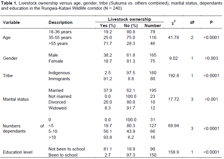
Out of 240 respondents, only 32.1% owned livestock. Most of the livestock owners owned 62 cattle (80.5%), while a minority owned 8 goats (10.4%), 4 sheep (5.2%) and 3 donkeys (3.9%). There was a significant increase in livestock ownership with age, as the majority of livestock owners were in the >55 years age category, followed by those in the 37 to 55 age category, with the least livestock owners in the 18 to 36 age category (Table 1). Most of the livestock owners were immigrants; very few were from the indigenous group (Table 1).
The majority of the respondents who had not been to school owned livestock, while very few of who had been to school owned livestock, with a statistically significant difference (Table 1). There was a significant difference between married and unmarried respondents in terms of livestock ownership, as most of those who owned livestock were married and only a few who were not married owned livestock (Table 1).
Livestock ownership significantly varied with the number of dependants, as those respondents with no dependants did not own livestock. Livestock ownership increased with the number of dependants respondents had: respondents with <5 dependants owned few livestock, followed by respondents with 5 to 10 dependants; more than 90% of respondents with >10 dependants owned a large quantity of livestock (Table 1).
Livestock depredation
More than half of the livestock owners (54.5%, N = 77) had experienced livestock depredations. Depredation incidences varied with distance from the PA, as most respondents close to the PA (81.5%) experienced depredation, while 40.0%, of the respondents from distant villages reported fewer depredation cases; this difference was statistically significant (Table 2). Livestock depredation varied significantly between male and female respondents, as more males reported more depredation incidences than females (Table 2). Depredations reports varied with tribe, as the Sukuma tribe reported a higher livestock depredation incidence than all of the other tribes combined (Table 2).
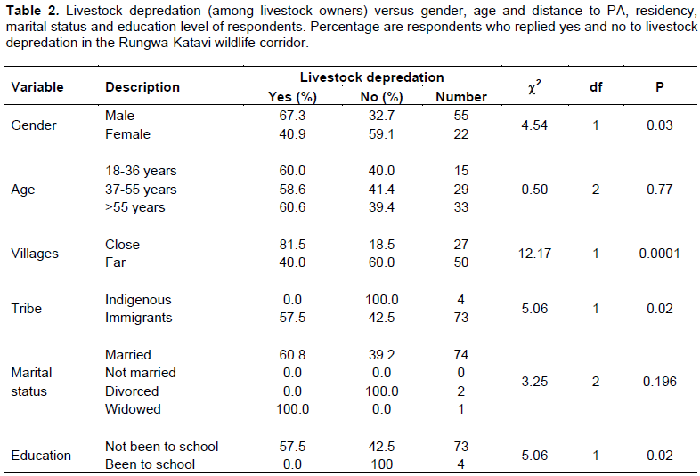
Additionally, depredation incidences varied with education level, as more of those who had not attended formal education reported depredation incidences than those who had attained formal education (Table 2). However, depredation incidences did not differ between any of the groups, including age and marital status (Table 2).
Livestock killed and economic loss
Respondents estimated the average loss of killed livestock per person per year to be 1.9 animals (N = 43). Cattle were most often reported as killed by depredation (55.8%). Other livestock killed included goat (25.6%), sheep (11.6%), and donkey (7%). In the local markets where this study was conducted, cattle are sold at an average price of US $250/animal: goats and sheep are sold at an average price of US $30/animal and donkeys were sold at an average price of US $60/animal.
A total of 83 livestock were recorded killed, which included 39 cattle, 26 goats, 14 sheep, and 4 donkeys, equivalent to an average of 0.9, 0.6, 0.3, and 0.09 animals killed, respectively, per year per household. In monetary terms, cattle contributed greatest the economic loss (US $226.74), followed by goats (US $18.14), sheep (US $9.77) and donkey (US $5.58) per year to the households that reported depredation incidences. The total economic loss caused by livestock depredation in this study is about US $11,190.00, which is an average of US $260.23 per year per household.
Type of predator
Spotted hyenas was the most common predator, reported to cause 53.5% (N = 23) of the depredation incidences, followed by lions (25.6%, N = 11) and leopards (20.9%, N = 9). The frequency of type of predator and livestock killed varied statistically significantly; lions attacked only cattle (100.0%, N = 16), while hyenas attacked mostly cattle (44.4%, N = 18), followed by goats (38.9%, N = 18) and donkeys (16.7%, N = 18); finally, leopards attacked goats (44.4%, N = 9) and sheep (55.6%, N = 9) (c2 = 40.68, df = 6, P < 0.0001).
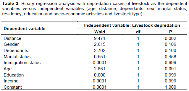
A binary logistic regression using livestock loss (yes/no) as a dependent variable and the distance to PA, gender, marital status, age, residency (immigrant or not), education level, number of dependants, and number of livestock killed as independent factors. Distance from PA was the only statistically significant factor and explained the 53.1% variation in livestock depredation incidences (Table 3). The other independent variables did not explain any of the variation (Table 3).
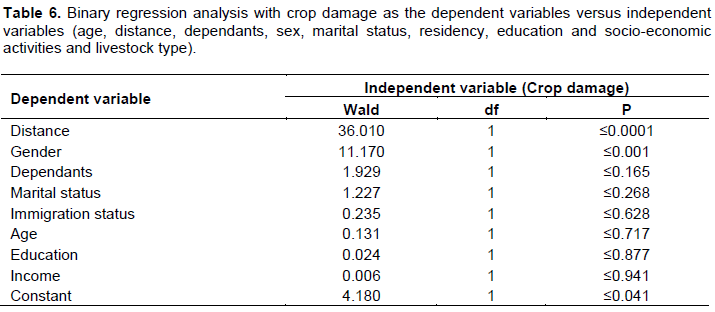
Crop damage
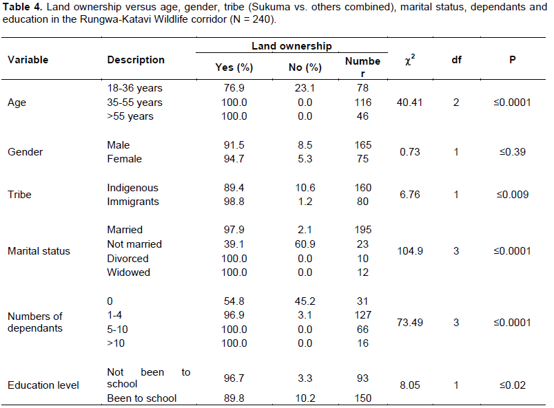
The majority (92.5%) of the respondents owned a piece of land and were peasants (Table 4). The most common crop grown was maize (60.4%); the other types (39.6% combined) included sunflower, beans, sesame, groundnut and tobacco. Land ownership variation was statistically significant with age; respondents 18 to 36 years owned less, while all respondents in the 37 to 55 age group and the above 55 years group owned land (Table 4).
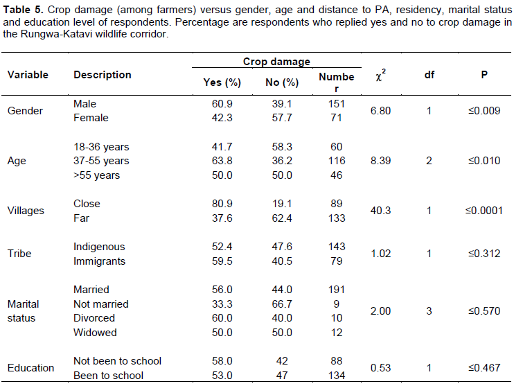
Approximately 45.9% of the peasants experienced crop damage (Table 5). There was a significant difference between close and distant villages, as respondents close to the PA experienced more damage than those far away (Table 5). Reported crop damage incidences varied with the age of the respondents (Table 5). Respondents in the 37 to 55 years age category reported the most crop damage incidences, followed by the >55 years age group; the 18 to 36 years’ age group reported less crop damage incidences (Table 5). The gender of respondents varied significantly in terms of reporting crop damage; more males reported crop damage incidences than female respondents (Table 5). Reported crop damage incidences did not differ significantly between any of the other groups, including education, tribe and marital status (Table 5).
Crop damaged and economic loss
The most commonly damaged crop was maize (97%). The average loss included 417 kg of maize, which is equivalent to US $125 per year per household. Other crops accounted for an average loss of 13 kg per year per household, which is equivalent to a loss of US $1.30 per year per household. Respondents ranked the problem animals causing crop damage. Elephant was the most problematic animal (96.1%) followed by warthog (2.9%) and greater kudu (1%).
Measures to control problem animals
More than three-quarters of the respondents (76.7%) reported controlling problem animals by guarding (25.8%) and scaring by lighting fires and making noises (57.5%). Other strategies cited by 16.7% of the respondents included farming away from the borders of the PAs, growing crops such as pepper that are undesirable to wild animals, or smearing dirty oil on raised poles along the borders of the field.
A binary logistic regression analysis was performed with crop damage incidences as the dependent variable and with the same independent variables as for livestock depredation. The 33.1% variation in crop damage was best explained by distance from the PA and gender (Table 6). Other variables including education, tribe, age, marital status, and crop type were not important variables in explaining the variation in crop damage (Table 6).
Connectivity between Wildlife Protected Areas has been an important topic for discussion for many scholars to maintain genetic flow and biodiversity stability (Weldon, 2006). Considering that many protected areas cannot accommodate populations of mega wildlife such as the African elephant and African wild dogs with large home ranges, wildlife corridors are important for facilitating species movement from one protected area to another. Today, many human-wildlife conflicts are caused by people who are encroaching on these corridors, which had previously been used by wild animals as habitats or stepping stones. Blockage of corridors and dispersal areas for wild animals caused by a rapid human population increase has resulted in the transformation of more wildlife habitats to croplands (Kideghesho et al., 2013, Watkins et al., 2003).
In this study, most of the respondents were males, which are attributed to the fact that males were more free and ready to talk to the researcher than females. All age groups were well represented. However, over 48% were between 37 and 55 years old. This age group owned livestock and agricultural land. Most of the respondents were growing crops for food and keeping livestock as their major source of income. Other sources of income included beekeeping and formal employment in tourist companies operating in the nearby protected areas. Kideghesho (2015) and Kideghesho et al. (2013) reported that dependency on small-scale farming and livestock keeping as major sources of income is common among the villages in areas bordering the protected areas in Tanzania. Researchers were interested mostly in the farmers and livestock keepers, as these groups are the ones incurring the costs of wildlife conservation from livestock depredation and crop damage.
Livestock depredation
Most livestock owners had experienced losses by various predators such as lions, hyenas and leopards as predicted in the first hypothesis. The edge effect theory can best explain why most of the large predators such as lions and hyenas require large home ranges; therefore, encroachment into wildlife habitats created small patches of habitats that increased the chances of predators attacking livestock (Nyahongo, 2007). More than 50% of the respondents mentioned spotted hyena as the leading predator, followed by lions and leopards. This might be explained by the fact that the Ruaha-Rungwa ecosystem has large populations of large carnivores and by the occurrence of encroachment of the livestock keepers and settlements near the borders of these protected areas. For example, a study by Kideghesho (2010) in the western Serengeti corridor indicated that spotted hyena was the most problematic predator, responsible for approximately 98% losses of livestock near the national park boundary. Additionally, spotted hyena can walk long distances, up to 20 km, in a single night and hide in small patches of forest in the village around the human settlement. Similar to our findings, Mwakatobe et al. (2013), reported the spotted hyena as the major livestock-killing predator in the western Serengeti ecosystem.
Reported depredation incidences varied with the distance from the protected area, with more reports from respondents living close to the PA, thus supporting our first hypothesis that impact varies with distance. The findings around Tarangire National Park by Hariohay and Røskaft (2015) and in the Serengeti by Mwakatobe et al. (2013) support our results, as they reported more livestock depredations near the PA than in distant villages. These results therefore support our first hypothesis. Mostly males complained about livestock depredation, which is attributed to the fact that men are responsible for herding cattle in African pastoralist societies such as the Sukuma. Therefore, they experienced more incidences of livestock attacks than females, corroborating the results of Treves and Karanth (2003).
According to respondents, the amount of losses incurred in terms of the number of livestock lost and the price in the local market was economically significant; this supported our second hypothesis: we expected crop and livestock losses in the study area. Economic loss of livestock was estimated to be US $260.23 per year per household in the five villages in and around the corridor. The reported incidences of livestock depredation by hyenas and lions occurred mostly at night and are attributed to poorly built livestock “bomas” using tree poles. Most of the respondents justified their choice of not building strong and permanent buildings to keep their livestock in overnight by reasoning that they do not expect to live there for many years. The majority of the livestock owners in the area (Sukuma) had the habit of moving from one locality to another when the area becomes unsuitable for crop cultivation and the quality and quantity of pasture for their livestock decline. Generally, no proper protection measures have been taken by the livestock owners; most of the time, young boys (under 16 years old) had been looking after large herds of cattle during the day with temporary buildings for livestock during the night. Many of them depended on dogs; others employed a night watchman to guard their livestock premises, similar to what was reported by Lyamuya et al. (2016).
Crop damage
Most of the peasants in the area were victims of wild animals, as their crops had been destroyed by problem animals. More crop damage occurred in the villages close to PA. This is because villages close to the boundary of the wildlife protected areas face the most contact with wildlife such as elephants and other vermin species. Mwakatobe et al. (2014) had similar findings in the western Serengeti, as the crop damage happened at farms closest to the protected area. Most of the crop fields bordered the Rungwa Game Reserve. Crop damage took the form of trampling by elephants. Mfunda and Røskaft (2011) reported crop damage by problem animals in the western Serengeti and their findings support our results in that elephants caused more damage to crops such as maize, sunflower and groundnuts than other animals.
Respondents ranked elephants as the primary problem animal, causing over 90% of the crop damage. The damage occurs mostly during the night. Other animals such as the greater kudu caused crop damage at early stages of plant growth (tender) and destroyed crops mostly during the day; thus, the farmers could guard their crop fields, unlike during the night. An average of 430 kg of various crops was lost per household, which accounts for a significant amount of household income in the villages studied. The estimated amount was from the 222 households who had farmed in the study year. However, the most frequently lost crop type was maize, up to 417 kg; this was attributed to the fact that it was the most commonly cultivated crop. Research in the western Serengeti corridor by Kideghesho (2010) indicated crop losses to have accounted for about US $516 per household higher than our result of US $126.23 per household per year. The difference might be due to the difference in time when the two studies were conducted and fact that majority of communities living adjacent to the western Serengeti corridor are agro-pastoralist and wildlife migrate in that area. The crop losses caused by elephants and other wild animals are among the reasons for poverty among local people and exacerbate unsustainable wildlife conservation in the wildlife corridor. Kideghesho et al. (2007) and Adams et al. (2004) discussed the importance of biodiversity conservation benefiting local communities for the success of sustainable conservation of wildlife, and Bandara (2005) noted that habitat fragmentation is the primary source of conflict between elephants and human beings. Both our first and second hypotheses were supported: first that people faced negative impacts in terms of crop damage in the corridor and second that the crop damage incidences varied with the distance from the Rungwa Game Reserve.
CONCLUSION AND RECOMMENDATIONS
Crop raids and livestock depredation were directly influenced by the distance from the game reserve boundary. The findings supported our hypotheses: first, the negative interactions in terms of crop and livestock losses in the study area and second, that livestock depredation and crop damage occurred more often in villages close to the protected areas. Important factors that influenced crop damage incidences among respondents included age, gender and distance from the PA. Important factors that influenced reporting livestock depredations included gender, education, immigration status and distance from the protected area. It was found that among the immigrants, the Sukuma tribe (91.3%) reported the most livestock depredations.
It was found that livestock keepers lost an average of 1.9 animals to predators per household per year in the study area. The majority of livestock lost were cattle, followed by goat, sheep and donkey. The study recorded farmers to have incurred significant losses of crops, mainly maize (417 kg). Most livestock losses were incurred by the immigrants, but immigrants and residents incurred crop losses equally. This supported our first hypothesis that wildlife had caused significant livestock and crop losses in the study area.
It was recommended that the responsible wildlife authorities should provide education on control measures to prevent problem wild animals such as elephants from destroying their crop farms to reduce the economic losses incurred. Construction of strong bomas and herding practices are recommended to reduce the levels of livestock depredation. Also, it was recommend that communities around the Rungwa Game Reserve should avoid growing crops close to protected areas, as incidences of crop raiding by wild animals and livestock depredation increase towards the protected area boundary. The legislation should recognize wildlife corridors to increase their conservation status; Ministry of Natural Resources and Tourism (MNRT) should identify all remaining corridors that can be given conservation status and restrict anthropogenic activities that are ecologically destructive.
The authors have not declared any conflict of interests.
REFERENCES
|
Adams WM, Aveling R, Brockington D, Dickson B, Elliott J, Hutton J, Roe D, Vira B, Wolmer W (2004). Biodiversity conservation and the eradication of poverty. Science 306:1146-1149.
Crossref
|
|
|
|
Akenden Z (2015). Human- wildlife conflict; The case of elephant at Mole National Park Trondheim: NTNU.
|
|
|
|
|
Bandara R (2005). The economics of human-elephant conflict (unpublished manuscript).
|
|
|
|
|
Caro T, Jones T, Davenport TRB (2009). Realities of documenting wildlife corridors in tropical countries. Biol Conserv.142:2807-2811.
Crossref
|
|
|
|
|
Deguignet M, Juffe-Bignoli D, Harrison J, MacSharry B, Burgess ND, Kingston N (2014). United nations list of protected areas. Cambridge, UK.
|
|
|
|
|
Hariohay KM, Røskaft E (2015). Wildlife induced damage to crops and livestock loss and how they affect human attitudes in the Kwakuchinja Wildlife Corridor in northern Tanzania. Environ. Nat. Resour. Res. 5:56-63.
Crossref
|
|
|
|
|
Hassan SN (2003). Impacts of space use by humans on the large mammal species diversity in the Kwakuchinja - Mbungwe wildlife corridor, northern Tanzania. Tanz. J. For. Nat. Conserv. 76:134-143.
|
|
|
|
|
Jones T, Bamford AJ, Ferrol-Schulte D, Hieronimo P, McWilliam N, Rovero F (2012). Vanishing wildlife corridors and options for restoration: a case study from Tanzania. Trop. Conserv. Sci. 5:463-474.
Crossref
|
|
|
|
|
Juffe-Bignoli D, MacSharry B, Bingham H, Deguignet M, Kingston N (2015). World database on protected areas user manual. Cambridge, UK.
|
|
|
|
|
Kideghesho JR (2010). Wildlife conservation and local land-use conflicts in the western Serengeti corridor, Tanzania. In: Conservation of natural resources; Some African & Asian examples. Trondeim: Tapir academic press. pp. 130-154.
|
|
|
|
|
Kideghesho JR (2015). Realities on deforestation in Tanzania: trends, drivers, implications and the way forward http://dx.doi.org/10.5772/61002. In: Precious Forests - Precious Earth. Web of science: INTECH Open Science/Open minds
Crossref
|
|
|
|
|
Kideghesho JR, Nyahongo JW, Hassan SN, Thadeo C, Mbije NE (2006). Factors and ecological impacts of wildlife habitat destruction in the Serengeti ecosystem in northern Tanzania. Afr. J. Environ. Assess. Manag. 11:17-32.
|
|
|
|
|
Kideghesho JR, Rija AA, Mwamende KA, Selemani IS (2013). Emerging issues and challenges in conservation of biodiversity in the rangelands of Tanzania. Nat. Conserv. 6:1.
Crossref
|
|
|
|
|
Kideghesho JR, Røskaft E, Kaltenborn BP (2007). Factors influencing conservation attitudes of local people in Western Serengeti, Tanzania. Biodivers. Conserv. 16:2213-2230.
Crossref
|
|
|
|
|
Lyamuya RD, Masenga EH, Fyumagwa RD, Mwita MN, Røskaft E (2016). Pastoralist herding efficiency in dealing with carnivore-livestock conflicts in the eastern Serengeti, Tanzania. Intl. J. Biodivers. Sci. Ecosyst. Serv. Manag.12:202-211.
Crossref
|
|
|
|
|
Mfunda IM, Røskaft E (2011). Wildlife or crop production: the dilemma of conservation and human livelihoods in Serengeti, Tanzania. Intl. J. Biodivers. Sci. Ecosyst. Serv. Manag. 7:39-49.
Crossref
|
|
|
|
|
Mwakatobe A, Nyahongo JW, Ntalwila J, Røskaft E (2014). The impact of crop raiding by wild animals in communities surrounding the Serengeti National Park, Tanzania. Intl. J. Biodivers. Conserv. 6:637-646.
Crossref
|
|
|
|
|
Mwakatobe A, Nyahongo JW, Røskaft E (2013). Livestock depredation by carnivores in the Serengeti Ecosystem, Tanzania. Environ. Nat. Resour. Res. 3:46-57.
|
|
|
|
|
Nyahongo JW (2007). Depredation of livestock by wild carnivores and illegal utilization of natural resources by humans in the Western Serengeti [PhD]. Trondheim, Norway: Norwegian University of Science and Technology. World Population Sheet. Washington, DC, 2013; www.prb.org
|
|
|
|
|
Shemweta DTK, Kideghesho JR (2000). Human-wildlife conflicts in Tanzania. Proceedings of the 1st University Wide Conference 5th - 7th April 2000, Tanzania.
|
|
|
|
|
TAWIRI (2014). Aerial census of large animals in the Selous - Mikumi Ecosystem, Dry season, 2013, population status of African elephant. Arusha, Tanzania.
|
|
|
|
|
Tingvold HG, Fyumagwa R, Baardsen LF, Rosenlund H, Bech C, Røskaft E (2013). Determining adrenocortical activity as a measure of stress in African elephants (Loxodonta africana) in relation to human activities in Serengeti ecosystem. Afr. J. Ecol. 51:580-589.
Crossref
|
|
|
|
|
Treves A, Karanth KU (2003). Human-carnivore conflict and perspectives on Carnivore management worldwide. Conserv. Biol.17:1491-1499.
Crossref
|
|
|
|
|
URT (2013). Population and housing census counts 2012. Dar es Salaam.
|
|
|
|
|
Watkins RZ, Chen J, Pickens J, Brosofske KD (2003). Effects of forest roads on understory plants in a managed hardwood landscape. Conserv. Biol. 17:411-419.
Crossref
|
|
|
|
|
Weldon AJ (2006). How corridors reduce Indigo bunting nest success. Conserv. Biol. 20:1300-1305.
Crossref
|
|
|
|
|
Woodroffe R (2000). Predators and people: using human densities to interpret declines of large carnivores. Anim. Conserv.3:165-173.
Crossref
|
|