Full Length Research Paper

ABSTRACT
The land suitability analysis and mapping were carried out using a geographic information system and multi-criteria approach for scaling chickpea (Cicer arietinum L.) varieties in Ethiopia. Therefore, the biophysical variables of climate, topography, and soil were considered for suitability analysis. The environmental factors’ layers of chickpea varieties pixel values were classified and given a rate and ranked. The suitability criteria layers were assigned weights to account for their relative importance. The study's objective was to develop a suitability map for chickpea (C. arietinum L.) varieties using a geographic information system and multi-criteria evaluation approach. Based on the suitability analysis, Desi chickpea varieties Mastewal, Naatolii, Teketay and Arerti, Habru, Kasech, and Yelbey Kabuli chickpea varieties are classified as highly suitable that cover 0.67, 0.71, 1.4, 2.3, 1.3, 2.4 and 1.2 million hectare of the country, respectively whereas moderately suitable areas for the same varieties cover 25.2, 11.3, 25.9, 26.4, 26.6, 9.6, and 17.1 million hectare. The suitability analysis results showed that the currently available improved varieties of chickpea could be targeted for scaling out improved technologies in the identified land suitability classes in the country. The study's findings can be used for policy and decision-making processes to ensure the efficient use of land resources.
Key words: Biophysical, policy, decision-making, land resources, Desi, Kabuli.
INTRODUCTION
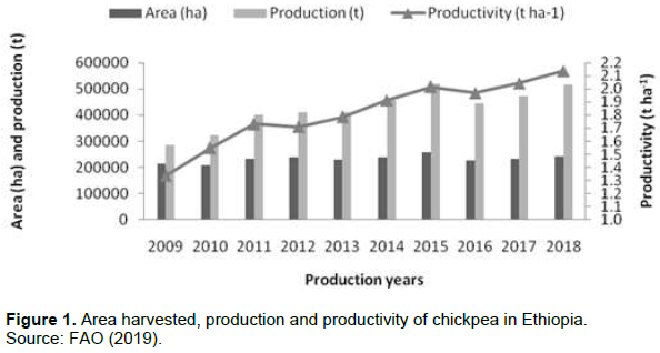
Ethiopia is the largest chickpea producer in Africa and ranking sixth globally (http://ethioagp.org/chickpea/). On average, chickpea production globally consists of about 75% of Desi and 25% Kabuli types (AAFC, 2004). According to FAO (2019), chickpea area, production, and productivity have increased between 2009- 2018, respectively (Figure 1). Variation in cultivated chickpea is primarily noted in the separation of the Kabuli and large-seeded and the desi small-seeded gene pools, each with associated patterns of the traits (Moreno and Cubero, 1978). The Desi types have seed sizes generally in the range of 100-250 g/1000 seed (van der Maesen, 1973). There are small-seeded Kabuli types of 250-350 g/1000 seed, but the large-seeded Kabuli range from 400 to 600 g/1000 seed, with owl’s head-shaped and generally cream-colored seeds and white flowers (Moreno and Cubero, 1978).
Chickpea varieties released between 1990 and 2000 in Ethiopia showed an increase in seed weight of 31.9% and 12% for Kabuli and Desi, respectively. Remarkable progress has been achieved in genetic gain for seed size in the chickpea-breeding program. Because of the primary focus on developing large-seeded Kabulis due to world market demand (Bekele et al., 2015). Seed size is an essential quality trait for Kabuli types as larger seeds fetch a higher premium price in international trade (Gaur et al., 2007).
The existence of diverse farming systems, agro-ecologies, and socio-economic and cultural diversity have endowed Ethiopia with a biological wealth of species diversity, particularly the crops (IBC, 2007).Crop yields are inevitably affected by many factors such as weather conditions, farming practices, input use, amount and prices (fertilizers, seeds), and use of irrigation (CSA, 2015). Agriculture is a source of food and income, but where, when, how, and what to cultivate are the main issues farmers and land managers face daily (Mokarram et al., 2010). Appropriate decision-making on crop production can reduce various risk factors associated with unsustainable land management. The limited available arable land is taken for granted, which may turn from ‘best’ to ‘worst’ irrespective of land use and management practice without understanding its particular requirements and potential use (FAO, 1993; Biradar et al., 2019).
Land suitability classification for agriculture is fundamental for future planning to help decision-makers and agricultural development planners determine how appropriate use of the land in a location are more suitable for certain agricultural use (Singha and Swain, 2016).
Geographic Information System (GIS) has contributed to the speed and efficiency of the overall planning process in agricultural land use suitability. It enables quick and efficient access to large amounts of information, exhibiting relationships, patterns, and trends useful in monitoring land use potential and suitability evaluation. It is a useful tool for scaling proven technologies and practices, including the specific crops and crop varieties, to address the yield and nutritional gaps (Singha and Swain, 2016; Low et al., 2018). As crop’s environmental requirements vary from variety to variety, it is recommended to undertake variety-specific analysis and mapping to understand better the extent of scaling up the specific crop technology (Nigussie, 2014).
The objective of the study was to develop a suitability map for chickpea (Cicer arietinum L.) varieties using the Geographic Information System (GIS) and Multi-Criteria Evaluation (MCE) approach.
MATERIALS AND METHODS
Geospatial data used
The main biophysical factors used in the generation of the suitability map were: rainfall, temperature, length of growing period (LGP), soil type, soil chemical and physical properties, altitude and slope. The rainfall and temperature (during the growing period) interpolated (predicted values for cells in a raster from sample data points) at a spatial resolution of about 300 m which were then resampled to 200 m to match the 200 m analysis resolution. The LGP from the Ministry of Agriculture (WBISPP, 2004) was used with a slight modification (that is, joining the values of dependable length of period and converting to raster (pixel-based). The soil types data were acquired from MoA modified by the Woody Biomass Inventory and Strategic Planning Project (WBISPP, 2004); while, the soil properties ([chemical (pH) and physical (depth, texture, and drainage)], were extracted from the Soil and Terrain Database of East Africa and gridded soil database of 250 m (ISRIC, 2015). For the altitude information, the Shuttle Radar Topography Mission (SRTM) 90 m digital elevation model (DEM) database (Jarvis et al., 2008) was used, and the same DEM used for generating slope map. These data were re-sampled to a common spatial resolution of 200 m for the spatial analysis in the GIS domain. Whereas administrative boundaries and infrastructure (roads, towns, and other facilities) were used to compute statistical information and prepare the final maps, respectively. However, park and lake areas were excluded (restricted) in this land suitability analysis.
Defining environmental requirements
The land suitability class threshold determined were mainly based on (FAO, 1984, 2007) employing a multi-criteria evaluation technique that integrates major determinant factors that affect chickpea production in Ethiopia. The national variety trials conducted at multi-locations and multi-seasons were used to define various suitability ranges/limits.
Then, environmental requirements of each variety were defined by means of a set of critical values, which determine the limits between the land suitability levels (classes) that reflect the degree of suitability (Table 1).
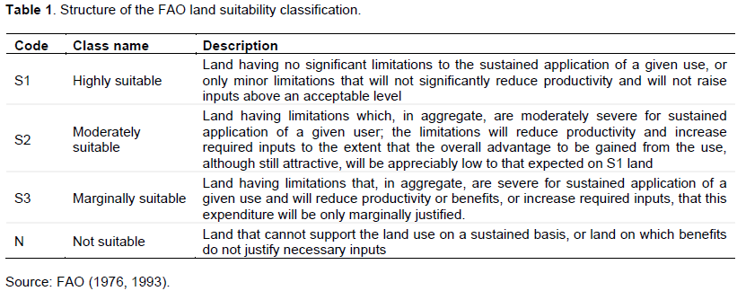
According to FAO classification, S1 corresponds to 85-100% of optimum yield under the recommended management practices, S2 to 60-85%, S3 to 40 - 60%, N1 to 25 - 40% and N2 to 25 - 0% (Elsheikh and Abdalla, 2016).
Since the analysis is raster (pixel) based, some of the data in vector format (object-based) were converted to uniform raster datasets. The necessary GIS layers of environmental factors affecting the growth of chickpea varieties were identified, and each layer’s pixel values were classified and assigned weight.
Following this, the environmental factor layers were compared among themselves and ranked. Based on the rate and rank assigned to each pixel, the land suitability map for each variety was computed. The classification of each layer into suitability categories was done using Reclassify by Table function in ArcGIS spatial analyst (ESRI GIS package) tool. The reclassification is implemented in the model by preparing separate tables for each factor/criteria layer and chickpea variety.
Criteria layers and overall suitability analysis
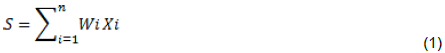
The overall suitability map combines the altitude, slope, soil types, soil properties, and climate layers. The weighted overlay approach built on ArcGIS Model Builder was used for the overlay analysis to solve such multi-criteria problems of suitability. The suitability criteria layers were assigned weights to account for their relative importance and overlaid using the weighted overlay tool to produce the overall land suitability map. The purpose of weighting is to express the relative importance of each factor regarding the effects on crop production (Perveen et al., 2007). The analytic hierarchy process (AHP) was used to evaluate and calculate the weights for the different criteria (Saaty, 2008), and numerical scales of measurement were derived by comparing against the goal for importance. The pair wise comparison scales were assigned through discussion among experts. The overall suitability is computed by multiplying the selected criteria weight (Wi) by the assigned sub-criteria score (Xi) and summing these values in the ArcGIS Model Builder (Equation 1):
Where S denotes the final land suitability score, Wi denotes the weight of the corresponding suitability criteria, Xi denotes the assigned sub-criteria score of (i) suitability criteria, and (n) is the total number of criteria maps. The final suitability result (maps and tabular data), including the explanatory document, is prepared in softcopy and hardcopy.
Crop varieties
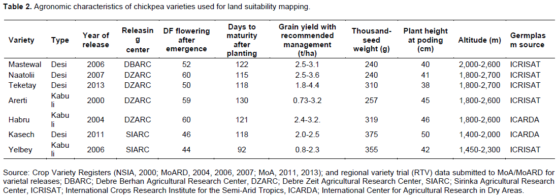
In suitability analysis, seven chickpea varieties (Mastewal, Naatolii, Teketay, Arerti, Habru, Kasech and Yelbe) were used. The varieties were selected based on current production and area coverage in the technology transfer productivity, earliness export, and local market quality parameters (Table 2).
RESULTS AND DISCUSSION
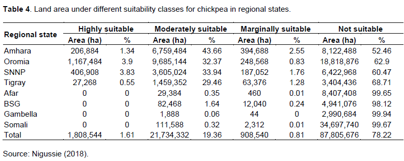
Area and suitability mapping
The chickpea variety level land suitability map adopted from (Nigussie, 2018) that showed the percentage area coverage for each regional state computed based on their respective total area (Table 3).
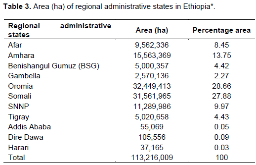
Note: *The total area includes all agriculture, forest, water, town, and other lands bounded within the boundary of each regional state; Addis Abeba, Dire Dawa, and Harari are city administrations with limited agricultural land for crop production.
Crop-level land suitability mapping
From the outset, it should be noted that the suitability analysis in this study does not exclude the areas occupied by non-agricultural areas such as forests, woodlands, towns (except Addis Abeba, Dire Dawa and Harari), and other non-cropland use. It also does not account the updated cropland currently under active cultivation.
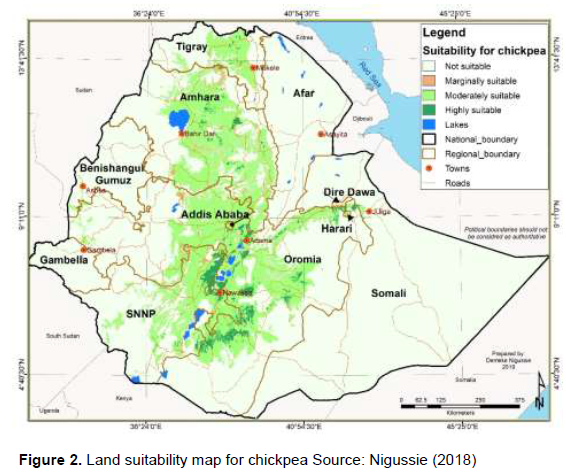
The chickpea's crop level area showed 1.61% (highly suitable) and 19.36% (moderately suitable) for chickpea production across the regions (Figure 2 and Table 4. Generally, chickpea's crop level highly suitable land areas are still larger than the highly suitable land area for most individual varieties. This is expected because the environmental range boundaries for the different suitability class thresholds are defined considering broader ranges of adaptation to encompass the adaptation ranges of most of the varieties currently available.
Individual chickpea variety level land suitability
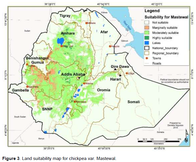
Mastewal (ICCV-92006)
Chickpea variety Mastewal yields, on average, 3.0 and 1.9 tons ha-1 in research and farmers’ fields, respectively (MoARD, 2006). It has a medium seed size (TSW of 240 g) compared to the prior releases of chickpea varieties (Table 2). It is an early maturing variety and can be potentially used in double cropping in areas having a short rainy season (belg) following the harvest of the main rainy season crops. It is preferred for its relatively larger seed size in the local market than the local varieties and its light red color. The variety is relatively tolerant to wilt and root rot fungal diseases.
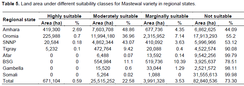
The variety level suitability analysis and mapping results for this variety are shown in Figure 3 and Table 5. When compared with the overall crop level suitability result of chickpea Figure 2 and Table 4, the highly suitable lands for Mastewal are still smaller. The highly suitable lands are in the west-central highlands of Ethiopia, mainly in parts of Amhara and Oromia and SNNPR regional states. The moderately suitable and marginally suitable Mastewal variety areas mainly cover most Amhara and Oromia and central and northern SNNPR.
Naatolii (ICCX-910112-6)
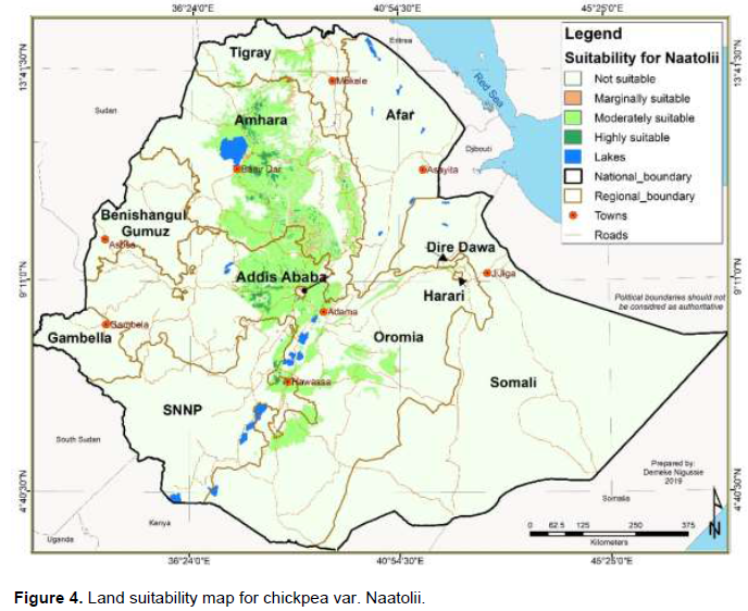
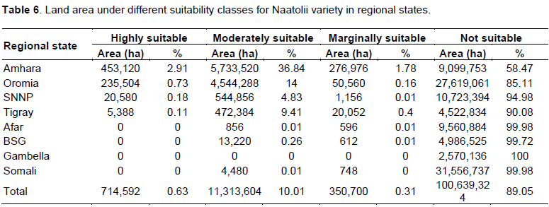
Naatolii grain yields ranged from 2.5-3.5 tons ha-1in the research field (MoARD, 2007). It is a high-yielding and short-duration chickpea variety resistant to fusarium wilt disease in waterlogging Vertisol areas. However, it is recommended to advance the planting date and drain excess water from the field. There are local and foreign market demands to meet producing chickpea varieties like Naatolii, although the supply is very limited, as its production has not yet expanded. It has a local market preference due to its light golden seed color and medium seed size of 240 g of TSW (Table 2). The variety level suitability analysis and mapping results for this variety are shown in Figure 4 and Table 6. The moderately suitable and highly suitable areas for this variety cover large parts of Amhara, followed by central Oromia. It also covers part of central Tigray and northern SNNPR to a smaller extent. Compared with the overall (crop level) suitability result of chickpea, this variety has relatively smaller coverage.
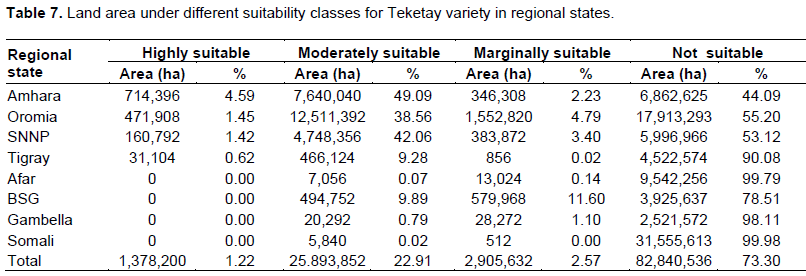
Teketay (ICCX-940002-F5-242P-1-1-1)
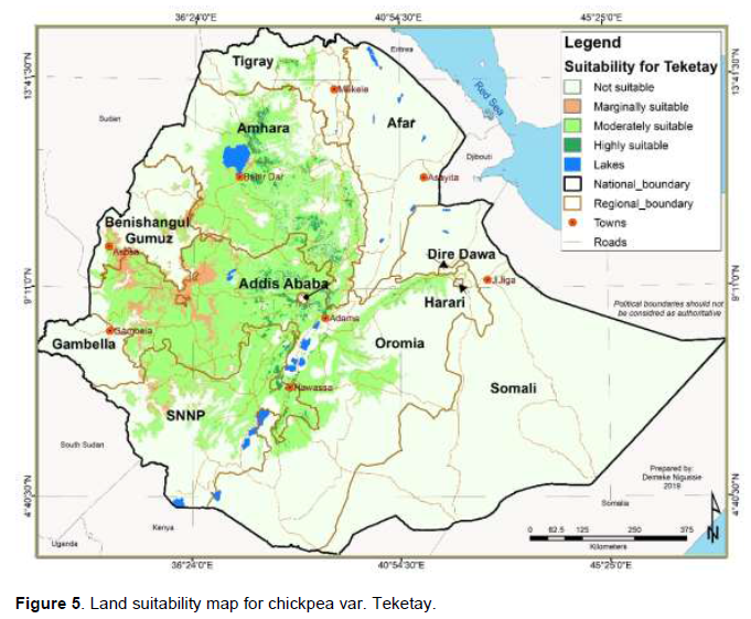
Teketay variety yields, on average, 2.0 to 2.7 and 1.6 to 2.2 tons ha-1 at research stations and on farmers’ fields, respectively, with a medium seed size for having TSW of 310 g (Table 2). The observed yield potential on farmers’ fields during the 2015-2018 scaling project of ICARDA in potential chickpea growing areas of the country was far higher than the yield reported for release, which was attributed to sub-optimal crop management and weather conditions in the selected test locations during nationwide testing.
The variety level suitability analysis and mapping results for this variety are shown in Figure 5 and Table 7. The result shows that the moderately and highly suitable areas for this variety cover large parts of east-central Amhara, followed by central Oromia. It also covers a minor part of central Tigray and northern SNNPR. Compared with the overall crop level suitability map of chickpea, it covers a relatively small area of suitable lands.
Arerti (FLIP 89-84C)
Arerti variety yields, on average, 1.6-5.2 and 1.8-4.7 tons ha-1 in research and farmers’ fields, respectively, with 257 g of TSW (Table 2; NSIA 2000), being medium in seed size. It is widely grown in the country and is a dominant chickpea variety under production due to national level pre-scaling up activities by EIAR and its merits before 2015.
The variety level suitability analysis and mapping results for this variety are shown in Figure 6 and Table 8.
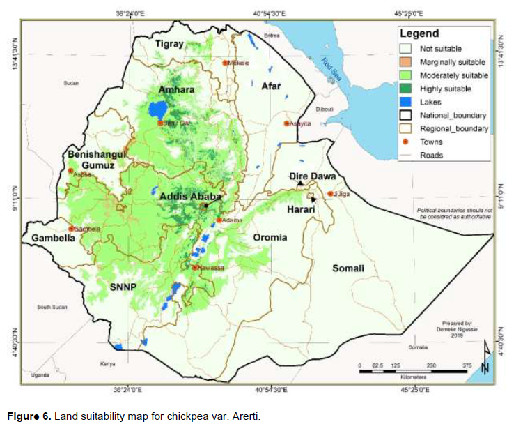
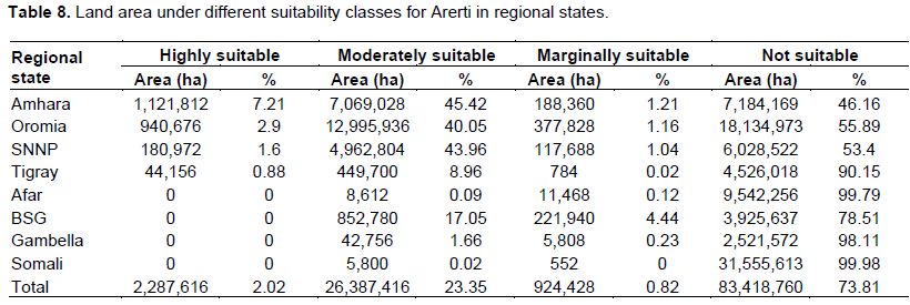
Compared with chickpea's overall crop level suitability result, the highly and moderately suitable areas of Arerti variety are large, covering most of Amhara, Oromia, SNNPR and part of central Tigray. The result shows that the highly suitable areas are larger in the Amhara region when compared with the crop level suitability maps, and they are mainly found in central Amhara and Oromia. Highly suitable lands are larger than the crop level suitability, which is about 1.81 million ha, while that of Arerti variety is 2.29 million ha, the second- largest next to Kasech with 2.4 million ha chickpea varieties included in this study.
Habru (FLIP-88-42C)
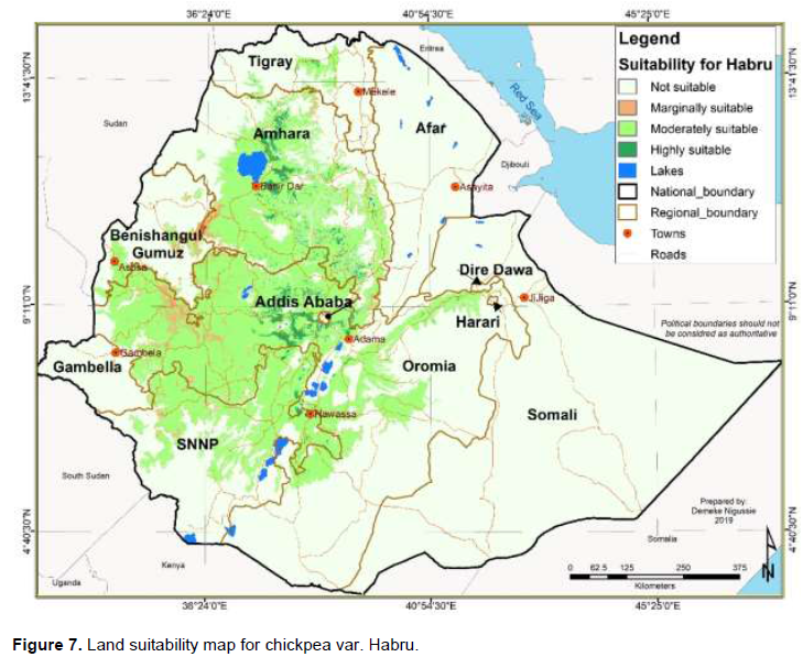
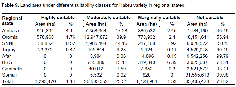
Habru yields, on average, 2.4 to 3.2 tons ha-1 in the research field with TSW of 319 g (Table 2; MoARD, 2004), being medium in seed size, even though it has a relatively larger seed size than chickpea varieties considered, except Yelbey, in this land suitability analysis. It has got wide adaptation and is a dominant variety due to national level pre-scale up activities by EIAR before 2015 in addition to its biological merits, such as better performance in both moisture stress and mid to high altitude areas. This variety is moderately resistant to wilt compared with the overall crop level suitability result of chickpea, shown in Figure 2 and Table 4. Land area under different suitability classes for chickpea in regional states, the suitable areas of Habru variety (Figure 7 and Table 9) is large, covering most of Amhara, Oromia, SNNPR and part of central Tigray. The result shows that the highly suitable areas are larger in Amhara region compared with the chickpea's crop level suitability maps are mainly found in central Amhara and Oromia. Highly suitable areas are still large in the crop-level suitability, which is about 1.8 million ha; while that of Habru variety is 1.29 million ha, which is the third-largest compared with other chickpea varieties.
Kasech (FLIP-95-31C)
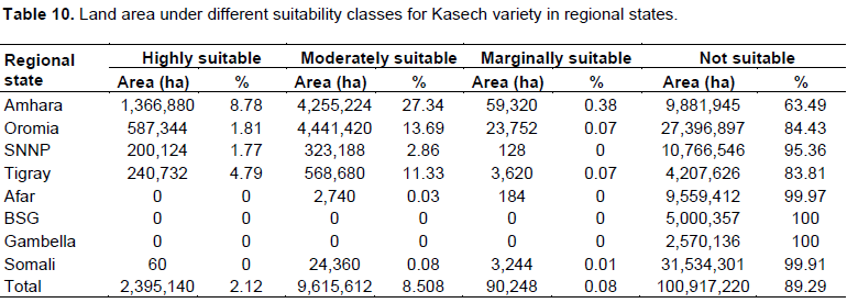
Kasech variety yields, on average, 2.0 to2.5 and 1.6 to2.0 tons ha-1 in research and farmers’ field, respectively, with a TSW of 375g (Table 2; MoA, 2011), which falls in medium seed size although it has the biggest seed size than the varieties included in this study. Even though it is low yielding, Kasech is an early maturing variety, which is well adapted to moisture-stress areas. The variety level suitability analysis and mapping results for this variety are shown in Figure 8 and Table 10. The variety has the largest highly suitable land (2.395 million ha) compared with crop and variety level suitability analysis results. These areas are found in Amhara largely followed by Oromia, Tigray and SNNP However, the combined highly suitable and moderately suitable area of the Kasech variety is still smaller than the crop level suitability and other varieties considered in this analysis.

Yelbey (ICCV-14808)
Yelbey variety yields, on average 1.8 and 1.4 tons ha-1 in research and farmers’ fields, respectively, with a TSW of 355 g (Table 2) (MoARD, 2006). It is medium seed size chickpea, though with the second-largest seed size among the varieties used for land suitability analysis in this study. It is relatively resistant to wilt and root rot. Although its productivity is low, it is early maturing and well adapted to moisture-stress areas.
Compared with the overall crop-level suitability result of chickpea, shown in (Figure 2 and Table 4), the suitable areas of Yelbey variety are smaller than that of the crop level results, mostly covering the central highlands of the country; stretching from most of central Tigray, central and western Amhara, central Oromia, to large parts of northern SNNP (Figure 9 and Table 11).
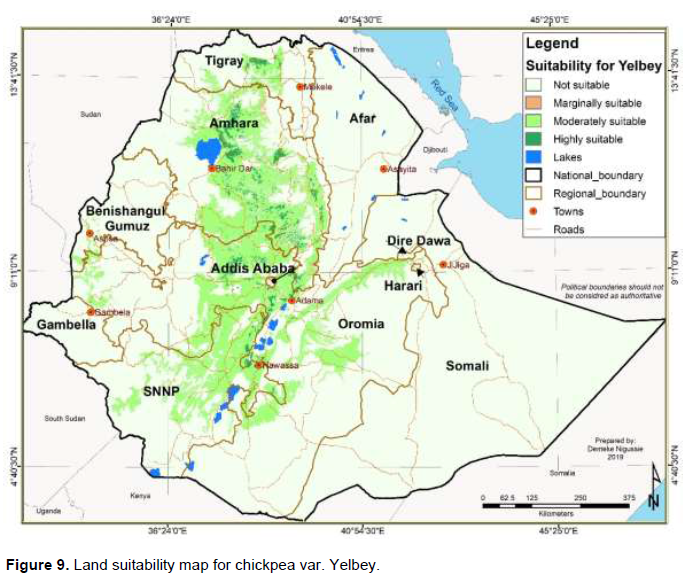
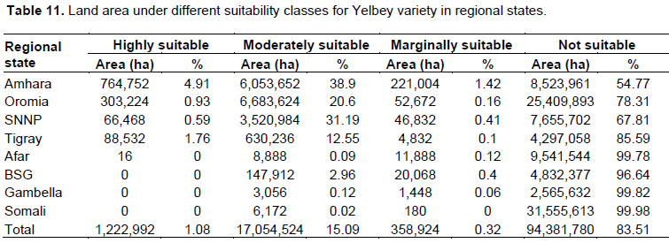
The results show that the highly suitable areas are the fourth largest (1.22 million ha) compared with the variety level suitability results and they are found in Amhara largely followed by Oromia and SNNP.
Toker et al. (2007) indicated drought in chickpea is metrological term and environmental event, defined as water stress due to lack or insufficiency of rainfall and/or inadequate external water supply. Therefore, in our tested chickpea varieties, desi and kabuli types Kasech and Yelbey respectively had short flowering and physiological maturity period among chickpea varieties in the experiment (Table 1). Thus, they can be recommended for moisture stress regions (Afar, Benshangul, Gambella and Somali) based on their earliness for regions with short growing period and low rainfall. In addition, those regions with irrigation potential can curve marginally suitable and not suitable areas to high and moderately suitable areas (Table 4). In general, releasing improved varieties for wide adaptation was not useful in the region/country with diverse environment like Ethiopia rather it should be depending on varieties and the type of biophysical variables experienced in the target environment is essential.
CONCLUSION
1) Amhara, Oromia, SNNP and Tigray remain the major regions with suitable areas for producing available varieties of chickpea compared to Afar, Benishangul Gumuz, Gambella, and Somali regions. However, the highly suitable areas are limited compared to moderately suitable areas, higher across the regions.
2) In general, areas of the highly and moderately suitable lands for most varieties considered in this analysis are smaller than the areas of crop level suitability. This difference is expected since the crop level environmental range boundaries for the suitability class thresholds are defined to encompass the adaptation ranges of available varieties.
3) Chickpea varieties considered in this analysis, the highly suitable areas are much larger than the currently estimated area under chickpea production. For example, some Kabuli chickpea varieties such as Kasech and Arerti have close to 2.3 million ha in highly suitable areas, over estimating crop suitability areas. Overall, Arerti variety, followed by Teketay and Mastewal, has broader adaptation compared to other varieties.
4) Amhara has more highly suitable areas, whereas Oromia has more moderately suitable areas than other regions. Oromia region has more land of moderately suitable area for Arerti and Teketay chickpea varieties with the respective regional share of up to 40.05 and 38.59%.
5) The suitability analysis results show that the currently available improved chickpea varieties can be targeted for scaling out in the identified land suitability classes in Ethiopia with some caution.
ACKNOWLEDGEMENT
This study was funded by ICARDA-USAID project ‘Better livelihoods for smallholder farmers through knowledge-based technology interventions in the highlands of Ethiopia: Increasing the productivity of chickpea in the wheat-based cropping system.
CONFLICT OF INTERESTS
The authors have not declared any conflict of interests.
REFERENCES
|
Agricultural and Agri- Food Canada (AAFC) (2004). Chickpeas: Situation and Outlook, Bi-Weekly Bulletin 19 (13): 1-4. |
|
|
Bekele D, Fikre A, Eshete M, Korbu L, Girma N (2015). Genetic progresses achieved in Ethiopian chickpea (Cicer arietinum L.) breeding program based on grain yield and seed size, 119-134. In: (Korbu, L., T. Damte and A. Fikre (eds.) Harnessing Chickpea Value Chain for Nutrition Security and Commercializing of smallholder Agriculture in Africa.30 January -1 February 2014. Debre Zeit, Ethiopia. |
|
|
Biradar CM, Thenkabail PS, Noojipady P, Yuanjie L, Dheeravath V, Velpuri M, Turral H, Gumma .K, Reddy OGP, Xueliang LC, Xiao X, Schull MA, Alankara RD, S Gunasinghe, Mohideen S (2009). "A global map of rainfed cropland areas (GMRCA) at the end of last millennium using remote sensing." International journal of applied earth observation and geoinformation 11(2):114-129. |
|
|
Central Statistical Agency (CSA) (2015). Key findings of the 2014/2015 Agricultural Sample Surveys, Addis Ababa, Ethiopia: MoFED. |
|
|
Elsheikh F, Abdalla R (2016). Physical Land Suitability Assessment Based on FAO Framework. IOSR Journal of Engineering 12(6):36-44. |
|
|
Food and Agriculture Organization (FAO) (1976). Framework for Land Evaluation. Rome, Italy. |
|
|
Food and Agriculture Organization (FAO) (1984). Land Evaluation: Part Three: Crop Environmental Requirements. Assistance to Land Use Planning. Addis Ababa, Ethiopia: Ministry of Agriculture. |
|
|
Food and Agriculture Organization (FAO) (1993). Guidelines for Land-Use Planning. FAO Development Series 1. FAO, Rome, Italy. |
|
|
Food and Agriculture Organization (FAO) (2007). A framework for land evaluation. FAO soil bulletin no. 6 Rome, Italy. |
|
|
Food and Agriculture Organization (FAO) (2019). FAOSTAT Database. |
|
|
Gaur PM, Gowda CLL, Knights EJ, Warkentin T, Açikgöz, Yadav N SS, Kumar J (2007). Breeding Achievements pp. 391-416. In Chickpea Breeding and management. In: Yadav S.S, Reden R B, Chen W, Sharma B (Eds.), Wallingford, UK: CABI (Centre for Agriculture and Bioscience International). |
|
|
Institute of Biodiversity Conservation (IBC) (2007). Country Report on the State of PGRFA to FAO. Addis Ababa, Ethiopia. |
|
|
International Soil Reference Information Centre (ISRIC) (2015). |
|
|
Jarvis A, Reuter HI, Nelson A, Guevara E (2008). Hole-filled SRTM for the Globe Version 4, |
|
|
Low F, Biradar C, Dubovyk O, Fliemann E, Akramkhanov A, Valleoj NA, Waldner F (2018). Regional-scale monitoring of cropland intensity and productivity with multi-source satellite image time series.GIS Science and Remote Sensing 55(4):539-567. |
|
|
Ministry of Agriculture (MoA) (2013). Crop Variety Register Issue No. 16, Addis Ababa, Ethiopia. |
|
|
Ministry of Agriculture (MoA) (2011). Crop Variety Register Issue No. 14, Addis Ababa, Ethiopia |
|
|
Ministry of Agriculture and Rural Development (MoARD) (2007). Crop Variety Register. Issue No. 10, Addis Ababa, Ethiopia. |
|
|
Ministry of Agriculture and Rural Development (MoARD) (2006). Crop Variety Register. Issue No.9, Addis Ababa, Ethiopia. |
|
|
Ministry of Agriculture and Rural Development (MoARD) (2004). Crop Variety Register. Issue No.7, Addis Ababa, Ethiopia. |
|
|
Mokarram M, Rangzan K, Moezzi A, Baninemeh J (2010). Land suitability evaluation for wheat cultivation by fuzzy theory approach as compared with parametric method. The international archives of the photogrammetry, remote sensing and spatial information sciences - ISPRS Archives 38(2):140-145. |
|
|
Moreno M, Cubero JI (1978). Variation in Cicer arietinum L. Euphytica 27(2):465-485. |
|
|
Nigussie D (2014). Land Suitability Atlas for Selected Crops of Ethiopia. Ethiopian Agricultural Research Institute (EIAR). Addis Ababa, Ethiopia, p.37 |
|
|
Nigussie D (2018). GIS-based land suitability mapping for legume crops technology targeting and scaling-up. Ethiopian Journal of Agricultural Science 6(1):179-198. |
|
|
National Seed Industry Agency, NSIA (2000). Crop Variety Register Issue No.3, Addis Ababa, Ethiopia. |
|
|
Perveen MF, Nagasawa R, Uddin MI, Delowar HKM (2007). Crop-land suitability analysis using a multi-criteria evaluation and GIS approach. University of California, Berkeley, USA: ISDE (International Symposium on Digital Earth). (ISDE5), June (Vol. 5, No. 9). |
|
|
Saaty TL (2008). Decision making with the analytic hierarchy process. International Journal of Services Sciences 1(1):83-98. |
|
|
Singha C, Swai KC (2016). Land suitability evaluation criteria for agricultural crop selection: A review. Agricultural Reviews 37(2):125-132. |
|
|
Toker C, Lluch C, Tejera NA, Serraj R, Siddique KHM (2007). Abiotic stresses 474 - 496. In Chickpea breeding and management (Yadav, S.S., R. B. Reden, W. Chen and B. Sharma (eds.). Wallingford, UK: CABI (Centre for Agriculture and Bioscience International). |
|
|
van der Maesen LJG (1973). Cicer L. a monograph of the genus with special reference to the chickpea (Cicer arietinum L.), its ecology and cultivation. Communication Agriculture University; Wageningen, The Netherlands 72(10):342. |
|
|
Woody Biomass Inventory and Strategic Planning Project (WBISPP) (2004). Woody Biomass Inventory and Strategic Planning Project database. Ministry of Agriculture Addis Ababa, Ethiopia. |
|
Copyright © 2024 Author(s) retain the copyright of this article.
This article is published under the terms of the Creative Commons Attribution License 4.0


