ABSTRACT
Further objectives were to determine the different patterns of land use and occupation within the microbasin formed by these rivers, and to assess the influence of the quantity of riparian vegetation on the presser/vation of the aquatic ecosystems. The studied basin extends over a total area of 77.75 km2, of which 92.98% comprised agriculture (44.11%) and native forest (48.87%). The drainage area of the sampling site P1 was 87.57% covered by crops, and so was 22.30% of the area of the sampling site P4. However, the application of the Tukey test (p < 0.05) to the data for thermotolerant coliforms (also known as faecal coliforms - FC) led to the inference of similarity (p<0.05) between the sampling sites P1 and P4. This indicates that the agriculture impact is probably mitigated by the area of native forest around the source of the spring that feeds P1. From the sampling site P2 to P3, the drainage area showed an improvement in the preservation of natural areas, with the area covered by crops decreasing to 44.41% and an increase of 47.93% in the land covered by native forest. Sampling sites P2 and P3 also showed significant similarity between their annual averages for FC, displaying a reduction in the concentration of these microorganisms from 2.15 to 1.61 (× 10³ MPN/100 mL), which again provided evidence of the positive influence of the recovery of plant cover within the drainage area. Recognising that the other sampling sites with very similar land use characteristics did not display significant alterations in the water quality, the influence of the vegetation and its role as a buffer were made evident, since for these sampling sites most water sources are not bereft of surrounding vegetation. In this way, the lack of correlation (Pearson and Spearman) between the seasonal variations for the assessed water quality parameters allowed us to provide evidence for the positive effect of riparian vegetation in the maintenance of the integrity of aquatic ecosystems and the preservation of the water quality. The water quality comprises physical, chemical, and microbiological parameters related to the different land uses within the river basin.
Key words: Monitoring, total and thermotolerant coliforms, biological indicators, human impact, water quality, multifactorial analysis.
Hydrographic basins where farming takes place have higher concentrations of sediments and nutrients in their flowing waters in comparison to hydrographic basins protected by native vegetation (Allan, 2004). Over time, the various impacts of agriculture and grazing cause a continuous decrease in plant cover around aquatic environments. In addition, the use of land for farming and pastures reduce surface roughness, infiltration, and evapotranspiration (Hoffman and Ries, 1999), which in turn decrease plant root lengths rendering the surface more susceptible to erosion (Beeson and Doyle, 1995).
The integrity of riparian forests lessens the removal of adjacent soil, the loss of aquatic habitats, and the decline of biological diversity by mitigating the effects of surface runoff (Berkman and Rabeni, 1987). When these functions are jeopardised by alterations in the composition of the riparian zone, this zone becomes unstable and may no longer be able to ameliorate changes in physical, chemical (Monaghan and Smith, 2012), and biological (coliforms) parameters of the water resources, which result from surface runoff caused by rainfall (Hong et al., 2010).
Under Article 2 of the Brazilian Forestry Code (Law nº 4.771/65), riparian forests are categorised as Areas for Permanent Preservation (APP) (BRASIL, 1965). Improving the quality of the water in rivers is seen as a priority linked to the width of riparian forests, which is in turn related to the width of watercourses (BRASIL, 1965). In the case of small water basins, the extent and condition of the riparian vegetation can be used as hydrological indicators of the sustainability of human activities that are associated with different land uses (Lima and Zákia, 1998).
One means to assess the human interference through land use is monitoring local water resources (Coradi et al., 2009). The Brazilian National Environment Council (Conselho Nacional do Meio Ambiente, CONAMA), through resolution # 357/05, has established a set of parameters for the monitoring of water quality, corresponding to a number of physical, chemical and biological (total and thermotolerant coliforms) parameters (BRASIL, 2008).
The relations between riparian vegetation, land use, and water quality are not spatially stationary, but depend upon the individual characteristics of each hydrographic basin, for the physical features of the environment, economic activities, and pollution sources will not be constant in space (Tu, 2013).
Since around the analysed rivers the riparian forests are intact, our expectations were the following: (1) No significant variations between the seasons in the concentrations of total coliforms (TC) and thermotolerant coliforms (FC); (2) The type of land use in surrounding areas does not affect water quality in time, and (3) The existence of a direct relationship between the preservation of the riparian vegetation and water quality of the corresponding aquatic environments, regardless of the type of land use. Based upon this perspective, the present study had the following objectives: to determine the different types of land use and occupation for a neotropical river microbasin, to assess the pattern of variations in space and time for the water quality parameters of the rivers of such a basin, and to analyse the influence of riparian vegetation on the integrity of the aquatic ecosystems as a function of land use.
Study area and sampling sites (collection points)
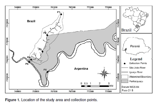
The present study was conducted on the São João River (SJ) and the Iguaçu River (IG), which belong to the hydrographic basin of the Iguaçu River, in the state of Paraná, Brazil. The source of the São João River is located in a rural area, and it drains into the right margin of the Iguaçu River. The Iguaçu River has its source within the city of Curitiba, the capital of the state of Paraná, and discharges into the west of the state, passing through the Iguaçu National Park, before reaching the Paraná River at Foz do Iguaçu.
The courses of both rivers are partially within the Federal Reserve (Unidade de Conservação Federal) known as Iguaçu National Park (ParNaIguaçu - 25° 05’ to 25° 41’ S and 53° 40’ to 54° 38’ W), and with regard to structure are considered typical aquatic ecosystems within this biome (IBAMA, 1999). The sampling sites were labelled P1 to P6; their locations were selected to reflect different land uses and interaction with the reserve. Sampling sites (collection points) P1 to P4 were along São João River, whereas P5 and P6 were located on the Iguaçu River (Figure 1).
Land use determination
A map of land use and occupation was constructed by visual classification of panchromatic images acquired from the updated database available by the Company Environmental Systems Research Institute (ESRI), making use of a geographic information system (GIS), as implemented in the software ArcGIS 10 (ESRI, 2010). Five classes of land use and occupation were defined: Native forest, pasture and reservoirs, agriculture, residential area, and areas of afforestation by exotic species.
Parameters monitored and analytical methods
A total of 72 water samples were assessed each month, from July 2011 to June 2012, by determination of a set of 22 variables in triplicate. Thermotolerant coliforms (FC) and total coliforms (TC) were determined by the Most Probable Number (MPN) technique as described in the manual of Standard Methods (APHA, 2005) and compared against the parameters specified by order # 2914 issued by the Ministry of Health (BRASIL, 2011a) and CONAMA resolution # 357/05 (BRASIL, 2008). Physical and chemical analyses of the water to yield the following: pH, temperature (T), turbidity (TUR), salinity (Sa), electrical conductivity (EC), dissolved oxygen (DO), total dissolved solids (TDS), and flow (Q) were performed in loco with a multiparameter instrument (Horiba® model CEL U50).
Biochemical oxygen demand (BOD - 5 days at 20°C), nitrate (NO3-), nitrite (NO2-), ammonia (NH3), ammonium (NH4+), total nitrogen (TN), phosphate (PO43-), orthophosphate (PO43-)2, and total phosphorus (TP) were quantified according to the manual of Standard Methods (APHA, 2005) in the laboratories of the Iguaçu National Park (AquaIguaçu). Daily, weekly, and monthly rainfall, together with the volumetric flow rates of the Iguaçu and São João Rivers, were provided by the Instituto das Águas do Paraná (ÁGUAS PARANÁ, 2012).
Statistical analyses of the data
Analysis of variance was used for the main effects (One-way ANOVA), followed by comparison of means using the Tukey test (p < 0.05) so that the results could be compared against parameters set by legislation and to identify significant differences between the variables. The scores along the first three axes from the principal component analysis (PCA) were submitted to Two-way ANOVA (Main effects) using month and sampling sites as independent variables.
A multivariate approach was used to identify associations between the physical and chemical parameters: Principal Components Analysis (PCA), in which the determination as to the principal components to retain for data interpretation was set by the Kaiser-Gutman criterion (Jackson, 1993). The data were transformed to log10(x+1) so that the frequency distributions approximated the normality condition.
In the assessment of the effects of rainfall (daily, weekly, and monthly) on the physical, chemical, and biological parameters, the scores along the retained axes were correlated to their abundances through Pearson and Spearman correlation tests. For both tests, correlations with p < 0.05 were considered significant.
For the purposes of determining the degree of similarity between sampling sites as revealed by biotic and abiotic parameters, a clustering analysis (CLUSTER) was performed using the Euclidian distances and UPGMA (Unweighted Pair Group Method with Arithmetic Average) as the joining method (McCune and Grace, 2002). The assessment of the similarities between the collection points was assessed using the ANOSIM (analysis not Parametric Similarity), assuming 9999 permutations and a 0.05 significance level.
The analyses were performed using the software packages PC-ORD 4.0® (McCune and Mefford, 1999), Statistica 7.0® (Statsoft, 2005), Sisvar® (Ferreira, 2007) and Bioestat® (Ayres et al., 2007).
Land use and occupation
The values and the percentages of the classes that differentiate the main forms of land use and occupation within the São João River Microbasin, together with values for the areas of the basin that drain to each sampling site, are presented in Table 1.
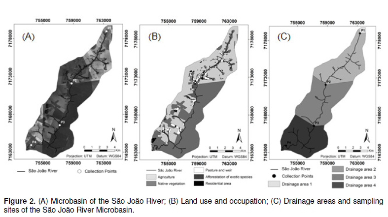
The São João River basin is within the Iguaçu River Basin. The data characterising the land use for the areas that drain to sampling sites P5 and P6 (Iguaçu River) are not presented in Table 1, because these areas lie completely within the Iguaçu National Park, where the only permitted land use is native vegetation. The total area of the São João River Basin is approximately 77.75 km2 (Figure 2a); 92.98% of this area belongs to the classes of agriculture (44.11%) and native forest (48.87%). The area of the São João River Basin whose quality was monitored through P1 (springs located inside a private reserve, Reserva Particular de Patrimônio Natural de Santa Maria) was influenced primarily by agriculture (87.57%), and to a lesser extent by native forest (12.42%) found within a radius of approximately 50 m around the source of the São João River.
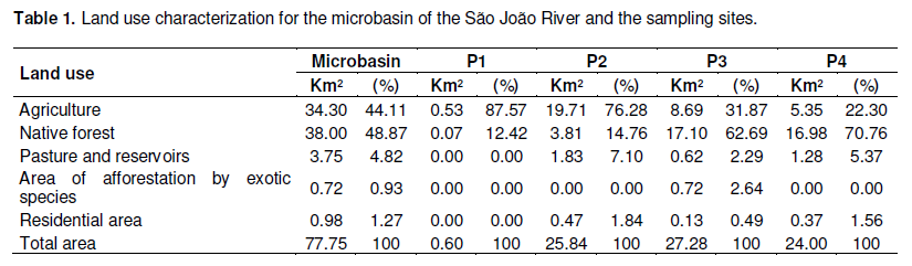
For sampling site P2, the most prevalent class of land use was agriculture (76.28%); native forest represented just 14.76% for this drainage area, followed by pasture and reservoirs, and residential areas.
Although the percentage of native vegetation around sampling siteP1 was low, it is within the limits established by Article 2 of the Brazilian Forestry Code (Law nº4.771/65) (BRASIL, 1965). The main watercourse feeding sampling site P2 also complied with the minimum limits of the same legislation for plant cover. However, the 11 springs that drain to sampling site P2 are bereft of vegetation on their margins, and display high levels of human activities in their surroundings (Figure 2b); both are factors which invariably influence water quality of the tributaries and consequently the main riverbed.
Stands of exotic tree species (Eucalyptus globulus Labill.) are found only within the area draining to sampling site P3, though the major class of land use for this area is native forest (62.69%), with a contribution of 31.87% from agriculture. Four streams run through the drainage area of sampling site P3 to the main riverbed of the São João River, two of these rise and flow through the interior of the Iguaçu National Park until their point of discharge. In contrast, the margins of the third and fourth streams are not protected by a riparian zone, and suffer the effects of heterogeneity of land use and occupation (Figures 2b and c).
Similarly for sampling site P4, two streams that lack riparian zones drain to the main riverbed the alterations caused by agriculture (22.30%), pasture (5.37%), and residential areas (1.56%), in contrast to the 70.76% of native forest, which influences the water quality of the third stream (Figures 2B and C).
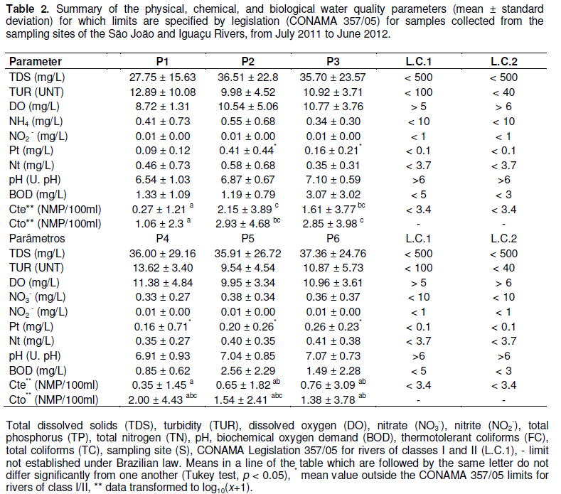
Water quality parameters and seasonal variations: Annual means for the physical and chemical parameters for which limits are specified by legislation CONAMA 357/05 (BRASIL, 2008) for rivers of water quality classes I and II are presented in Table 2 for each of the sampling sites. This table also contains the values of thermotolerant coliforms (FC) and total coliforms (TC) and the Tukey test results (p < 0.05).
The means for the physical and chemical parameters of the water were compared against the standards established by CONAMA Resolution 357/05 (BRASIL, 2008) and the limits for freshwater of class I (São João River) and class II (Iguaçu River). For sampling sites P2 to P6 the only parameter above the limit specified by the legislation was total phosphorus (upper limit 0.1 mg/L); parameters were within the limits specified (Table 2).
This could be expected, for the São João and Iguaçu Rivers flow through farming and urban areas, respectively, and it is well known that the use of land for agriculture or as pasture within river basins promotes a gradual increase in the concentration of phosphorus in the water (Dodds and Oakes, 2006). Furthermore, the input of allochthonous phosphate-containing materials in these areas is evidence of human actions directly interfering with water quality (Andrade et al., 2007).
Despite the inversion of the proportions of land use assigned to the native forest and agriculture classes between P1 and P4 (Table 1), the significance test applied to the water quality bioindicator FC led to the inference of similarity between the sampling sites (Table 2). This is probably due to mitigation of farming-related impacts by the area of native forest that surrounds the spring feeding P1 (Reserva Particular de Patrimônio Natural de Santa Maria), which is sufficient for the preservation of the stream according to the range determined by current Brazilian legislation (BRASIL, 1965).
From P2 to P3, the drainage area showed an improve-ment in the preservation of the natural vegetation, with the area given over to farming decreasing by 44.41% and an increase of 47.93% in the area covered by native forest (Table 1). However, sampling sites P2 and P3 showed the highest annual mean values for FC (Table 2). Among the most common sources of microbial contamination (TC and FC) are livestock breeding, areas of pasture, confinement, and application of compost for agricultural purposes, for which evidence was found in the drainage areas of P2 and P3 (Figure 2B) (Gazzaz et al., 2012). Despite the closeness of these sampling sites to common sources of pollution and the lack of a significant difference in the values for thermotolerant coliforms (FC), there was a reduction in the volume of thermotolerant coliforms from 2.15 to 1.61 MPN/100 ml, for the P2 and P3 respectively. This could also indicate the positive influence of recovery of the local vegetation in the drainage areas close to these sampling sites.
Sampling sites P5 and P6 did not show a significant difference in their thermotolerant coliforms concentrations, further there was significant similarity with the most preserved sampling sites (P1 and P4) (Table 2). These results indicate that the continuous flow of the river remains this parameter stable, even with the intense human activity from visits to the Iguaçu Falls, which attracted approximately 1,4 million visitors between the sampling sites in question (P5 and P6) (ICMBio, 2013).
The correlation analyses (Pearson and Spearman) revealed a lack of linear association between the physical, chemical, and biological parameters and the daily, weekly, and monthly rainfall. Further, the multivariate analysis (PCA) did not reveal temporal clustering (seasonality) of the physical and chemical parameters.
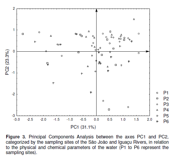
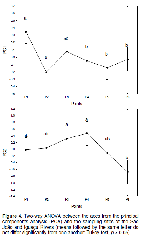
The assessment of the associations between the environmental parameters provided evidence for the individual participation of the physical and chemical variables on the quality of the water. The first two axes obtained from the principal components analysis (PCA) were able to explain 54.5% of the environmental variation related to physical and chemical variables of the water from sampling sites (Figure 3).
The variables which negatively influenced axis 1 (PC1) were nitrate, nitrite, and orthophosphate. The second axis (PC2) selected the variables that contributed negatively to its formation, which were ammonia and the ammonium ion. The groupings formed by sampling sites P1 and P3 (related to axis PC1), and P3 and P4 (related to PC2) may be labelled as the ‘group of dissolved solids’ (Figure 4). These free nutrients play an important role in the ecological processes of the trophic chain of aquatic ecosystems and its distribution in the water column (Guedes et al., 2012). The sampling sites (P1, P3 and P4) most influenced by the group of dissolved solids are those with the greatest integrity of riparian forest, which through being in partial or total contact with the reserve were consequently less influenced by different forms of land use.
The occurrence in the water column of nitrogen-containing compounds that influenced the axes in this research may be directly linked to the processes of production and decomposition of organic matter (Esteves and Amado, 2011). It is evident that the input of phosphate-containing nutrients found on the axes could vary according to the different climatic conditions and vegetation of the drainage basin, for they are mainly generated through the deposition of particulate material, living organisms, and organic matter derived from leaf decomposition within the riparian zone (Esteves and Panosso, 2011).
Furthermore, the main source of energy and nutrients in continental aquatic ecosystems is basically formed from leaf detritus coming from the riparian zone. These allochthonous inputs are fundamental to the under-standing of the energy flow and for the maintenance of the metabolism of lotic aquatic ecosystems, especially in Neotropical regions (Esteves and Junior, 2011).
The cluster grouping analysis revealed that the sampling sites could be divided into two large groups: ‘G1’, corresponding to the São João River and ‘G2’ corresponding to Iguaçu River. Within these groupings, three distinct groups (A, B and C) were formed, between which there was greater heterogeneity (Figure 5).
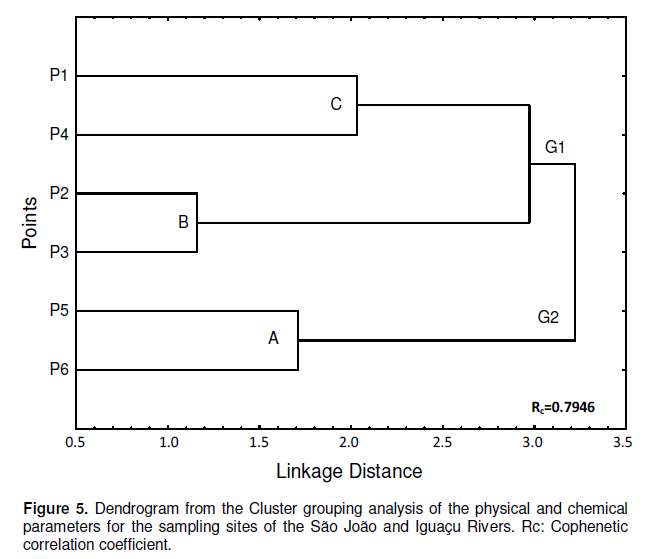
The first grouping (B) was composed of P2 and P3, both highly affected by human activities. Sampling site P1 and P4 (C), close to the boundary of the Iguaçu National Park, and appeared separately from the others, probably as a result of the self-purification processes occurring along the length of the São João River and action protection of riparian vegetation formed by the RPPNSM (P1) and ParNaIguaçu (P4).
Sampling site P1 and P4 (grouping C) stood out from the others, which constitute the São João River region in contact with the protected forest, and when compared to the other sampling sites, it displayed unique physical, chemical, and biological characteristics. The large group 2 was composed of sampling sites P5 and P6 (grouping A), both these sites are located on the Iguaçu River within the Iguaçu National Park, and displayed similar environmental characteristics.
Based upon the similarity evidenced through the cluster analysis confirmed by Analysis Not Parametric similarity to p <0.05 for P1-P4 points, P2-P3 and P5 and P6 and cophenetic correlation coefficient (Rc = 0.7946), it was possible to establish that the analyses of water from sampling sites P1, P2 and P6 would have been sufficient for the purposes of assessing the water quality from these locations. Thus, it will be possible to optimize the sampling in future monitoring campaigns, reducing the cost and labour without decreasing the reliability of the data.
The São João River Microbasin is composed of five different classes of land use: Native forest, pasture and reservoirs, agriculture, residential areas, and areas of afforestation by exotic species. Although native forest and agriculture were the predominant land use classes in this microbasin, this was not found to be true for the drainage areas of the sampling sites. The physical, chemical, and biological variables of water quality did not show correlations with rainfall patterns (seasonality). However, there were relations between the quality of the water resources and the location of the sampling sites. The values of the physical and chemical variables of the assessed sampling sites were within the limits required by the current Brazilian legislation, when they were not influenced by water coming from streams bereft of riparian vegetation. The influence of these streams can also be seen through a direct proportionality, with the significant increase in the biological indicators. It was established that the integrity of the aquatic ecosystems suffered no significant interference form the different types of land use, provided that the riparian zone remained well preserved. However, evidence was found for local alterations in the integrity of the aquatic ecosystems and in the quality of the water for the sampling sites fed by streams lacking the protection from riparian forests.
The authors have not declared any conflict of interest.
The authors are thankful to: CAPES (government agency linked to the Brazilian Ministry of Education in charge of promoting high standards for post-graduate courses in Brazil) and CNPq (National Council for Scientific and Technological Development) for funding of the research; Itaipú Technological Park for the scholarship.
REFERENCES
|
Águas paraná, Instituto das Águas do Paraná (2012).
|
|
|
|
Allan JD (2004). Landscapes and riverscapes: The influence of land use on stream ecosystems. Ann. Rev. Ecol. Evol. 35:257-284.
Crossref
|
|
|
|
|
Andrade EM, Araujo LFP, Rosa MF, Disney W, Alves AB (2007). Seleção dos indicadores de qualidade da água das águas superficiais pelo emprego de análise multivariada. Eng. Agríc. 27:683-690.
Crossref
|
|
|
|
|
APHA (American Public Health Association) (2005). Standard Method for the Examination of Water and Wastewater. APHA, AWWA, WEF, Washington, D.C., 1193 p.
|
|
|
|
|
Ayres M, Ayres Junior M, Ayres DL, Santos AAS (2007). Software BioEstat 5.0: aplicações estatísticas nas áreas das Ciências Biomédicas. Sociedade Civil Mamirauá: Belém, Pará-Brasil. Aplicações estatísticas nas áreas das ciências biomédicas. Ong Mamiraua. Belém (PA) 324p.
|
|
|
|
|
Beeson CE, Doyle PF (1995). Comparison of bank erosion at vegetated and non-vegetated channel bends. Water Res. 31:983-990.
Crossref
|
|
|
|
|
Berkman HE, Rabeni CF (1987). Effect of siltation on stream fish communities. Environ. Biol. Fish. 18:285-294.
Crossref
|
|
|
|
|
BRASIL (1965). Código Florestal Brasileiro/Lei federal nº 4.771/65 de 15 de setembro de 1965.
|
|
|
|
|
BRASIL, Ministério do Meio Ambiente (2008). Conselho Nacional do Meio Ambiente. Resolução nº 357, de 17 de março de 2005. Dispõe sobre a classificação dos corpos de água e diretrizes ambientais para o seu enquadramento bem como estabelece condições e padrões de lançamento de efluentes e dá outras providências. In: Resoluções do CONAMA: resoluções vigentes publicadas entre julho de 1984 e novembro de 2008. CONAMA, Brasília, pp. 280-357.
|
|
|
|
|
BRASIL (2011a). Ministério da Saúde/Portaria nº 2914/MS de 11 de dezembro de 2011. Diário Oficial da República Federativa do Brasil, Brasília.
|
|
|
|
|
Coradi PC, Fia R, Pereira-Ramirez O (2009). Avaliação da qualidade da água. Ambi-Agua. 4:46-56.
Crossref
|
|
|
|
|
Dodds WK, Oakes RM (2006). Controls on nutrients across a prairie stream watershed: Land use and riparian cover effects. Environ. Manage. 37:634-646.
Crossref
|
|
|
|
|
ESRI, Software (2010).
|
|
|
|
|
Esteves FA, Amado AM (2011). Nitrogênio. In: Esteves, F.A. (Eds). Fundamentos de limnologia. Rio de Janeiro: Interciência. 13:239-258.
|
|
|
|
|
Esteves FA, Junior JFG (2011). Etapas do metabolismo aquático. In: Esteves, F.A. (Eds). Fundamentos de limnologia. Rio de Janeiro: Interciência. 7:119-124.
|
|
|
|
|
Esteves FA, Panosso R (2011). Fósforo. In: Esteves, F.A. (Eds). Fundamentos de limnologia. Rio de Janeiro: Interciência. 14:259-282.
|
|
|
|
|
Ferreira DF (2007). Sistema Sisvar para análises estatísticas.
|
|
|
|
|
Gazzaz NM, Yusoff MK, Ramli MF, Aris AZ, Juahir H (2012). Characterization of spatial patterns in river water quality using chemometric pattern recognition techniques. Mar. Pollut. Bull. 64:688-698.
Crossref
|
|
|
|
|
Guedes HAS, Silva DD, Elesbon AAA, Ribeiro CBM, Matos AT, Soares JHP (2012). Aplicação da análise estatística multivariada no estudo da qualidade da água do Rio Pomba, MG. Rev. Bras. Eng. Agríc. Ambient. 16:588-563.
|
|
|
|
|
Hoffman L, Ries RE (1999). Relationship of soil and plant characteristics to erosion and runoff on pasture and range. J. Soil Water Conserv. 46:143-147.
|
|
|
|
|
Hong H, Quiu J, Liang Y (2010). Environmental factors influencing the distribution of total and fecal coliform bacteria in six water storage reservoirs in the Pearl River Delta Region, China. J. Environ. Sci. 22:663-668.
Crossref
|
|
|
|
|
IBAMA, Instituto Brasileiro do Meio Ambiente - Brasil (1999). In: Plano de Manejo do Parque Nacional do Iguaçu: Encarte 6.
|
|
|
|
|
ICMBio. Instituto Chico Mendes de Conservação da Biodiversidade-Brasil (2013). Available at
View
|
|
|
Jackson DA (1993). Stopping rules in principal components analysis: a comparison of heuristical and statistical approaches. Ecology 74:2204-2214.
Crossref
|
|
|
|
|
Lima WP, Zákia MJB (1998). Indicadores hidrológicos em áreas florestais. Série Técnica IPEF. 12:53-64.
|
|
|
|
|
McCune B, Grace JB (2002). Analysis of Ecological Communities. MjM Software, Gleneden Beach, Oregon. 125p.
|
|
|
|
|
McCune B, Mefford MJ (1999). PC-ORD. Multivariate Analysis of Ecological Data, Version 4. MjM Software Design, Gleneden Beach, OR, USA. 237p.
|
|
|
|
|
Monaghan RM, Smith LC (2012). Contaminant losses in overland flow from dairy farm laneways in southern New Zealand. Agric. Ecosyst. Environ. 159:170-175.
Crossref
|
|
|
|
|
Statsoft, Statistica (data analysis software system) version 7.1. (2005). Available at
View
|
|
|
|
|
Tu J (2013). Spatial variations in the relationships between land use and water quality across an urbanization gradient in the watersheds of northern Georgia, USA. Environ. Manage. 51:1-17.
Crossref
|
|