ABSTRACT
In Ethiopia, deforestation is a major challenge which leads to increased human encroachment upon wild areas and threats to biodiversity. In line with this, the aim of the current study was to assess woody species diversity and threats in Hotessa forest. Systematic sampling method was used to collect vegetation data. Accordingly, 100 plots each with 400 m2 (20 m × 20 m) for woody species was laid along transect line. In each of these plots, all woody species were collected. Simple random sampling was used to identify target population and in-depth interviews were conducted with farmers living in close vicinity to the forest to identify challenges and threats on the forest. A total of 43 woody species distributed to 37 genera and 28 families were identified and documented. Fabaceae is the dominant families in terms of species richness. The Shannon-Wiener diversity index computed for the three different altitudinal gradients and showed that lower altitude is the most diverse and has more or less even distribution of species. In general, the diversity and evenness of woody species in the forest was 2.575 and 0.98 respectively. The result of analysis of the responses to human-induced factors responsible for deforestation in the study revealed that most of the respondents attributed population growth (80.82%) as the major factor responsible for deforestation in the study area.
Key words: Diversity index, Shannon-Wiener, farmers, interview, sampling.
Different scholars in their study reported that in our world, the total global forest area has declined by 3%, from 4128 million ha in 1990 to 3999 million ha in 2015 (Keenan et al., 2015). Previous study by Reynolds et al. (2007) state that, the decline of vegetation cover is one of the most serious challenges facing humankind today. Same applies to country Ethiopia which also facing severe land degradation (Solomon, 2015). According to FAO (2016) land-use change is not necessarily the same as land-cover change. Land cover is the observed biophysical cover of the earth’s surface, but land use reflects the actions of people and their intentions and the former is far more widespread than the latter, with deforestation occurring when people clear forests and use the land for other purposes, such as agriculture, infrastructure, human settlements and mining (FAO, 2016). Daniel (2016) in his study reported that land cover is constantly changing with different patterns and magnitudes in sub-Saharan Africa and the Sahel in particular. Currently in Ethiopia, the natural vegetation is highly affected by several factors such as, agricultural expansion, settlement, deforestation, land degradation, and increment in invasive species occurrence and logging practice which seriously damages the structure and composition of natural woody plant species and leading to the declining of forest biodiversity and agricultural yield in Ethiopia (Mohammed, 2011; Khumalo et al., 2012; Ariti et al., 2015; Gashaw and Dinkayoh, 2015; Bessie et al., 2016;
Negasi et al., 2018) and with the present annual rate of deforestation 2% it continues (Moges et al., 2010).
Ethiopia is a mountainous country with great geographic diversity like rugged mountains, flat-topped plateaus and deep gorges incised river valleys and rolling plains (Teweldebrhan, 1988). This makes the country one of the largest forest resources in the horn of Africa and it owns a total of 53.1 million ha covered by woody vegetation which consists of 12.5 million ha of forest land and 40.6 million ha of woodland (FAO, 2016). The total forest area of the country has declined from 15.1 million ha in 1990 to 12.5 million ha in 2015. The annual rate of forest land decline is 104, 600 ha per year that is 0.8% of forest cover of the country (FAO, 2016). According to this report in total, Ethiopia lost 18.6% of its forest cover or around 2,818,000 hectare between 1990 and 2010.
Similarly, Stern (2006) the underlying causes of deforestation and degradation based on a framework analysis were identified as population growth, insecure land tenure, and poor law enforcement. The decline of forest capacity at the global and national level is a great problem that currently affects the livelihoods of people in different ways also reported by Asfaw and Fekadu (2018). However, there are evidences that indicate sustainable farming practices, like agroforestry. The same as in Bensa Woreda, there was high rate of agricultural expansion observed, especially in mountainous area which leads to deforestation and high rate of loss of woody species and sparsely diversified trees due to over population, logging and land fragmentations. Study has not been conducted before on floristic diversity and the threats of this area and has necessitated the qualitative and quantitative assessment of vegetation and threats on forest resources of the Woreda. Regarding this, systematic field survey of flora and fauna is a prerequisite for developing effective conservation programs and its implementation Kent and Coker (1992). The resulting information on vegetation is essential to solve ecological problems, for biological conservation and management purposes as indicated by Noriko et al. (2012). Thus, it is important to identify plant species diversity, species composition and drivers of deforestation of Hotessa forest. Additionally, the current study serves as spring border to narrow the gap on those forest management planners to use this information in their decisions on forest conservation and product use.
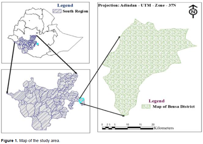
Description of the study area
This study was conducted in Bensa Woreda, Sidama zone in Southern Nations Nationalities and Peoples’ Region (SNNPR) of Ethiopia. Bensa Woreda is one of the 19 districts in Sidama zone that extends into the Oromia region of Bale Zone or Borana-like peninsula. Bensa Woreda is bordered on the south and north by the Oromia Region, with Bona Zuria on the west, Arbegona district on the northwest, Chere district on the east, and Aroresa district on the southeast. Daye, the capital of Bensa Woredat, is located at 420 km southeast of Addis Ababa and 135 km northeast of Hawassa city, the SNNPR capital city. Bensa Woreda is located at altitude which ranges from 1452 to 3129 m above sea level. The two rainy seasons are the belg (short rainy season), which covers from late February to May, and the kremt (main rainy season), which extends from late June to early October. The average annual rainfall of the area is 1208.5 mm. The average annual temperature of the Woreda is 19°C. The Woreda has three major agro ecologies, with 50% were moist weyna dega (mid-altitude), 36% moist dega (highland) and 14% moist kola (lowland) (Bensa woreda pilot Learning Site diagnosis and program design, LIVES, 2012) (Figure 1).
The dominant soil type in the study area is loam soil. During the reconnaissance survey together with Woreda agricultural office expert informal communication, from the total area of the study site about half was covered by dense forest before one or two decades. However at present, the forest cover has diminished and the hazard of soil erosion and land degradation has increased. The cause for diminishing forest cover is increasing agricultural land expansion, fuel wood demand and timber production. As learned from the local elders, indigenous tree species like Olea europea, Hygeia abyssinica, Podocurpus falcatus and Bamboo (arborescent grass) were dominant before two decades. Nonetheless, currently H. abyssinica and P. falcatus has totally disappeared from the forest area. The total population of the study area is estimated to be 342,545 (Bensa Woreda Administration office, 2018).
Sampling design, sampling size determination and data collection
Bensa Woreda was purposively selected based on its floral diversity and unstudied area. A reconnaissance survey was made to obtain an impression on the general physiognomy of the vegetation and to identify sampling sites. Twenty transect lines was systematically laid to ensure that sample sites were cover representatives of major vegetation types occurring in the study area based on altitude gradient: namely, upper altitude (3 transect lines), middle (10 transect lines) and lower (7 transect lines) proportionally to their size. A total of 100 quadrants, Plots size of 20 × 20 m (400m2), were used for collection of floristic data at 100 m distance interval (Muller-Dombosis and Ellenberg, 1974). From each 20 x 20 m plot, a complete list of shrubs (woody plants having several stems 2 m tall and trees (woody plants having a dominant stem and more than 2m tall) was recorded. Plant identification was carried out at the field and confirmed at National Herbarium. Nomenclature followed the published volume of Flora of Ethiopia and Eritrea (Edwards et al., 2000; Hedberg et al., 2006, 2009) and Azene (2007).
Regarding the target population, the sampled population was identified using simple random sampling on the number of house hold leader to analyze the factors currently creating a threat to plant diversity. The questionnaire covered various socio-economic and demographic characteristics of the households, forest livelihood and forest land-use (Appendix 1). Socio-economic factors include age and education of the household head and land holdings (Appendix 1). The structure of the questionnaire was designed to meet the objectives of the study and pre-coded for ease of data collection and analysis. The questionnaire was semi-structured in and allowing for flexibility in responding to the questions (Appendix 1). The questionnaire was administered to all the household heads in selected villages. The criteria for village selection were based on agricultural practices and accessibility to forest. The sample size for the target population was determined using the following sample size determination formula (Kothari, 1985).
Woody species composition of the forest
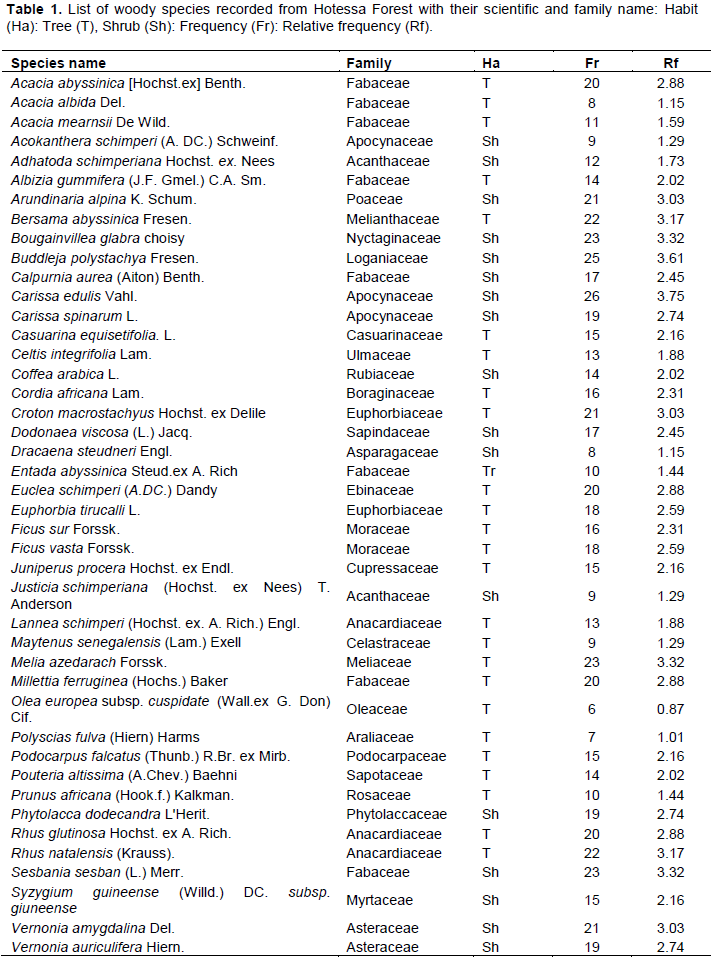
A total of 43 species (26 trees and 17 shrubs) belonging to 28 families and 37 genera were recorded and identified from 100 quadrats examined from the study area (Table 1). Of all the families, Fabaceae, Anacardiaceae and Apocynaceae were the three most dominant families represented by 6, 2 and 2 genera, and 8, 3 and 3 species respectively. These three dominant families together constituted 14 (32.6%) of the total species richness in Hotessa forest. The next dominant families Acanthaceae, Asteraceae, Euphorbiaceae and Moraceae (each represented by 2 species or 18.6% together) and the remaining 21 families were mono specific (Table 1).
The study area is rich in species diversity and home for different plant communities. In this study, top seven families contributed to about 51% of all the 28 plant families recorded in the area. Other scholars studies conducted in woodlands of Ethiopia also reported similar findings. For instance Eba and Lenjisa (2017) identified 18 species; Zerihun et al. (2017) 15 species; Dagne and Tamru (2018) 15 species; Tesfaye et al. (2019) 5 species respectively in their study. In terms of species richness, the dominance of Fabaceae was reported from similar vegetation studies done by different scholars in the country such as Zerihun et al. (2017) and Tesfaye et al. (2019). The dominance of Fabaceae is also in line with the assessment results that show the dominance positions in the Flora of Ethiopia and Eritrea (Zerihun et al. (2017). This might have got the top dominant position probably due to having efficient pollination and successful seed dispersal mechanisms that might have adapted it to a wide range of ecological conditions in the past (Ensermu and Teshome, 2008; as cited by Zerihun et al. 2017). Some plant species like Bougainvillea glabra, Casuarina equisetifolia, Coffee arabica, Melia azedarach, Euphorbia tirucalli and Dracaena steudneri observed both in the forest and on the fence and farm lands of the marginal or adjacent villages of the forest. This might be easy to domesticate and local people used as ornamental plants (Bougainvillea glabra, Coffee arabica and Dracaena steudneri) and as a fence for ther farm land (Euphorbia tirucalli) and Melia azedarach and Casuarina equisetifolia as fodder for their cattle and fuel wood.
Species richness of the study area
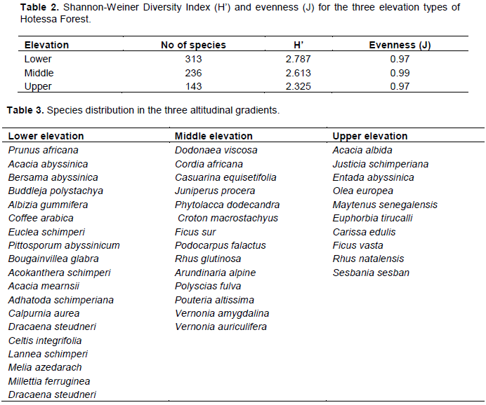
According to Kent and Coker (1992) the Shannon Weiner index is the most frequently used index for the combination of species richness and relative abundance. With respect to this, the Shannon-Wiener diversity index was computed for the three different altitudinal gradients (Table 2). Lower altitude is found to be more diversified in species richness followed by middle and upper altitude. Pielou (1969) also stated that value of the index of Shannon-Weiner usually lies between 1.5 and 3.5; although in exceptional case, the value can exceed 4.5. Thus, the value of Shannon-Wiener Diversity Index of this study area occurs between 2.325 and 2.787. Here the analysis showed that the entire three altitudinal gradients were rich in species diversity. This might have due to the presence of sparsely distributed woody plant species compositions in all parts of the forest. During data collection the researcher observed that the local people still high contact with forest core zone (at middle and upper altitude) than the margin (buffer zone) of the forest. Equitability (evenness) is used to measures the relative abundance of different species. The higher the value of J, the more even the species is in their distribution. Thus, middle altitude has the highest even distribution whereas upper and lower altitude has the least even distribution respectively. In general, the diversity and evenness of woody species in the forest was 2.575 and 0.98 respectively. This is indicating that the diversity and distributions of woody species in the forest were relatively high.
Important value index
Out of the 43 species recorded in the site Carissa edulis accounted, 11.45% of the relative abundance followed by Buddleja polystachya (11.01), B. glabra, Sesbania sesban and M. azedarach (10.13) (Table 3). According to Premavani et al. (2014) important value index values have helped to understand the ecological significance of tree species in community structure. Shamble (2011) also indicated that important value index of woody species were calculated either from relative density or relative dominance or relative frequency. With respect to this, the important value index of woody species of Hotessa forest was calculated. As a result, ten most dominant tree species of Hotessa forest occupied 32.75% of the total important value index (Table 1). Those dominant species were Carissa edulis, Buddleja polystachya, Bougainvillea glabra, M. azedarach, Sesbania sesban, Rhus natalensis, Bersama abyssinica, Arundinaria alpine, Croton macrostachyus and Vernonia amygdalina. These trees were said to be tolerant and well adapted to the ecological interaction and the wider distribution shows their higher socio-economic and environmental role of the specific study site. From those species Bougainvillea glabra and Melia azedarach were found in the lower altitude and common in the forest and adjacent villages; whereas, Sesbania sesban is found in the upper altitude and important ecological role. In terms of abundance and distribution the contribution of Carissa edulis and Buddleja polystachya were the highest of all tree species; while Olea europea subsp. cuspidate had low relative frequency than the other. This might be due to over exploitation of the species for specific uses like timber, construction and firewood in the study area (Table 3). This indicates the species is under threat and needs immediate conservation measures from the concerned bodies. It has been well recognized through this study that different species has sparse distribution. The total density of woody plants was 551 individuals (stems) per hectare. Which means Density= number of individual tree /total sampling area (0.72 ha) and the relative density was 765/ha.


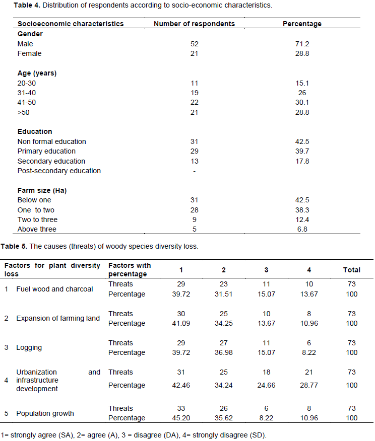
Socioeconomic characteristics of the interviewed respondents
As seen from Table 4, respondents were mostly males (71.2%) and aged between 41 to 50 (30.1%) with most of them having not attended formal education and some attended primary school (42.5 and 39.7%) and possessed at least a hectare of farmland (57.5%). The dominance of the aged and youth population in this survey is an indication that agriculture has been abandoned, which is a challenge to food insecurity and the people are mostly limited to subsistence farming, with most of them adopting outdated and environmentally unfriendly agricultural techniques. This invariably contributes to deforestation and soil degradation. Again, the fact that most of them attained primary school (39.7%) is an indication that they may not be in tune with new farming techniques that lay more emphasis on conservation tillage, contour plowing to control erosion, and adoption of intensive farming rather than extensive farming to control deforestation and prevent loss of valuable species of economic and medicinal values.
Respondent opinion on causes of woody species diversity decrement
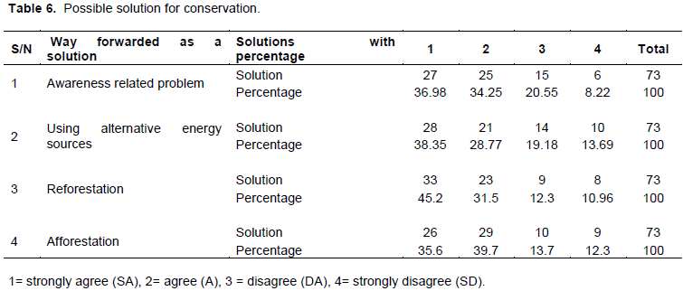
Understanding drivers of deforestation and degradation is fundamental for the development of policies and pre-request measures (Noriko et al., 2012). The result of analysis of the responses to factors responsible for deforestation in the study area is presented (Table 5) and it revealed that most of the respondents attributed population growth (80.82%) as the major factor responsible as a threat for deforestation in the study area. This is in line with Salafsky et al. (2008), who saw it as level 1 threat followed by Urbanization and infrastructure development and identified as level 2 threat (76.7%), logging as level 2 threat (76.7%), expansion of farming land as level 1 threat (75.34%) and fuel wood and charcoal as level 2 threat (71.23%). The implication therefore is that population growth is regarded as the overwhelming cause of deforestation in the study area.
According to Salafsky et al. (2008) threats are defined as the proximate activities or processes that have caused, are causing, or may in the future cause the destruction, degradation, and/or impairment of the entity being assessed (population, species, community, or ecosystem) in the area of interest (global, national, or subnational). For purposes of threat assessment, only present and future threats are considered. Similarly, in the study area, as a result of increment in population, people resort to clearing of forest to provide shelter and gate their basic needs. Increment of population in the rural areas has forced people to exploit forest resources in an unsustainable way and to clear the forests for agricultural purposes. This area expansion of agricultural land, logging, urbanization and infrastructure development has impacted negatively on the biodiversity and soil condition in the area. Clearance of forest for the purpose of agriculture has exposed the soil to erosion and leaching of nutrients. This has led to low farm productivity as complained of by most of the farmers. Low farm productivity in turn results in low farm income or poverty. The rapid construction works going on in the Woreda is an attestation to the rate of modernization and urbanization. This could be seen in the form of road construction, building of houses, hospitals and a host of others, all of which require the destruction of forest ecosystem. There is need to strike a balance between construction works and preservation of forest ecosystem. The human-induced problems/threats were encountered as major influencing factors/threats in the study area.

Similarly Negasi et al. (2018) as well as Dagne and Tamru (2018) in their study reported that human-induced threats were recorded as the major threats to forest degradation in Ethiopia.
Possible solutions suggested on woody species conservation in the study area
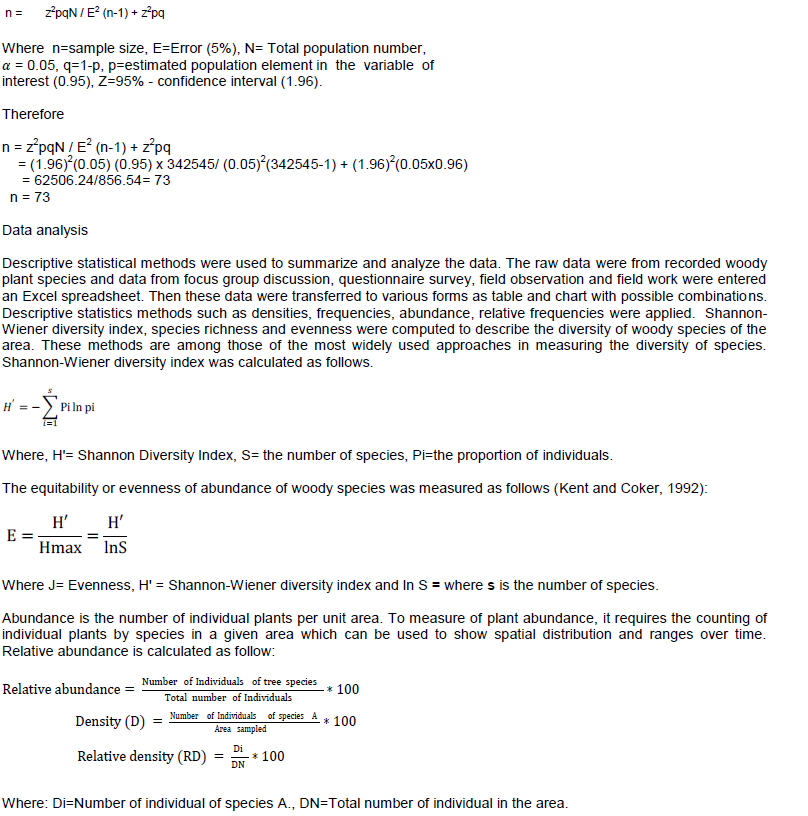
Focus group discussion was implemented to triangulate the responses from household interview on possible solutions of threats of deforestation in the study area. From the analysis of informants suggestion as possible solution of deforestation, reforestation was taken as priority to cope up problems of threats (76.7%) and a major way to minimize the loss of plant diversity followed by afforestation (75.3%), awareness creation (71.23%) and using alternative energy (67.12%) in the community nearby to the forest (Table 6).
The control or reversal of deforestation can, therefore, be achieved by addressing the drivers identified to be currently contributing to deforestation in the study area.
The promotion of alternative energy sources (like biogas and solar energy) should be encouraged to reduce dependence on the use of firewood. Reducing deforestation would also require creating and strengthening reversal of deforestation such as awareness rising on consequences of deforestation (public education) and strengthening participatory forest restoration and protected area expansion programs. This is in line with the same recommendation from Asfawa and Fikadu (2018). It is vital therefore, that the Woreda natural resource administrative body or Forest and environment office to enhances the land use planning process in addition to identifying and implementing appropriate decision to mitigate harmful effects of development activities (like illegal agricultural expansion, urbanization and infrastructure development) on forest resources. During data collection session the researcher observed that, the nearby society still rely on the forest for their daily life activities and most people cut down trees for fuel wood and charcoal production. In general, the rural people in the country and Bensa Woreda get their basic needs from the nature gifted areas without sustainable utilizations and conservation. Wise utilization of natural resources and responsibilities must be considered.
Understanding the resources and process of forest degradation is vital for informing forest management and conservation policy and for an efficient conservation of interventions. This study has quantified the Hotessa forest woody species diversity and dynamics of forest resource degradation and its drivers in southern Ethiopia Sidama Zone Bensa Woreda. A total of 43 woody plants species were identified and recorded. The plant resource in the study area is considerable, the Woreda being relatively rich in plant diversity. Based on Shannon-wiener diversity index analysis, the distributions of species were natural with less human intervention. Socioeconomic characteristics of the respondents showed that mostly males and aged with most of them without any formal education and primary school education and possessed at least a hectare of farmland. Expansion of agricultural land, logging, urbanization and infrastructure development were recorded as a major challenges and negative impact on the biodiversity and soil condition in the area. In the course of this study, it was noticed that farming activities in relation with population growth were greater and a lot of pressure placed on natural resources. Forest might have been losing its diversity through above indicated threats. The long history of exploitation may result to unequal distribution of woody plant species in the forest, and woody plant species before reaching the seedling and sapling stage is under destruction. Hence, proper and integrated approach in implementing policies and strategies related to land resources management should be considered and future study on seedling regeneration status and LULC change is recommended.
The author has not declared any conflict of interests.
The author appreciates Hawassa University for providing fund for this research and also grateful to the staff of Wereda Agricultural Office and farmers of Bensa Wereda for their input in data collection.
REFERENCES
|
Ariti AT, Vliet JV, Verburg PH (2015). Land use and land cover change in the Central Rift Valley of Ethiopia: Assessment of perception and adaptation of stakeholders. Applied Geography 65:20-37.
Crossref
|
|
|
|
Asfaw Z, Fekadu B (2018). Factors affecting smallholder farmers' participation in degraded forest rehabilitation practices. The case of Gemachis District, West Hararghe Zone, Oromia Region, Ethiopia. Journal of Agricultural Extension and Rural Development 10(11):234-244.
Crossref
|
|
|
|
|
Azene B (2007). Useful Trees of Ethiopia: Identification, Propagation and Management in 17 Agro-ecological Zones. Nairobi: RELMA in ICRAF project, p. 552.
|
|
|
|
|
Bessie S, Beyene F, Hundie B, Goshu D, Mulatu Y (2016). Land use/land cover change and its effect on bamboo forest in Benishangul Gumuzregion, Ethiopia. International Journal of Sustainable Development and World Policy 5(1):1-11.
Crossref
|
|
|
|
|
Dagne A, Tamru DT (2018). Floristic Composition and Structure of Zerat Forest, Central Ethiopia. American Scientific Research Journal for Engineering, Technology and Sciences (ASRJETS) ISSN (Print) 2313-4410, ISSN (Online) 2313-4402.
|
|
|
|
|
Daniel E (2016). Deforestation and forest degradation in southern Burkina Faso: Understanding the drivers of change and options for re-vegetation. Dissertation, Helsinki.
|
|
|
|
|
Eba M, Lenjisa D (2017). Assessment of Plant Species Diversity, Relative Abundances and Distribution in Haramaya University, Ethiopia. Journal of Physical Science and Environmental Studies 3(3):30-35.
|
|
|
|
|
Edwards S, Mesfin T, Sebsebe D, Hedberg I (2000). Flora of Ethiopia and Eritrea. The National Herbarium, Addis Ababa University, Addis Ababa and Department of Systematic Botany, Uppsala University, Uppsala 2(1):13.
|
|
|
|
|
Ensermu K, Teshome S (2008). Interface of Regeneration, structure, diversity and use of some plant species in Bonga Forest: a Reservoir for wild coffee gene pool. SINET, Ethiopia Journal of Science 31:21-134.
|
|
|
|
|
FAO (2016). State of the World's Forests. Forests and agriculture: land-use challenges and opportunities. Rome.
|
|
|
|
|
Gashaw T, Dinkayoh T (2015). Land use/land cover dynamics in hulet Wogedamea Kebele, northern Ethiopia. Current Research in Agricultural Sciences 2(1):36-41.
Crossref
|
|
|
|
|
Hedberg I, Ensermu K, Edwards S, Sebsebe D, Persson E (2006). Flora of Ethiopia and Eritrea 5.The National Herbarium, Addis Ababa University, Addis Ababa and Department of Systematic Botany, Uppsala University, Uppsala. p. 36.
|
|
|
|
|
Hedberg I, Friis I, Epersson E (2009). Flora of Ethiopia and Eritrea 8. General Part and Index to 1-7. Addis Ababa, Ethiopia and Uppsala, Sweden.
|
|
|
|
|
Keenan RJ, Reams GA, Achard F, de Freitas JV, Grainger A, Lindquist E (2015). Dynamics of global forest area: Results from the FAO Global Forest Resources Assessment 2015. Forest Ecology and Management 352:9-20.
Crossref
|
|
|
|
|
Kent M, Coker P (1992). Vegetation Description and Analysis: A Practical Approach Belhaven Press, London. 438p.
|
|
|
|
|
Kothari CR (1985). Research Methodology, Methods and Techniques. Wiley Eastern Limited, New Delhi.
|
|
|
|
|
Khumalo S, Chirwa PW, Moyo BH, Syampungani S (2012). The Status of Agrobiodiversity Management and Conservation in Major Agroecosystems of Southern Africa. Agriculture, Ecosystems and Environment 157:17-23.
Crossref
|
|
|
|
|
LIVES (Livestock and irrigation value chain for Ethiopian Smallholders) (2012). Bensa woreda pilot Learning Site diagnosis and program design.
|
|
|
|
|
Moges Y, Eshetu, Z, Nune S (2010). Ethiopia Forest resources: Current status and future management options in view of access to carbon ï¬nances, literature review prepared for the Ethiopian climate change networking. Addis Ababa, Ethiopia: United Nation Development Program (UNDP).
|
|
|
|
|
Mohammed A (2011). Perception of Local Community Towards Deforestation: The Case of Edigetber And Selamber Kebele Around Wolkite Town, Gurage Zone, Snnprs (Doctoral dissertation, Addis Ababauniversity).
|
|
|
|
|
Muller-Dombois D, Ellenberg DH (1974). Aims and Methods of vegetation ecology. - John Willy and sons, Inc., New York.
|
|
|
|
|
Negasi S, Hadgu H, Ted A, Opoku P, Isaac KA, Emiru B (2018). Forest Cover Change, Key Drivers and Community Perception in Wujig Mahgo Waren Forest of Northern Ethiopia.
|
|
|
|
|
Noriko H, Martin H, Veronique DS, Ruth SDF, Maria B, Louis V, Arild A, Erika R (2012). An assessment of deforestation and forest degradation drivers in developing countries. Lop Publishing. Environmental Research Letters 7 (044009):12.
Crossref
|
|
|
|
|
Pielou EC (1969). An introduction to Mathematical Ecology. Wiley, New York.
|
|
|
|
|
Reynolds JF, Smith DMS, Lambin EF, Turner IIBL (2007). Global desertification: building a science for dryland development. Science 316:847e85.
Crossref
|
|
|
|
|
Salafsky ND, Salzer AJ, Stattersfield C, Hilton TR, Neugarten SHM, Butchart B, Collen N, Cox LL, Master SO, Connor DW (2008). A standard lexicon for biodiversity conservation: unified classifications of threats and actions. Conservation Biology 22:897-911.
Crossref
|
|
|
|
|
Stern N (2006). The Economics of climate change: The Stern Review. Cambridge, UK: Cambridge University Press.
Crossref
|
|
|
|
|
Solomon G (2015). Community perception on rangeland degradation: a case study in two different settled areas of northern Ethiopia. Journal of Agricultural Research and Development 5(1).
|
|
|
|
|
Tesfaye A, Anteneh B, Tessema Z (2019). Woody species diversity, population structure, and regeneration status in the Gra-Kahsu natural vegetation, southern Tigray of Ethiopia. Heliyon 5:e01120.
Crossref
|
|
|
|
|
Teweldebrhan G (1988). Vegetation and environment of the mountains of Ethiopia: implications for utilization and conservation. Mountain Research and Development 8:211-216.
Crossref
|
|
|
|
|
Zerihun T, Ensermu K, Tamrat B (2017). Floristic composition and plant community analysis of vegetation in Ilu Gelan district, West Shewa Zone of Oromia region, Central Ethiopia. International Journal of Tropical plant research.
Crossref
|
|