ABSTRACT
This study was conducted with the objectives of comparing range condition of an area under different land use practices (resettled and non-resettled) and assessing the possible effect of resettlement on range condition in Meinit-Shasha district of Bench-Maji zone, southwest Ethiopia. Two kebeles were selected purposively where vegetation and soil conditions were investigated in 40 quadrats across 20 sampling sites using 20 × 20 m (400 m2) quadrat, which was distributed along transects. The investigation included the assessment of grass composition, basal cover, litter cover; age distribution of dominant grasses, number of seedlings and soil conditions (erosion and compaction), which were investigated on 1 × 1 m (1 m2) area. Data from range vegetation survey was analyzed using SAS software. The study results showed significant differences (P < 0.05) between kebeles in terms of grass composition, basal cover, number of seedling and soil condition. The total score for range condition rating showed that the resettled kebele was in the category of poor range condition, whereas the non-resettled was in fair condition. Expansion of crop cultivation and the establishment of permanent settlements as a result of resettlement program were considered to be the main contributing factors to the reduction of grazing lands and poor range condition scores in the resettled kebele. The study showed a higher level of degradation in the resettled kebele than non-resettled kebele. Generally, the results of this study indicated that unplanned resettlement program had a negative influence on rangeland vegetation dynamics. Cautious planning and implementation of resettlement programs in recognition of differences in land use between the host communities and resettlers is suggested. Securing inhabitants’ land tenure would facilitate the recovery of rangeland vegetation and conservation of biodiversity.
Key words: Resettlement, rangeland condition, land use.
Forced by natural disasters and increased frequency of food crisis, people in many parts of rural Ethiopia have relatively remained deprived (Brown and Amdissa, 2007).
In response to the vulgarity of climate change and resultant poverty, resettlements of people to various habitable localities has been implemented as a development strategy by successive regimes in Ethiopia with the aim of alleviating poverty and securing food self-sufficiency. As in the case in many developing nations, resettlement has been becoming a dominant development discourse in Ethiopia since the middle of the last century (Belay et al., 2005; Asrat, 2006).
For example, in Bench-Maji and Kaffa zones, massive state-sponsored resettlements have been ongoing since the 1980s (BoA, 2009). Both the past and present resettlement programs have been focused on and implemented predominantly in the lowland areas of the country where population densities are expected to be low and unutilized lands are assumed to be found. However, the lowland areas in Ethiopia including the Bench-Maji and Kaffa zones are usually inhabited by pastoralists and agro-pastoralists, which are still subsistence-oriented where local livelihoods largely depend on extensive livestock production. Generally, the pastoral and agro-pastoral communities in the study areas largely depend on rangeland vegetation and water resources for their livestock. On the other hand, resettlement in the study area has been carried out without considering the potential land use impacts on the local environmental and people’s livelihood. Moreover, resettlement programs have been ongoing in pastoral areas with no justification and evidence on the transformation of traditional land use practices despite the ecological potentials of the area. This has also been done with little attention on the follow up of impact assessment on natural resources and communities’ way of life. In conjunction with this, there is a gap with regard to land use policy in the country and appropriate development intervention strategies for pastoralists. Most studies in the past were only focused on the socio-economic status of resettlers and their new environment, while impacts on the environment of the host community, their local resources base and livelihoods received little research attention (Wolde-Silassie, 2002; Elizabeth, 2003; Asrat, 2006). The high level of interest in resettlement of rural communities in pastoral areas has greatly affected the historical natural resource and biodiversity of most resettled regions in the country (Elizabeth, 2003; Asrat, 2006). Despite the potential environmental and socio-economic effects of resettlement on the host community, little attention has been given in evaluating the environ-mental impact of resettlement and status of rangeland vegetation as a follow up of resettlement programs. More focus on securing food self-sufficiency of the new settlers might have contributed to severe environmental degradation and deterioration of pastoral land use. Although resettlement programs may temporarily improve the food security problems of resettlers, the ongoing massive state-sponsored resettlement programs have a tendency to cause intended and long-term environmental consequences, which in turn accelerate vulnerability of pastoralists to the impact of climate change and food insecurity. Consequences of resettling farmers in pastoral areas where the type of land use is mostly suitable for extensive livestock production is likely to cause environmental changes thereby creating crisis on sustainable land use and the future of pastoralism. Thus, if food self-sufficiency of resettlers is to be improved, it should be redesigned in such a way to match with the local land use practices to minimize impacts on rangeland biodiversity. A study on the environmental impact of resettlement in pastoral areas and its implication on land use changes, resource utilization and local livelihoods would be useful to realize how resettlements of people could influence the status of rangeland vegetation. Our objective was to assess the effect of resettlement on rangeland condition in relation to different land use practices. Generally, we raised the following research questions: (i) Does resettlement in southwest Ethiopia in its current form have a negative effect on rangeland vegetation?; (ii) What are the impacts of resettlement in terms of land use change on the fragile lowland ecology in terms of change in range vegetation condition?; (iii) How important is changing land use practices which affect vegetation condition in the area?
Study area
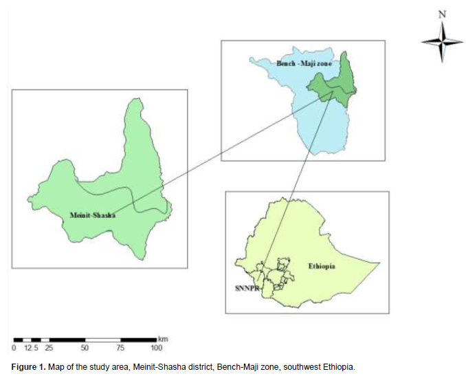
The study was conducted in Meinit-Shasha district of Bench-Maji zone, which is situated in the Southern Nations Nationalities and Peoples’ Region (SNNPR) of Ethiopia (Figure 1). Bench-Maji zone comprised of ten districts, five of which are inhibited by pastoral and agro-pastoral communities and the other five are inhabited by agricultural communities and it include Bench, Sheko, Meinit, Dizi and Surma ethnic groups among which Surma, Meinit and Dizi ethnic groups are recognized as pastoral and agro-pastoral communities. The study district is an area of semi-sedentary combined with transhumant pastoralism. It is located about 617 km from the country’s capital, Addis Ababa, to the southwest part. According to the FDRE-PCC (2008) Population and Housing Census report, the human population of the area is estimated to be 44,766. The elevation ranges from 800 to 1500 m above sea level with varying landscapes ranging from rolling plains to occasional hills and mountains (BoA, 2009). The area is characterized by bimodal rainfall pattern with mean annual rainfall of about 850 mm. The annual maximum temperature in the area is 40°C and the annual minimum temperature is 20°C (BoA, 2009). The vegetation of the study area commonly consists of shrubs and grasses interspersed with numerous large trees such as Entada abyssinica and Acacia species. The vegetation ranges with rainfall from tropical montane rainforest to savanna grasslands. However, the forest exists in very small pockets with wild coffee to the west of the district. Soils of the study area are predominated by sandy-loam textural classes and are generally dark brown to reddish brown. The agricultural landscape is one of relatively small patches of cropland around settlements, with extensive areas of woodland, savannah grassland and shrub land that are used for extensive grazing. The agro-pastoral communities in the area are traditionally dependent on livestock production and some lately started cultivation of sorghum, cassava and maize for their subsistence livelihood. The animals in the area are maintained on rangeland vegetation all year round. The study district is one of the regions with the highest livestock population density. According to BoA (2009), the livestock population was estimated to consist of 56752 of which cattle accounted for 28364, goats 25585 and 2803 sheep. This area was selected because it was a focal point where the Ethiopian government has conducted the resettlement schemes.
Sampling design and data collection procedure
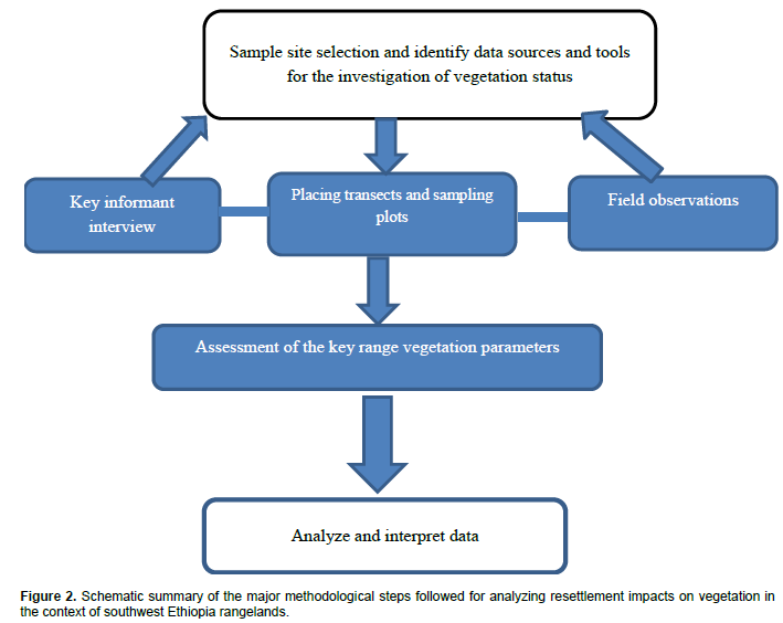
A combination of different methods and techniques including participatory approaches, field observations and vegetation assessment were employed to obtain the objective of this study. Figure 2 depicts the general approaches used in the study.
Two kebeles (peasant associations), that is, one resettled and the other non-resettled were selected for the purpose of this study. The selected kebeles had similar altitudes (800-1490 m) with varying landscapes, climate and soil types but with comparable household and livestock numbers. In this particular case, Eara was the non-resettled kebele and represented the vast rangeland areas that had been used by pastoralists for centuries. On the other hand, Bass was the resettled kebele where the degree of pastoral land use was reduced. Recent and intense expansion of cultivation in Bass kebele was a major challenge to the pastoral land use resulting in the reduction of available grazing lands.
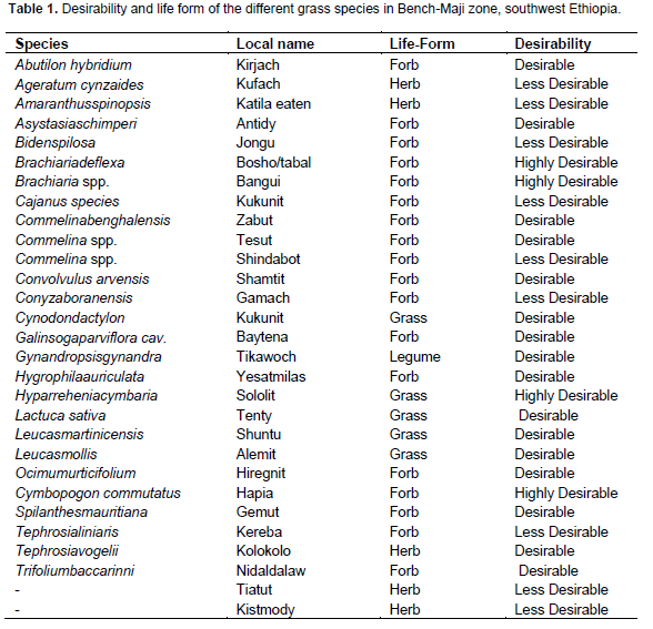
In each kebele, two parallel transects of 8 km long were established in a south-north direction following the path towards a water point and in this particular study water point refers to a permanent River called Kilu (one of the tributaries of Baro River after joining the River Akobo) in the study area. Transects were placed 1 km apart and the sampling plots were established at regular intervals along 800 m transect. Each transect had 10 sampling plots of 20 × 20 m (400 m2), which were fixed using a measuring tape and Silva compass to supply a total of 40 plots (20 plots/kebele). For the range condition factors, a smaller plot size of 1 × 1 m was placed within the edge of 20 × 20 m plots. Sampling was conducted at the time when herbaceous vegetation was in flowering stage towards the end of the main rainy season for the identification of species. Plant specimens were pressed and taken to Haramaya University’s Herbarium for proper identification. To assign the corresponding scientific names, nomenclature of the plant species followed the Flora of Ethiopia (Hedberg and Edwards, 1989; Azene et al., 1993). Overall, parameters recorded included: species composition, basal cover, litter cover, number of seedlings and age distribution.
Range condition assessment
Details of factors considered and criteria employed for rating range condition included: grass composition, age distribution, basal and litter cover, number of seedlings and soil conditions in terms of soil erosion and compaction in each sub-plots based on the criteria developed by Tainton (1981) in South Africa and modified to fit
semi-arid and sub-humid environments by Baars et al. (1997). A maximum score of 10 points each given for 3 of the factors, that is, grass composition, basal cover and litter cover, and a maximum score of 5 points each for age distribution and the number of seedlings, soil erosion and soil compaction were given, summing to a maximum possible score of 50 points to obtain a total range condition score for each kebele. The total rating was interpreted as follows: very poor (≤ 10); poor (11 - 20); fair (21 - 30); good (31 - 40); and excellent (41 - 50) points (Tainton, 1981; Baars et al., 1997).
Grass species composition
Classification of grasses was based on the succession theory of Dyksterhuis (1949), which is also documented in Baars et al. (1997) to classify grasses into desirable species likely to decrease with heavy grazing pressure (decreasers), intermediate species likely to increase with heavy grazing pressure (increasers) and undesirable species likely to increase or invade with heavy grazing pressure (invaders). Information was gathered from pastoralists on vigor and palatability of a particular species. A species with high palatability was considered as decreaser, whereas a species with medium palatability, which is not affected by grazing pressure, was considered as increaser. The score for the grass species composition was determined from the proportion of decreasers, increasers and invaders at each sampling site. A range of 1-10 points was designated for scoring grass composition and the maximum score of 10 points were given if the contribution of decreasers were 91 - 100%, and score of 1 point was given if the decreasers were less than 10 and 50% increasers, respectively and with the rest falling in between 1 and 10 points.
Basal area and litter cover
A representative area of 1 m2 was selected at each sampling site for detailed assessment of basal area and litter covers and divided into 2 halves. One half was further divided into quarters, one of which was divided into eighths. For basal area and litter cover, a score of 0 to 10 points was used. Plant basal cover in the selected 1 m2 was cut, transferred while kept together, and drawn in the eighth segment to facilitate visual estimations of basal cover. Only living plant parts were considered for basal estimation. The highest score of 10 point was given for the basal cover of tufted species if the eighth was completely filled (12.5%). Accordingly, classes of <3, 3-6, 6-9, 9-12% were distinguished. A score of 0 was assigned for no basal cover. Similarly, the rating for the litter cover within the same square meter was given the maximum score of 10 points when it exceeded 40% and the minimum score when the litter cover was less than 3% (Tainton, 1981; Baars et al., 1997). The rating for basal cover of tufted grasses was considered ‘excellent’ when the eighth was completely filled (12.5%) and ‘very poor’ when the cover was less than 3%. The rating for litter cover within the same area of 1 m2 was considered ‘excellent’ when it exceeded 40% and ‘poor’ when less than 10%.
Number of seedlings
The number of seedlings and age categories at each sampling site was counted from 3 randomly selected plots, equal to the size of an A4 paper (30 x 21 cm). The paper was dropped from a height of 2 m above the ground. Scores of 0, 1, 2, 3, 4 and 5 were given if the number of seedlings in the area outlined by the A4 paper were 0, 1, 2, 3, 4 and >4, respectively. Similarly, the size distribution, which was considered to reflect the age distribution of plants, was estimated based on visual observation of the size of the grass tussocks. When all age categories (young, medium aged and old) plants of the dominant species were present, the maximum score points of 5 were given. Young and medium aged plants were defined as having approximately 20 and 50%, respectively, of the biomass of old and mature plants of the dominant species. A score of 4 point was given when both young and medium-aged groups of grasses were present, while scores of 3 and 2 were given when only old and medium-aged groups of plants, respectively, were present. When there were only young plants, the minimum score of 1 point was given.
Soil erosion and soil compaction
The extent of soil erosion and compaction was evaluated from 1 m2 sub-plots subjectively by visual observations. Soil erosion was based on the amount of pedestals (higher part of soils, held together by grass roots, with eroded soil around the tuft of grasses), and in severe cases, the presence of pavements (terraces of flat soil, normally without basal cover, with a line of tufts between pavements) (Baars et al., 1997). If there was no soil movement, a maximum score of 5 point was given and a minimum score of 0 was given in situations where gully formation was observed due to soil erosion. The occurrence of slight sand mulch, weak pedestals, steep-sided pedestals and pavements coincided with scores of 4, 3, 2 and 1, respectively. Soil compaction (1-5) was evaluated based on the amount of crust formation of surface soil. If there was no compaction, a maximum score of 5 was given and the rating was decreased with increasing capping of the soil. Scores of 4, 3, 2 and 1 were given for soils with isolated capping, >50% capping, >75% capping and almost 100% capping, respectively.
Woody vegetation layer
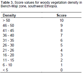
In each sample plot of the 20 x 20 m (400 m2), all woody plant species with diameter at breast height (DBH; 1.30 m above the ground) and shrubs were identified and counted to investigate the woody vegetation density and composition. The height was measured by hypsometer, while diameter of trees was measured with the use of a caliper. The density of woody plants (trees and/or shrubs) was enumerated in each plot and an area with less than 5 trees/shrubs was given 0 point and that with more than 50 trees/shrubs were given a score of 10 points, while other estimates failed in between these limits. Information on the classification of trees/shrubs into preferred and not preferred was obtained in discussion with pastoralists and the corresponding range of scores (0-10 points) was designated.
Data analysis
A one way analysis of variance (ANOVA) using the GLM procedure in SAS (SAS, 2004) was used to verify significant differences in terms of range condition factors in response to the predictor variable, that is, status of settlement between the two kebeles. Means were separated using Duncan’s multiple range test (DMRT). Statistically significance difference was determined at P<0.05.
Composition of herbaceous species
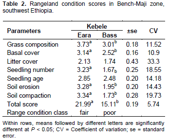
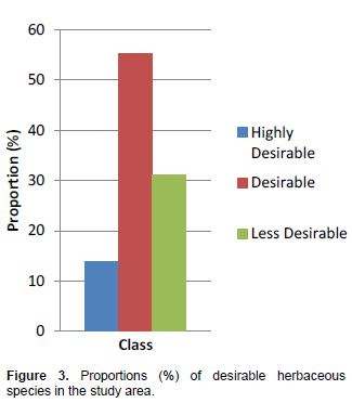
A total of 29 herbaceous species were identified in both kebeles, while the plant species included: 5 grass species, one legume species, eighteen forbs and 5 other herbs (Table 1). Of the total herbaceous species identified, 24 species were recorded in both kebeles, while 4 additional species were only recorded in the non-resettled kebele. On the other hand, one species was only found in the resettled kebele. Among the herbaceous vegetation recorded, species in the categories of highly desirable, desirable and less desirable plant species accounted for 13.8, 55.2 and 31% in both kebeles, respectively (Figure 3). The proportion of highly desirable species was generally lower than the desirable and less desirable ones (Figure 3). Although there is existence of limitations with subjective classification, it gives an indication of deterioration explained by higher grazing impact. There was a significantly higher (P<0.05) score for grass species composition of the non-resettled kebele
(mean=3.73±0.18) than the resettled kebele (mean 3.01±0.18) (Table 2). The basal cover of the herbaceous vegetation of both kebeles (Table 2) was in fair to poor range condition classes for Eara and Bass, respectively. Statistically, our results also showed a significant (P<0.05) difference in terms of basal cover between the two kebeles (Table 2). The mean score for the basal cover was lower for the resettled kebeleas as compared to the non-settled kebele. Overall, litter cover showed no significant difference between the resettled and non-resettled kebeles, although the mean value for the resettled kebele was lower.
There were no significant differences (P>0.05) in ratings for age distribution between the two kebeles. However, the number of seedlings showed significant differences (P< 0.05) between the non-resettled and resettled kebeles (Table 3). The mean score for the resettled kebele in terms of seedling count was lower. The result of this study revealed that, soil erosion and compaction showed a significant difference (P<0.05) between the two kebeles (Table 2). Accordingly, the resettled kebele had a significantly lower score than the other kebele impling the existence of soil erosion and compaction in a particular kebele. The total score for the non-resettled kebele was significantly different (P<0.05) from that of resettled. Based on the total score, the overall condition of the rangeland was in fair range condition (21.99±0.19) class in the non-resettled kebele, but that of resettled kebele was under poor (15.11±0.19) condition class (Table 2).
Species composition of the woody layer
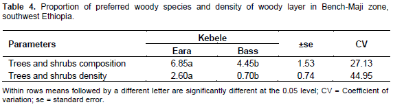
A total of 13 woody plant species were encountered in the study district. Of the identified woody plant species, 61.54 were preferred and the remaining 38.46% were less preferred or not at all preferred for different uses in the study area. Generally, variation existed in composition of the preferred and less preferred woody plants (Table 4). Accordingly, the proportion of tree and shrub vegetation revealed higher values for Eara. A clear difference (P<0.05) was observed in terms of the score value of woody density between the resettled and non-resettled kebeles (Table 3). The score for woody species density was lower for the Bass kebele than Eara (Table 4).
One of the main objectives of this study was to investigate whether resettlement of farmers and subsequent changes in pastoral land use had influenced range condition. The findings of this study indicate that rangeland condition in the resettled kebele greatly differed from that of non-resettled kebele. The findings further confirm that resettlement of farmers’ that had different ways of land use practices as opposed to the pastoral land use system significantly affected the condition of rangeland vegetation. The overall range condition scores for the non-resettled kebele as compared to resettled kebele could attribute to differences between the two kebeles in most of the parameters studied. The lower condition score for the resettled kebele could be attributed to heavy grazing pressure, poor management by newcomers, expansion of crop cultivation and increased resettlement that strongly affected the composition, structure and productivity of rangeland vegetation (LUCID, 2006). Similar results were reported by Amaha (2006), Fikirte (2008), suggesting that increased pressure and population growth are factors for the decline in rangeland condition. Expansion of crop cultivation resulted in a decline in range condition score due to the loss of herbaceous species in terms of reduced basal cover and litter covers. In addition, the establishment of permanent settlements together with the shrinkage of grazing areas substantially affected pastoralists’ grazing strategies as a result of high population and increased grazing pressure.
Herbaceous composition and rangeland condition
These findings indicate that grass composition was in poor condition in the resettled kebele of Bass where traditional grazing management and pastoral land use were no longer practiced. A similar result was reported by Angassa et al. (2006), indicating that range condition reduded with increased sedentarization in Dida-Hara area of Borana rangeland. Overall, changing management conditions linked to settlement and encroachment of cropping in the communal rangelands and deforestation of natural vegetation caused by land preparation for agricultural activities largely contributed to the reduction in grazing lands. As a result, intensive grazing resulted in the loss of herbaceous layer in the resettled kebele. On the other hand, grass species composition was higher in the non-resettled kebele. The probable explanation could be due to the traditional land management practices and presence of extensive grazing areas as compared to the resettled kebele. Earlier report (Macharia and Ekaya, 2005) indicate that anthropogenic factors could have an adverse effect on the composition and productivity of rangeland vegetation, which is consistent with the present finding.
The existence of significant difference in terms of basal cover between the study kebeles suggested that concentrated grazing and poor management practices may lead to the loss of vegetation cover. Basal cover become lower with poor range condition or the vegetation is under degradation (Amaha, 2006). In this study, the relatively good basal cover in the non-resettled kebele could be associated with reduced grazing pressure due to sufficient grazing areas and the role of local institution in resource management. The results of this study indicate that increased resettlement with intense grazing pressure had resulted in the reduction of grass seedlings. The number of grass seedlings generally declined with the advancement of continuous grazing due to lack of mobility. The result of the present study indicates that crop cultivation and overexploitation of the rangeland vegetation could lead to resultant reduction in seedling numbers. According to Amaha (2006), Amiri et al. (2008), heavy grazing, livestock trampling and encroachment of crop cultivation in the rangelands would contribute to the decline in seedling germination and further deterioration of rangeland condition.
Several findings in arid and semi-arid rangelands (Amaha, 2006; Fikirte, 2008; Asheber, 2009) have shown high levels of bare soil due to the hoof action of grazing animals, overgrazing and mismanagement considered as an important factor for soil erosion to occur. The result of this study revealed that soil erosion and compaction showed significant difference (P<0.05) between the two kebeles in which the resettled kebele showed lower values. The likely reasons for this might be the resettlement program which forced agro-pastoralists to be confined to small plots of land following extensive communal land dispossessions, which have put pressure on indigenous communities’ grazing lands to be restricted in small grazing areas particularly on fallow land with the result of overgrazing.
Moreover, expansion of cropping by the resettlers has led to signs of rapid soil erosion in this kebele, exacerbated by reduction of vegetation cover by clearance for cultivation and cutting of wood for fuel and other uses. This result is consistent with a study conducted in Kenya, where fragmentation of the communal rangelands following immigrant farmer’s settlement in the lower parts of Mt. Kenya such as Mbeere and Tharake have confined agro-pastoralists to only family plots. Thus, such pressure resulted in bush clearing and land use change together with continuous cropping contributed to the reduction of vegetation cover, increased soil crusting and compaction, which is believed to encourage rapid soil degradation (LUCID, 2006).
It was observed that the total score for rangeland condition in the non-resettled kebele was significantly (P <0.05) higher than that of resettled areas. The introduction of crop cultivation, establishment and expansion of permanent settlements, and concentrated grazing resulted from the reduction of grazing areas which appear to be the main factor contributing to the relatively lower total score attained in the resettled kebele. Pastoralists in the study area were previously free to move with their livestock and graze across vast communal grazing lands. These patterns of grazing left the rangelands less overgrazed and resilient (Angassa et al., 2006). However, crop cultivation and large population of human settlements were established following the resettlement of farmers since 2004. Accordingly, grazing strategies and land use patterns practiced by the pastoral communities through generation had altered and confined to graze on small plots of land because of reduction of grazing areas and restricted free movement of livestock.
Similarly, the demarcation of enclosed rangelands for the resettlement and encroachment of crop farming into these lands following resettlement that led to a year-round grazing and conversions of the communal rangelands to crop lands, seem to be the main factors contributing to the relatively low condition for range condition scores in resettled kebele.
Although, the sample size used for the assessment was minimal, the observation from the study would suggest that the observed results are indicative of the overall image for the study area. In general, the mean range condition of the study area varied from fair to poor range conditions for the different parameters used in the assessment of Eara and Bass, respectively. The results support earlier findings (Amaha, 2006; Angassa et al., 2006; LUCID, 2006) that reported that heavy grazing, poor management, expansion of cultivation and permanent settlement strongly affect the composition, structure and productivity of range vegetation and generally resulted in the deterioration of rangeland condition in arid and semi-arid rangelands of Ethiopia.
Impact of settlement on woody vegetation
Results on the species composition and density of tree and shrub revealed that there was a significant difference (P< 0.05) between the two kebeles. The results of this study clearly showed that land management and resource utilization practices had different effects on the density and composition of woody layer in the study area. The mean score for woody plants density was significantly lower for Bass, as compared to Eara. Such lower score could be largely attributed to human activities.
These activities which are mainly related to land clearance for cultivation, extensive utilization for fuel and construction material and selective cutting and uprooting to avoid competition with cereal crops, are processes which have caused vegetation destruction. The result indicated that the shrub and tree layers had already been overexploited by inhabitants and the extent of vegetation clearance could be increased following resettlement. The prevention of complete clearance and restricted extraction of woody plants may help in the conservation and management of the natural vegetation. Such measure could not only help for the maintenance of rangeland diversity but also meet the basic needs of livelihoods of the local community in the study area. In line with the present study, Belaynesh (2006) observed that over utilization of trees and/shrubs for fuel and construction material resulted in the loss of woody vegetation with the resultant deterioration of rangelands in arid and semi-arid regions of Eastern Ethiopia. Conversely, the highest mean score of the non-resettled kebele could perhaps be little disturbance for cultivation and other uses.
From the results of these findings, there is a clear indication of rangeland degradation following resettlement of farmers in pastoral lands of southwest Ethiopia. Apart from the permanent settlements on the communal rangelands, expansion of crop cultivation, grazing pressure and reduced mobility of livestock were expected to decrease the status of vegetation cover. The influence of newcomers on the former communal rangelands with increased demand for cereal production than before may block pastoralists’ access to common pool resources. In addition, differences in land use practices between the host community and newcomers could be major factors in triggering land degradation and loss of biodiversity in the region. Fragmentation and alienation of the communal rangelands had undermined the collective role of pastoral land use and management, threatening local institution and indigenous knowledge in resource management.
Generally, given the status of land use and management activities by resettlers, one can safely argue that resettlement in pastoral area is a threat to the local environment, indigenous institutions and rangeland biodiversity. Therefore, better understanding and recognition of the ecological potential of a given region in terms of appropriate land use policy is essential. An integration of indigenous knowledge with modern conservation approaches in planning and implementation is crucial with the full participation of the local community.
Moreover, resettling farmers in pastoral lands may not be a viable policy option to secure food self-sufficiency in the long-term. It seems that alternative policy option that fully recognizes the customary land use tenure may be more practical.
Understanding the influence that resettlement and lack of proper land use policies have had on pastoral land use and consequently rangeland degradation, the develop-ment of pastoral land policy and ensure sustainable rural development should be guided.
The authors have not declared any conflict of interest.
REFERENCES
|
Amaha K (2006). Characterization of Rangeland Resources and Dynamics of the Pastoral Production Systems in the Somali Region of Eastern Ethiopia. PhD Dissertation Presented to the University of the Free State, Bloemfontein, South Africa.
|
|
|
|
Amiri F, Ariapour A, Fadai, S (2008) Effects of Livestock Grazing on Vegetation Composition and Soil Moisture Properties in Grazed and Non-Grazed Range Site. J. Biol. Sci. 8:1289-1297.
Crossref
|
|
|
|
|
Asheber T (2009). Biophysical Factors as Impacted by Livestock Distribution in Relation to Watering Point in Allaidege Rangeland, Zone 3 of Afar Regional State, Northeastern Ethiopia. An Msc thesis presented to School of Graduate Studies Haramaya University. pp. 75-76.
|
|
|
|
|
Asrat T (2006). Resettlement and Food Security with Reference to the Ethiopian Experience: The Boreda Case, Awassa, Ethiopia.
|
|
|
|
|
Angassa A, Tolera A, Belayneh A (2006). The Effects of Physical Environment on the Condition of Rangelands In Borana. Trop. Grasslands 40:33-39.
|
|
|
|
|
Azene B, Ann B, Bo T (1993). Useful Trees and Shrubs for Ethiopia: Identification, Propagation and Management for agricultural and Pastoral communities. Technical hand book No 5.
|
|
|
|
|
Baars RMT, Chileshe EC, Kalokoni DM (1997). Technical note: Range condition in high cattle density areas in the western province of Zambia. Trop. Grasslands 31:569-573.
|
|
|
|
|
Belay K, Beyene F, Manig W (2005). Coping with drought among pastoral and agro-pastoral communities in eastern Ethiopia. J. Rural Dev. 28:185-210.
|
|
|
|
|
BOA (2009). Bureau of agriculture and rural development zonal office annual report July 2009 (unpublished report).
|
|
|
|
|
Brown T, Amdissa T (2007). Implementing Policies for Chronic Poverty in Ethiopia, CPRC and ODI
|
|
|
|
|
Elizabeth SE (2003). Eco-health and Displacement: A Case Study of Resettlement and Return in Ethiopia, FES Outstanding graduate student paper series, 7 No.1, Faculty of Environmental Studies (FES), York University, Toronto, Ontario.
|
|
|
|
|
Federal Democratic Republic of Ethiopia- Population Census Commission (FDRE-PCC) (2008). Summary and Statistical Report of the 2007 Population and Housing Census.
|
|
|
|
|
Fikirte H (2008). Rangeland Resource Utilization and Condition Assessment in Afdem District of Shinile Zone, Eastern Ethiopia. An Msc Thesis presented to the School of Graduate Studies, Haramaya University.
|
|
|
|
|
Hedberg I, Edwards S (1989). Flora of Ethiopia. Vol. 3.The National Herbarium, Addis Ababa, Ethiopia.
|
|
|
|
|
LUCID (2006). Working Policy Brief No.2, Arid and Semi-Arid Agro-Pastoral Systems in Transition.
|
|
|
|
|
Macharia PN, Ekaya WN (2005). The impact of rangeland condition and trend To the grazing resources. J. Hum. Ecol. 17(2):143-147.
|
|
|
|
|
SAS (2004). SAS Institute Inc. Cary, NC, USA.
|
|
|
|
|
Tainton NM (1981). The assessment of veld condition. In:Tainton, N.M. (ed.) Veld and Pasture Management in South Africa. (Shuter and Shooter Ltd: Pietermaritzburg, South Africa).
|
|
|
|
|
Wolde-Selassie A (2002). Social re-articulation after resettlement: observing the Beles Valley scheme in Ethiopia.
|
|