ABSTRACT
Saltwater intrusion problems are widespread where there are over pumping of groundwater from coastal aquifers. Water samples were collected from production boreholes in Zanzibar municipality and analyzed for salinity indication parameters comprising of chloride, electrical conductivity, total dissolved salts and percentage salinity levels. Historical water quality data of boreholes were also collected and used to establish trends. The water quality results indicated that the groundwater from the boreholes is progressively becoming more saline against the pumping age. The increase in salinity indicates progressive saltwater ingress in the aquifers. These trends show that saltwater intrusion is still limited around the shoreline areas especially Beit-el-Ras and Mbweni. The aquifer under the historic Stone Town area is also showing high potential for saltwater intrusion for which increased pumping of groundwater may render it saline. To curb this problem, controlled groundwater pumping and establishment of a long-term monitoring programme have been recommended.
Key words: Zanzibar, groundwater, saltwater intrusion, water quality, Tanzania, stalinization
Saltwater intrusion is a common problem in coastal areas where over-pumping of groundwater occurs. It results in salinization of fresh groundwater tapped in wells and boreholes and therefore rendering it unsuitable for domestic supplies and other uses. Saltwater intrusion is not reversible, once it happens, the wells will be abandoned and the aquifer cannot readily be used (Black, 1977). This is a waste of resource that leads to scarcity of water for the people and increased costs for water. For municipalities in developing countries, like Zanzibar, provision of alternative water source could take many years due to inadequate financial resource. This could mean suffering on part of the communities and other water related health problems arising from using water sources of inferior quality. The normal control mechanism for saltwater intrusion problem is to maintain the proper balance between pumping rates and aquifer recharging capacity. This works only where groundwater monitoring is practiced, otherwise in its absence, the intrusion could happen without notice.
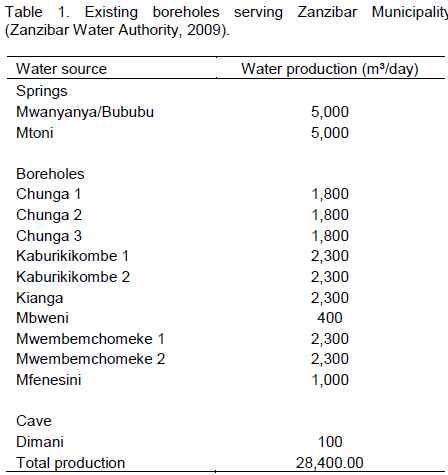
The Zanzibar Municipality relies on groundwater as a sole source of water supplies. The public water authority meets only about 62% of the water demand which is estimated at 45,000 m3/day, the remainder being sourced from private boreholes and shallow wells (Revolutionary Government of Zanzibar, 2004). About 30% of the water is lost in the distribution system before reaching the consumers. The State of Environment Report (Revolutionary Government of Zanzibar, 2004) mentions availability of water among the priority issues of Zanzibar. Since 1950s, the government of Zanzibar has progressively developed systems for groundwater abstraction. There are currently 11 production boreholes with a total water pumping rate of 18,300 m3/day (Zanzibar Water Authority, 2009). The boreholes are located within the urban area and many are close to the Indian Ocean coast. There are also springs and caves providing 10,100 m3/day (Table 1). A thorough assessment to balance pumping rate with aquifer capacity was not conducted. The present increase in population and drive for enhanced tourism on the island is forcing more water production from the boreholes hence posing a potential threat to sea water intrusion in the aquifers. This assessment was conducted to investigate the extent of sea water intrusion in the existing boreholes.
Description of the study area
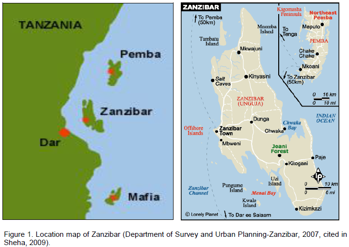
This research was conducted in Zanzibar Municipality, Tanzania Islands. Zanzibar is part of the United Republic of Tanzania, East Africa, located within the Indian Ocean and is composed of two major islands of Unguja and Pemba. Zanzibar Municipality is the headquarters of Zanzibar and lies on the Unguja Island (Figure 1). The islands are located between latitude 4°50' and 6°30' South, and longitude 39°10' and 39°50'. Unguja is the largest island occurring at approximate 40 km off the coast of Tanzania mainland. The island is 86 km long and 39 km wide, with an area of 3,354 km2.and population density of 460 persons per square kilometer. Pemba is situated about 40 km to the north east of Unguja, and is 68km long and 23 km wide, with an area of 1,537 km2 (Revolutionary Government of Zanzibar, 2004).
According to the 2012 national census, Zanzibar (Unguja and Pemba islands) has a population of 1,303,569 growing at 2.8% per annum (United Republic of Tanzania, 2013). Unguja island had 896,761 and Pemba 406,848 being 68.8 and 31.2% of the population of Zanzibar respectively. The Zanzibar town has a population of 223,000, which is about 24.9 and 17% of the total population of the Unguja Island and entire Zanzibar respectively. Zanzibar islands are bestowed with magnificent coastal areas offering diverse potentials for tourism development. As a result, coastal areas are becoming more populated with intensified socio-economic activities (especially tourism based activities) thus greatly impacting on the natural resources base among of which is the groundwater.
The geological and hydrogeological setting of Zanzibar is characterized by lower Miocene rocks consisting of deltaic sandstones associated with marls and minor reef limestone (Sikat, 2011). The major aquifers occur in the Quaternary limestone (Q2), Quaternary sand (Q3), Miocene limestone (M1) and Miocene sand (M3) (Kent et al., 1971; Sikat, 2011; Vuai, 2012).
Methodology
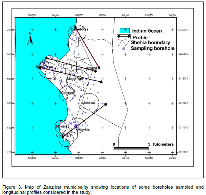
The study was carried out for six months from January to June 2004. Further updates were conducted between January and June 2009 (Sheha, 2009). A total of 154 boreholes in Zanzibar Municipality were investigated. Water samples were collected from the boreholes and analyzed for salinity linked parameters including electrical conductivity, chlorides, total dissolved solids (TDS) and salinity percentage. Other parameters like nitrogen nitrate and faecal coliforms were also determined. Samples analysis was done in the Environmental Engineering Laboratory, Ardhi University, Dar es Salaam. Historical water quality data of the boreholes were collected from the Zanzibar Water Authority (ZAWA) records. Borehole positions were determined by a hand held GPS. Spatial analysis was done to determine areal extent of the sea water intrusion and to enable determination of longitudinal water quality variation across the municipality. Four longitudinal profiles were used, namely, Beit-el-Ras to Amani (3800 m), Stone Town to Amani (4500 m), Stone Town to Mombasa (4800 m) and Chukwani to Mombasa (1620 m).
Groundwater abstraction
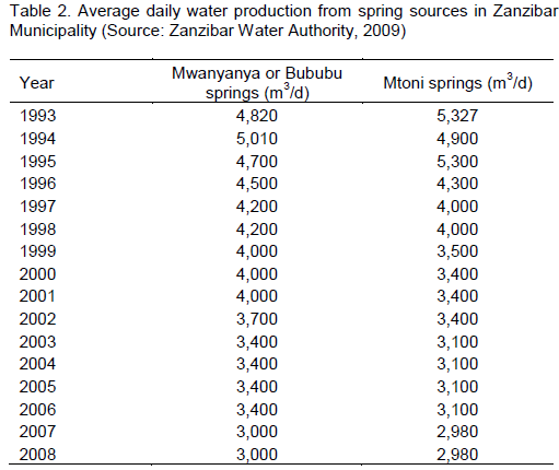
Sustainability of the present water sources for the Zanzibar municipality is not quite understood. Groundwater is the sole source of water supply, abstracted through boreholes, springs and caves. There are 13 water sources of which 30% are located within the urbanized area. Although more than 70% of the municipality residents are connected to public water system, it does not meet the demand (Table 1) and as such there are many private operated boreholes. There are observed water decline from the spring sources (Table 2) signaling further water scarcity and more private borehole drilling. There is no registration or monitoring of boreholes drilling and/or operation (control of pumped water) and hence groundwater

withdrawal rates are not known. Many surveyed boreholes in this study are privately owned located at business premises or institutions. Boreholes have been drilled from a distance of less than 70 m from the Indian Ocean shoreline (Beit-el-Ras) to more than 3 km (Kaburikikombe) within the municipality boundaries. Coast areas like Stone Town (the historical town), Beit-el-Ras, Mtoni and Mbweni have many shallow and boreholes apart from being connected to central water articulation system. Continued unregulated boreholes drilling and groundwater abstraction in the municipality thus threatens the seawater/freshwater balance in the underneath aquifers with consequential seawater intrusion. With the advent of present drive towards tourism sector expansion and rapid population increase in Zanzibar more stress on the aquifer is anticipated that may result into complete aquifer degradation from saltwater intrusion if groundwater abstraction will not be checked.
Water quality changes indicating saltwater intrusion
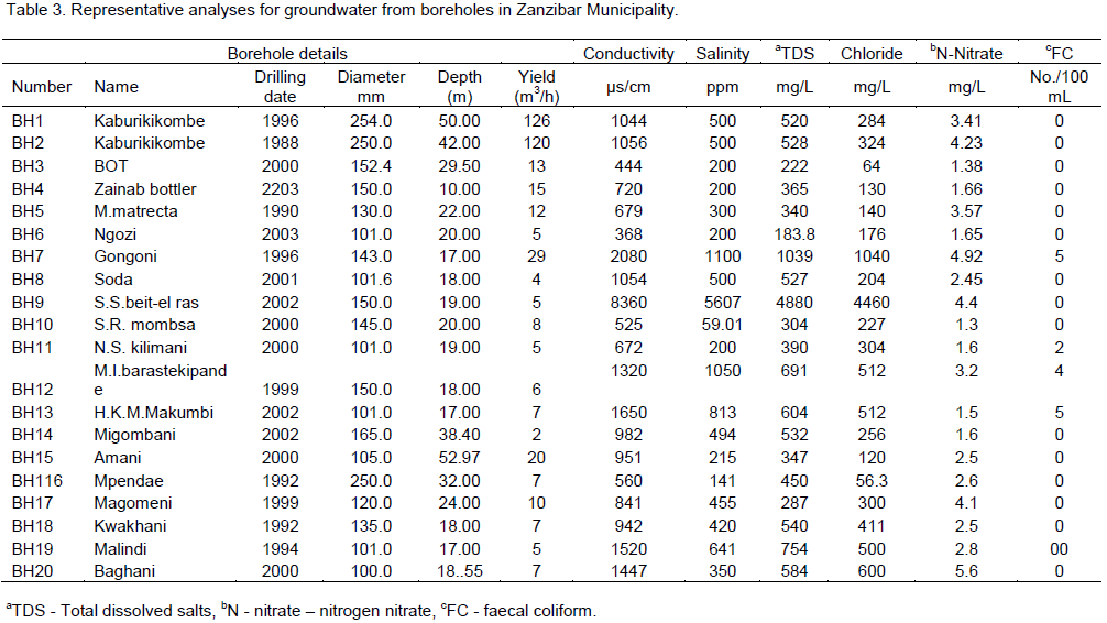
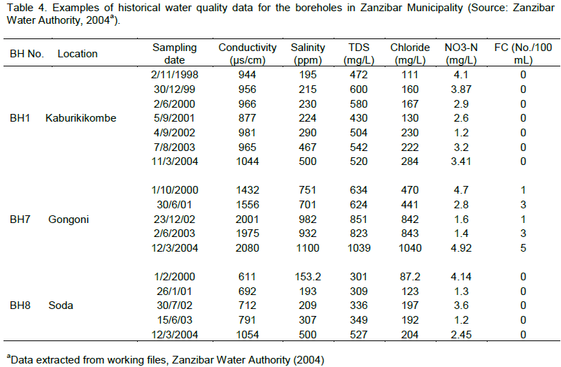
The results of laboratory analysis and historical water quality data of the boreholes in Zanzibar Municipality are shown in Tables 3 and 4, respectively. Available water quality data obtained at Kaburikikombe boreholes span from 1988 and was used to track saltwater intrusion trend. About 97% of boreholes analyzed show a positive trend in conductivity, salinity, TDS, and chloride levels Examples of the positive trends are shown in Figure 2 for Kaburikikombe boreholes which are


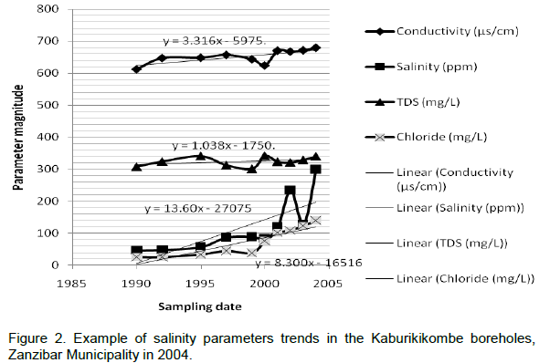
located about 3 km from the shoreline. The data indicate remarkable changes in groundwater quality, especially salinity variations. Increased salinity in groundwater coupled with elevated abstraction rates commonly leads to saltwater intrusion. Unregulated groundwater extraction and increased water demand related to population increase and tourism investment in Zanzibar has been assumed to have triggered salt water intrusion which is reflected by elevated salinity in boreholes. In this case there are some evidences that the increased salinity may be due to saltwater intrusion. For instance there was a marked chloride changes for BH1 (Kaburikikombe) from 110 mg/l in 1993 to 284 mg/l in 2004 (60% increase) while the nitrate-nitrogen levels remained very low (less than 4 mg/l). Should the sewage disposal in the municipality have an impact on the chloride levels in the water from the boreholes it was expected to have elevated levels of nitrate-nitrogen or at least a positive trend.
Longitudinal variation in water quality was noted from the sea shore along the four profiles (Figure 3). Generally, boreholes located close to the coastline showed relatively higher salinity, TDS, conductivity and chloride levels than inland boreholes. Chloride concentration of 2000-6500 mg/l and 1000-2000 mg/l were observed in some boreholes located 0- 100m and 100-1000m from the sea line. A steep longitudinal gradient was observed along the Beit-el-Ras to Amani profile where chloride dropped from 4500 mg/l to less than 300 mg/l. The other profiles had a rather flatter concentration gradients in all the four parameters measured.
Generally the water quality data indicate that Beit-el-Ras and Mbweni areas are more threatened with saltwater intrusion problems than the rest of the municipality beach areas of Chukwani, Mbweni, Kilimani and Stone Town due to more number of boreholes showing progressive increases in salinity levels, many of which exceeded 2000 ppm. These levels are early indicators of major salt water intrusion problems that could occur should the present uncontrolled groundwater pumping practices continue.
It is quite evident from the study that there are evident signs of saltwater intrusion in the coastal aquifers underneath the Zanzibar municipality. The groundwater salinity increase trend is exacerbated by increased water demand arising from the high population density and expansion in the tourism industry on the island. Uncontrolled groundwater pumping presents a real water resources management problem that could easily deplete the only freshwater resource sustaining the island. Occurrence of saltwater intrusion will increase water scarcity on the island and literally adding more poverty to the people apart from causing more health related problems. The water resources authorities in Zanzibar should therefore take proactive steps towards curbing the saltwater intrusion threats by controlling the groundwater withdrawal and putting in place long-term monitoring system.
The authors did not declare any conflict of interest.
The author would wish to give thanks to Sabra Said Abdalla and Sheha Mjaja Juma for their important contributions in this study.
REFERENCES
|
Black JA (1977). Water Pollution Technology. Reston Publishing Company Inc., Virginia.
|
|
|
|
Kent P, Hunt J, Johnstone D (1971). The Geological and Geophysical Coastal Tanzania, Geophysical Paper 6, Institute of Geophysical Paper, London. pp. 101.
|
|
|
|
|
Revolutionary Government of Zanzibar (2004). State of Environment for Zanzibar, Department of Environment.
|
|
|
|
|
Sheha MJ (2009). The impacts of urbanization expansion on groundwater sources: case study of Zanzibar Municipality. M.Sc. Dissertation, Ardhi University, Tanzania. Unpublished.
|
|
|
|
|
Sikat LB (2011), Assessing the spatial and temporal characteristics of groundwater recharge in Zanzaibar: Towards the optimal management of groundwater resources. Published M.Sc. Thesis, University of Twente, The Netherlands.
|
|
|
|
|
United Republic of Tanzania (2013). Population and Housing Census.
|
|
|
|
|
Vuai SAH (2012). Geochemical chaaracteristics of spaleotherm formation in caves from Zanzibar island, Tanzania. Open Access. 1:505.doi:10.417/scientificreports.505.
|
|
|
|
|
Zanzibar Water Authority (2009). Zanzibar Water Strategy for 2009-2015. Unpublished.
|
|